White, East Fork
Hindostan Falls (PnP)
| Difficulty | I-II(IV) |
| Length | 0.3 mi |
| Avg Gradient | n/a |
| Gauge | East Fork White River at Shoals, in |
| Flow Rate as of 1 hour | 4960 cfsmedium runnable |
| Reach Info Last Updated | April 2, 2019 |
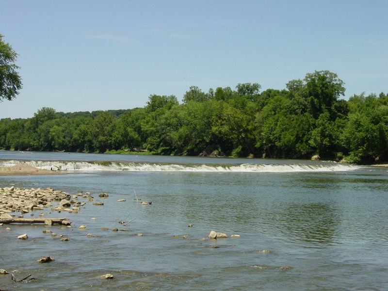
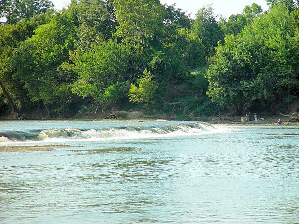
This single short ledge/falls (with a campground and boat ramp adjacent) may provide some entertainment at the right water levels.
Additionally, there appear to be a number of smaller creeks in this immediate vicinity which have significant drop into the White River. While virtually none of them appear to sustain adequate size or gradient to merit a run of any length, the final plunge may provide some variety of entertainment (with adequate flows and appropriate scouting for runnability).
Thomas Visnius provides:
The water quality is typical Midwest large river agricultural, but not foul or caustic. Ear and nose plugs would help during extended play sessions. There are absolutely no other waves nearby, on the White, so if you want to float down the fairly scenic and quiet stretches near Hindostan Falls, use a large comfortable boat (canoe, touring kayak, raft, or dory), and drag a tiny play boat behind you. There are a few nice little creeks, cliffs, and cracks along the river.
He also provides the following links which may be of interest:
Subglacial meltwater channels in sandstone at Hindostan Falls, Martin County, Indiana
Indiana Magazine of History, 1920
books on Martin County, by Bill Whorrall
article on the history of the settlement of Hindostan, Indiana
Jul 21, 2012
At 555 CFS it was runnable in a few spots, you had to know exactly where to go & as wide as the river is there it's easy to miss your target areas (which were small) and possibly either run aground or worse get stuck sideways in a channel & get flipped over. 3 different spots had about 2-3 foot wide channels that were the best spots they are within about 35ft of the left side bank. There it had enough water to get you to & over the falls (a 3 to 4 foot quick drop at 555 CFS). It is very doable in the right spot's & it's really quite fun. Below the falls for a several hundred feet it has good current with slight rapids & is also a fun area but gets pretty boring real fast right after that.
Jul 29, 2009
It was a very good morning. I wished that I could have stayed all day. I used an older, crummy coolpix camera, from my cockpit, so the combination of low resolution, pink pixels, and bouncing photographer resulted in some mysterious, unclear images.
Jul 25, 2009
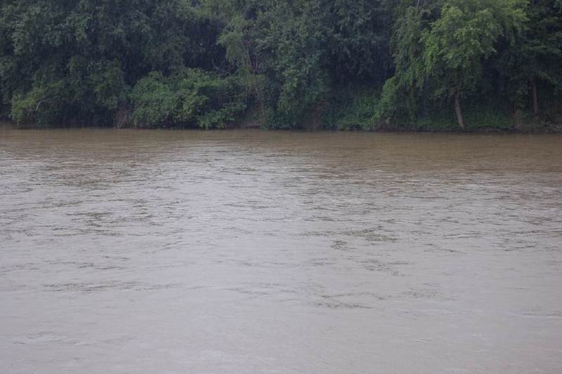
The good news: After a three inch day of rain on Wednesday July 22, the river spiked, eventually peaking at 11,000cfs a day later and holding there for almost an entire day. The level dropped slower than it rose, so that Saturday morning it was at 7600 and continuing its gradual descent. This seemed like a good day to catch the falls at their peak and watch them change as the level dropped. I loaded two ducks, my Grim Wafer, two kids, and a friend, and we headed south. We took highway 450, to get a look at Williams Dam, with 7000cfs on the Bedford gauge. It is a deadly, horrific lowhead dam, pictures included.
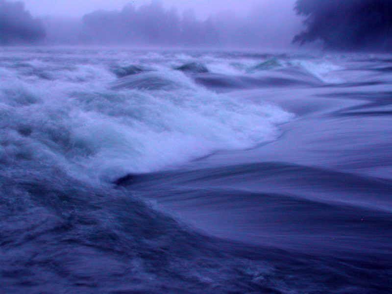
The bad news, although it is still good news for gauging runnability: When we arrived at the falls, they were completely inundated by the high water. The Shoals gauge read 8400cfs at the time we arrived (1:30pm), and it climbed to 8500 by the time we left (3:30pm). There were violent, but fast-moving storms blowing east, early that morning. The difference between the 7000 at nearby Bedford and the 8500 at Shoals indicate that the local streams near Shoals can contribute a 1000-2000 cfs with any decent storm. This is significant if you are chasing cells, but luckily, the East Fork as a whole has a large, gradual drainage. So if the cells are passing over the entire drainage, the spike will drop slowly over a couple of days at least, as indicated by the spike from the Wednesday 7/22 storms. As for the 8400cfs, it is too high for any kind of play worth driving for. We could see a hint of activity from the falls under our boats, and from the micro-eddy just downstream. I was able to use the large downstream eddy for mysteries and squirts, but they were not worth the drive. I am revising my guess for the maximum play level to 7000cfs, and that is factoring in squirting, which should be fun at higher levels than surface play. Surface play, such as wave and hole surfing, might top out 6000cfs. Since we're just guessing anyway, I will now say that the play window is 2500-6000, with some marginal fun at 2000-2500 and 6000-7000. Pictures of 8500cfs are included.
Jul 8, 2009
We put in near the 550 bridge, about 2 miles upstream. Put in at Shoals for a nice, long run with an easy bike shuttle across the big bend. We finally got a close look at this three foot monster, and every time I gaze upon it, I feel sucked into a rip in a space-time continuum. View the full-sized versions of the two panoramas for better viewing. They are composed of about eight pictures each and look great when viewed at the full 100%, with sideways scrolling.
2600 cfs may be a low level for surface play, but there could be some mystery play at this level. I was in a canoe with family, so I was not able to probe. I am guessing that 3000 opens up all types of play along the entire rip. I will also guess that this ledge and the eddies downstream will pack a lot of fun for expert play boaters up to 10,000 cfs. I can't say for sure, since I have yet to play it, but this should be worth a 2 hour drive. The river did not start to rise until a full day after the heavy rains of July 4, and it is still rising 3 days (maybe more) later. This is a very easy run to plan for.
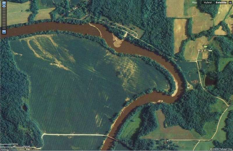
Most satellite views of Hindostan Falls are a capture of the river at a high level, so that you never see the ledge. I am not sure yet at which level it starts to wash out. The Yahoo satellite map does depict the ledge, so it is included in the gallery for reference. Here is a link to it,
http://maps.yahoo.com/#mvt=s&lat=38.622178&lon=-86.849359&zoom=17
The East Fork of the White River sees 2000-10,000 through much of the year, except for late summer and fall. The river sees 20,000 regularly, although that is surely too high for any features to play, other than some possible boils. I will try to scout some of the higher flows this winter. Over 40,000 is about when property starts getting damaged. The water quality is typical midwest large river agricultural, but not foul or caustic. Ear and nose plugs would help during extended play sessions.
There are absolutely no other waves nearby, on the White, so if you want to float down the fairly scenic and quiet stretches near Hindostan Falls, use a large comfortable boat (canoe, touring kayak, raft, or dory), and drag a tiny play boat behind you. There are a few nice little creeks, cliffs, and cracks along the river.
This photo gallery description is not written with beginner canoeists and kayakers in mind. The ledge could easily trap a boater sideways, and turning over in the falls could easily result in head and shoulders getting pounded on rocks. The hydraulic could also trap a swimmer, which could result in drowning.