Johnnies Creek
1. Upper Upper - CR 43 to CR 47
January 1, 1900
| Reporter | Robert Maxwell |
This is John Stephan running boogie water at the beginning of the run. (The level is -2' on Canyon Rim Road/SR 176 gage and -6' on Hwy 176 gage.)
Amy Conger runs increasingly steep boogie water near the beginning of the run. (The level is -2' on Canyon Rim Road/SR 176 gage and -6' on Hwy 176 gage.)
Things start to narrow down somewhere in the middle of the run. (The level is -2' on Canyon Rim Road/SR 176 gage and -6' on Hwy 176 gage.)
We portaged this one. (The level is -2' on Canyon Rim Road/SR 176 gage and -6' on Hwy 176 gage.)
Nice scene in the gorge. (The level is -2' on Canyon Rim Road/SR 176 gage and -6' on Hwy 176 gage.)
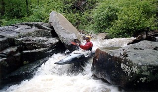
This is a shot of the top of Tombstone. One of the most challenging rapids on the run. (The level is -2' on Canyon Rim Road/SR 176 gage and -6' on Hwy 176 gage.)
John Stephan runs Tombstone, one of the most challenging rapids on the run. (The level is -2' on Canyon Rim Road/SR 176 gage and -6' on Hwy 176 gage.)
Probably one of the most interesting rapids I've run. The object here is to 'go fast, turn left' and don't hit the wall. If you do you might die, there is a sieve on river right under the rock. I'm not sure if the rock is undercut or not. (The level is -2' on Canyon Rim Road/SR 176 gage and -6' on Hwy 176 gage.)
This is the pool below In Memory of #3. (The level is -2' on Canyon Rim Road/SR 176 gage and -6' on Hwy 176 gage.)
Amy Conger runs Lick Skillet Dam while John Stephan and Tad Day look on. Running the Dam is the opposite of running Oceanna on Tallulah. (The level is -2' on Canyon Rim Road/SR 176 gage and -6' on Hwy 176 gage.)
John Stephan runs Tombstone, one of the most challenging rapids on the run. (The level is -2' on Canyon Rim Road/SR 176 gage and -6' on Hwy 176 gage.) For the full-sized version of this picture, click here.