Johnnies Creek
1. Upper Upper - CR 43 to CR 47
| Difficulty | III-IV |
| Length | n/a |
| Avg Gradient | n/a |
| Gauge | Little River Near Blue Pond Al |
| Flow Rate as of 1 hour | 50 cfsbelow recommended |
| Reach Info Last Updated | January 3, 2006 |
Upper Johnnie's Creek 5/4/2002
RangerRob
If you look at AW's description of
Upper Johnnies Creek in Little River Canyon in AL, it describes it as a 6-mile, 2-3 run that starts off at Hwy 176. This description is very inaccurate! The class 2-3 section is from the first bridge upstream to the regular put-in for the canyon run. If you put-in on HWY 176 you'll find a very different run than is described in AW's web site.
Last Saturday, I took a group to run 'something' in AL. We finally ended up at LRC @ 3.5'. I decided to check the creeks. Johnnies was at -2', so I decided to check out the upper section, since the group wasn't as strong as I'd like to run regular Johnnies. We put in on the first crossing of Johnnies Creek's headwaters on HWY 176. (I now refer to this as the Upper Upper Put-In) The creek, very quickly, drops into a class 3 - 4 gorge that was very continuous and nicely technical. A little tougher then 'Teddy' Bear Creek. One rapid of note, we named 'In Memory Of #3' -- for all you race fans.
The rapid was a creek-wide boulder pile/ledge drop that dropped about 5 feet. Six feet from the base of the drop was a semi-truck size wall of a boulder that was almost river wide - starting from river right. The right side of this boulder had a sieve, similar to Fist on the Russell Fork. The only way to run it was hard left, with a strong boof then an immediate correction to the left, in order to avoid pitoning into the boulder. The boulder didn't appear to be undercut, other then the sieve on the right. A few who ran it had to brace off the wall and the current pushed them out to the pool below.
At a certain point the gradient eased and we -- believe it or not -- found a lake in the middle of Johnnies creek!!! Yes it is an honest lake. It's Lick Skillet Lake and has been there for 20 years. I think it's a private lake, and all roads leading to
...Aug 14, 2004
This weekend I painted a gage on Upper Johnnies Creek. The gage is on the downstream river right wall of the culvert on Hwy 176. Best seen from river left. The step in the culvert is 0
Jan 1, 1900
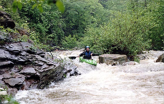
This is John Stephan running boogie water at the beginning of the run. (The level is -2' on Canyon Rim Road/SR 176 gage and -6' on Hwy 176 gage.)
Amy Conger runs increasingly steep boogie water near the beginning of the run. (The level is -2' on Canyon Rim Road/SR 176 gage and -6' on Hwy 176 gage.)
Things start to narrow down somewhere in the middle of the run. (The level is -2' on Canyon Rim Road/SR 176 gage and -6' on Hwy 176 gage.)
We portaged this one. (The level is -2' on Canyon Rim Road/SR 176 gage and -6' on Hwy 176 gage.)
Nice scene in the gorge. (The level is -2' on Canyon Rim Road/SR 176 gage and -6' on Hwy 176 gage.)
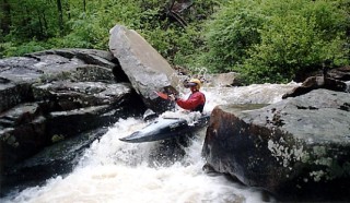
This is a shot of the top of Tombstone. One of the most challenging rapids on the run. (The level is -2' on Canyon Rim Road/SR 176 gage and -6' on Hwy 176 gage.)
John Stephan runs Tombstone, one of the most challenging rapids on the run. (The level is -2' on Canyon Rim Road/SR 176 gage and -6' on Hwy 176 gage.)
Probably one of the most interesting rapids I've run. The object here is to 'go fast, turn left' and don't hit the wall. If you do you might die, there is a sieve on river right under the rock. I'm not sure if the rock is undercut or not. (The level is -2' on Canyon Rim Road/SR 176 gage and -6' on Hwy 176 gage.)
This is the pool below In Memory of #3. (The level is -2' on Canyon Rim Road/SR 176 gage and -6' on Hwy 176 gage.)
Amy Conger runs Lick Skillet Dam while John Stephan and Tad Day look on. Running the Dam is the opposite of running Oceanna on Tallulah. (The level is -2' on Canyon Rim Road/SR 176 gage and -6' on Hwy 176 gage.)
John Stephan runs Tombstone, one of the most challenging rapids on the run. (The level is -2' on Canyon Rim Road/SR 176 gage and -6' on Hwy 176 gage.) For the full-sized version of this picture, click here.