| Difficulty | II(III) |
| Length | 5.4 mi |
| Avg Gradient | n/a |
| Gauge | Esopus Creek at Allaben Ny |
| Flow Rate as of 22 minutes | 39 cfsbelow recommended |
| Reach Info Last Updated | April 21, 2016 |
River Description
This is the section immediately *above* the whitewater release section and only runs with natural flow. It's primairly a class II run becoming class III with very high water.
Put in at fishing access on county rt. 47 in Big Indian. Take out at Allaben near portal or continue on with more water if the portal is releasing.
Catskills Area Reaches
Basic CreekBatavia Kill Bear Kill
Beaver Kill (Delaware Trib)Beaver Kill (Hudson Trib) Beer Kill
Beer Kill, W. BranchBowery Creek Bush Kill
Callicoon Creek, E. BranchCallicoon Creek, N. Branch Catskill Creek (1.)
...River Features
Put In
Access PointDistance: 0 mi
Take Out
Access PointDistance: 5 mi
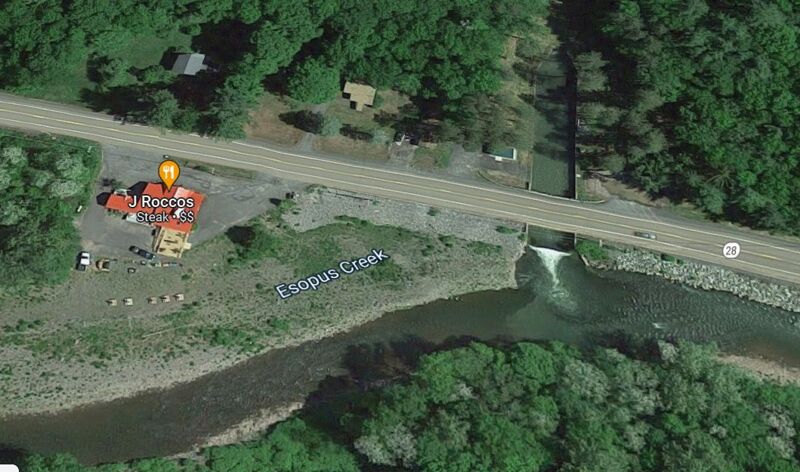
There appears to be a nice surf wave located at the takout from a side trubutary.
Not sure how to know when the side tributary is flowing, it looks like it is coming from underground.
Trip Reports
Log in to add a reportDH
Playwave - Drew Hoselton
Dec 20, 2022
There appears to be a pretty nice play wave located at the takout. I don't know anything about the levels required but have heard some good reports on it.
It does not look like it is actualy part of the Esopos but possibly a tributary or release. Looks like it is coming from under ground.
Here is a link to a video.
LM
Linda McLuckie
May 18, 2012
It's also very easy to put in at the west end of the route 28 bridge that's right in Big Indian. Put in on the upstream side, which is actually Birch creek perhaps 150 yards upstream of the Esopus. You can then park in the small park by the east end of the bridge. You'll have some fast, narrow stuff to start with, so be vigilant for strainers. At moderately high water I didn't think this was much more than class 2, but a roll and the ability to stop could be very important. About 1/2 mile below route 28 is the bridge for Firehouse Road. Shortly below this is an abrupt drop with a horizon line. I'm not sure if it collects wood, but it would be a very good idea to scout this ahead of time. [Edit: Irene seems to have flattened this out. The current goes right, with a pronounced drop, but not a horizon line. **I've only looked at it from the bridge, so it might be harder to see from your boat.] I'd guess that 500 cfs on the Allaben gauge is pretty low (At 350 CFS on 5/17/12 I thought it looked like it needed another couple hundred CFS to be decent). 1000 was fast and fluid.