Raven Fork
1. Right Fork to Enloe Creek Trail
| Difficulty | IV-V |
| Length | 4 mi |
| Avg Gradient | 218 fpm |
| Gauge | Oconaluftee River at Birdtown, Nc |
| Flow Rate as of 32 minutes | 342 cfsbelow recommended |
| Reach Info Last Updated | January 3, 2025 |
The Raven Fork is the most remote wilderness in the Smokies. The upper reaches were first paddled by Kirk Eddlemon and Sean Kennedy on September 24th, 2006.
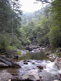
Three Forks is the highest extent of boatable waters for all reasonable purposes. This is 4 miles above the river at the Enloe Creek trail crossing. Much of the forest in this upper reach is virgin timber, with large hemlocks and other firs towering over the more typical smokies vegetation. The rock is of the utmost quality and after the first mile and a half of low gradient scrabble, bedrock dominates the river corridor for the rest of the plunge to Big Cove. This two and a half mile stretch to the iron bridge has enchanting scenery, frequent class 3-4+ rapids of high quality, and an isolated feel not often found in the southeast. Though the gorges in the Jocassee watershed, Linville Gorge in NC, and the Shining Rock region have equally impressive character, none have such low visitation, and the Raven Fork must have the best water quality in the southeast. This is due to the fact that there are absolutely no roads in or above the watershed, and excepting the AT at the top of the ridge, no impact by man whatsoever. All this leads to one of the truest wilderness experiences available in the region. Bring a lunch and a camera!
However, you will also need good shoes and a strong will, for the path into the Three Forks region is very difficult. There are two routes into Three Forks and neither are easy. Both start at the same trailhead in Round Bottom. Drive into the park on Straight Fork Road and continue past the Hyatt Ridge trailhead another mile and a half to the crossing of the creek. Park just shy of the bridge and begin here. It is 3.7 long miles to campsite 44 at McGee Spring, from whence the decision is to be made. In the first 3 miles exists the bulk of difficulty. The trail gains 2000 feet in this stretch, so eat breakfast. Once on the top of Hyatt Ridge, there will be an intersection with
...