Apalachee
5 & 6: 441/Pot Leaf Shoals to Lake Oconee
| Difficulty | II-III |
| Length | 11.5 mi |
| Avg Gradient | n/a |
| Gauge | Apalachee River Near Bostwick, Ga |
| Flow Rate as of 1 hour | 135 cfsbelow recommended |
| Reach Info Last Updated | April 8, 2022 |
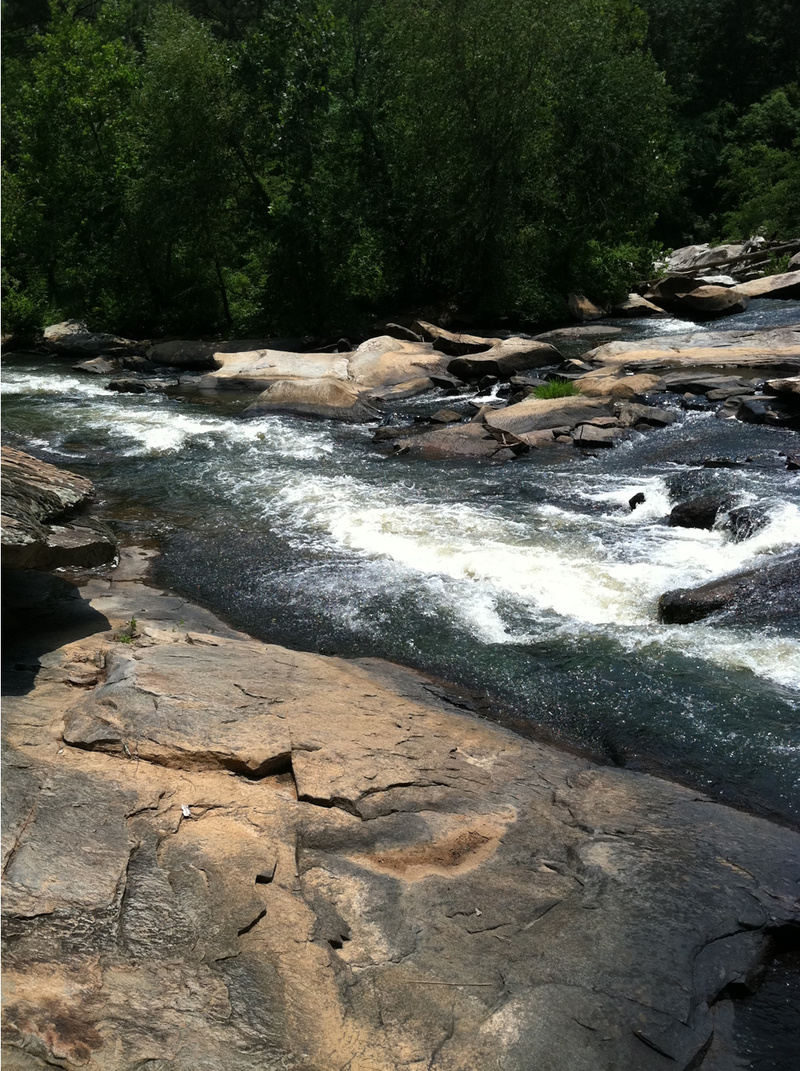
Shortly below 441 is Pot Leaf Shoals, a long rapid that wasa great park and play spot until all roads leading to it were gated. In theoryone could put-in at 441, float down to Pot Leaf Shoals, then paddle backupstream. Depending on the flows, Pot Leaf is class III-IV+. Continuing downstream, the river de-evolves into swamps. The first swamp is less than half a mile long and is early warning for what is to come. The river recombines into a single channel and you feel relieved but not for long. The 2nd swamp is 2-3 miles long, depending on the level and how lost you become. The river splits and recombines with abandon, creating a maze that has befuddled many a crew. Channels disappear into massive root strainers, forcing one to get out onto 'islands' and scout for the nearest navigable channel. See below for some of the accounts of past expeditions. To navigate the swamps the following advice is offered: go when vegetation is minimal (winter or earlyspring), go when the level is >1500 cfs at Bostwick, bring a GPS and a healthy sense of adventure. The 2nd swamp ends, with the river recombining into a single channel, right at Trimble Bridge Road.
As of April 2022, if the 'Experience' of the art piece on the railway bridge piling is half-way under water or more, beware, Pot Leaf Shoals is a solid 4+ with a large recirculating keeper midstream in the last drop, making it really a 5. Get out early river left to scout, though this is private property. It may be possible to set safety above and below the keeper. Otherwise scout/portage river right. River right does have an open channel but there may be piton and pinning hazards.
Continuing on to section 6, or putting in at Trimble Bridge,the river does flow quickly but with no shoals or swamps. Do be aware of strainers. This section isabundant with wildlife and is bordered on river left by forest land and onriv
...
Fun little wave at low water but develops
into fun but shallow play hole around 400
cfs. Above 1000 cfs, it turns back into a BIG
trianglular steep wave that offers great
surfing. However, at that level it has a pretty
meaty hole that develops closely behind it
on river left.

Fun hole for blasts, blastwheels, etc but too
shallow to throw ends in. Does have a rock
on river left that your boat will hit when
throwing blast wheels, but still plenty of fun
from 175-400 cfs or so. Above 400 cfs, the
hole gets pretty rough and all of the current
throws you into the rock mentioned above
pretty hard, making it real hard to do much
blasting, etc. Great eddyline seam above
and below the hole for squirts, flatwater
wheels, etc.
Sep 9, 2019
I have been paddling and researching the Appalachee for the last few years. I would like to restructure the 3 reaches currently listed in the AW database with 4 sections. These would be labeled 2-5 and would go from Treadwell Bridge Road (just above Hwy 78) to Hwy 278 at Lake Oconee. This would encompass 36 miles. The restructure will enable updates to be made concerning access, rapids, dams and the infamous swamp. Sections 0, 1 would be reserved for the upstream reaches I have not paddled yet. The restructuring would be done so as to preserve existing information (comments, etc) for the 3 sections already in place. If you have comments, suggestions, please let me know. Thanks!
Jul 5, 2013
I paddled this in a canoe with a friend some 30 years ago so I can't speak to the Hwy441 access as of 2013. What I can tell you is despite the terrain map look or the appearance of water on satellite, you CANNOT paddle from 441 to Lake Oconee. About 4-5 miles below shoals, water becomes swampy and it is that way for a couple miles...map shows a Timber Bridge Rd (dirt) and that is last thing that resembles a road for access. Go past the old iron bridge frame (visible in satellite image) and you are likely to be walking in a swamp with three feet of mud rather than paddling..
Jul 14, 2011
I just went out to the shoals last weekend. The gate is still up on Old Madison Hwy, but I didn't see any no trespassing signs for the road there. It is clear the logging companies don't want you to trespass in the forests, but I think that is more to keep hunters out. The bridge access at 441 is still accessible from any side. The Madison county side has a concrete pad with a dirt road that leads under the bridge. I made it down with a 2wd truck, and there was a sedan already down there that made it out with no trouble. It looks like the best bet is to put in at the bridge and take out at the beach area below the shoals. You can park a car on Old Madison above the gate. Just be ready for a 1/4-1/2 mile hike uphill on a gravel road. I will post some pictures of the shoals. The water was low when I went, but it looks like it could be fun.
Jul 8, 2011
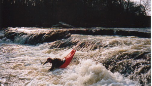
These are some pictures of the shoals I took last weekend. There is a small wave train above a pool (surfing wave at higher water). The pool empties into two small drops, both of these flood out at higher water to form the blasting hole. I also included a picture of the pot leaf painted on the rocks. I am assuming this is where the shoals got their name.
Jul 13, 2009
Went this past weekend. Put in at Price Mill Road and paddled to 441 bridge. Bit of a long drag down a big hill at Price Mill, but wasnt bad. Water flowed well first 2-3 miles but then slowed down considerably. Flowing about 61 cfs I believe. Had to pick up and drag about 5 times.
Took out at 441. Washouts on access were kinda rough, but a 2wd truck made it down. Would not want to attempt this aftter a rain though. We did not paddle down any farther than 441, but in my canoe guide it talks about a take out 1 mile past 441.
Local sources tell me that there is a road that leads to the river there (Old Madison Hwy??), but a timber company has gated the road about 1/4 mile from river. To my knowledge the road is still public and it will be a long drag, but free to use.
I dont know how they got approval to gate a public road?
Kevin: I don't think they got approval; they just did it and it hasn't been challenged yet. Pot Leaf shoals was a classic park and play spot.
Dec 8, 2004
AW received a report today 12/8/04 that the access to this section has been closed.
'I found on your web site a cool play spot on the Appalachee River that is close enough to get in my boat and get wet without driving far. Well, I went there today and a person has bought all the land from the bridge on 441/129 all the way down and has posted several gates with the Classic 'NO Trespassing' signs. I talked with locals and he does not live there, but to be safe in the backwoods of Georgia I would rather not take my chance with the law. I thought I would try further upstream, but there would be no way to hike my boat out without stepping on this guys property due to the fact that he bought both sides of the river.'
If you have more information, please notify AW at kevin@amwhitewater.org.