Mill Creek
Cohuttas - Along Mill Creek Rd.
| Difficulty | III-V+ |
| Length | 6.4 mi |
| Avg Gradient | 200 fpm |
| Gauge | Mill Creek Near Crandall, Ga |
| Flow Rate as of 1 hour | 12 cfs |
| Reach Info Last Updated | February 26, 2003 |
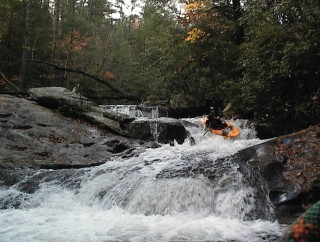
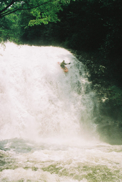
Mill creek runs beside the road most of the way. It has many put in and takeout options. If you like steep gradient,ledges, and large waterfalls the first mile from Hickey Gap campground has it droping 350 ft. Driving from Hickey Gap back down to the takeout the creek will appear again at a pulloff large enough for 2 cars. This is a good put-in for the lower 2 miles with some III-IV creeking. The first takeout is at two drain tiles that flow under upper Rocky Flats ORV trail. The second takeout is where Rocky Flats trail crosses the stream. The first rapid from Hickey Gap put-in is 'Ooh My Liver' noted for all the beer drank around this rapid, two slides finished by two small ledges. Continous boogie water will bring you to a bend to the left and a rock wall on river right. Get out on the right and walk down to 'Hickey Gap Falls' a 45ft waterfall with a tricky entrance. The line appears to be center or left. After running two ledges below the falls get out on the right again and look at 'Lower falls' a 10ft ledge into a very steep and long slide. The line is down the right. Know where these drops are cause at higher flows eddies become few and far between. These both should be portaged on the river right. After the Lower falls a few more rapids then the road will appear again. 1.5 miles from here you will enter 'The Staircase' a long class IV that can be seen from the road. As with all small creeks, lots of wood and strainers in this one.
Other runs nearby are:
40+ feet into a shallow pool. Only run once to anyones knowledge.
Feb 3, 2013
2/22/03 Chip Verner and I ran the lower 2 miles at 1.7 on the bridge. I recall a few portages around strainers and several limbo's. Very continous, tight, and small eddies. I think the best way to internet gauge anything in the Cohuttas is with the usgs Mill creek near Crandall gauge #8361. Its location is just a few miles below rocky flats ORV trail and is the only usgs gauge we have in the Cohuttas. Haven't got it dialed in or corelations yet but around 2.5ft is showing good signs of water in the Cohuttas. Check this gauge and post flows, time, and dates. This gauge reports often and should be great once we get it dialed in. Thanks cohuttariverrat
Nov 11, 2009
Hickey Gap Falls was successfully ran again today, November 11, 2009, by Jeff West, Matthew Wallace, and Mark Bowman.
Oct 11, 2005
Hickey gap falls must have a lot of water to run. a level of 1.8' is optimum but 2'+ would be great for aeration and the landing.
Mar 3, 2005
As of feb, 2005, from hickey gap to tunnel take out, there are 3 class V, alot of class IV, two portages due to trees, at higher water maybe no portages but it would have to be 2 - 2.5'(scary but fun as hell). all the drops have been run consecutiveley at 2', great level, but not fun solo.
Sep 17, 2004
This is my home run and favorite southeastern creek. I would love to hear about someone running the whole thing from Hickey's Gap to the Rocky Flats tile. I know that there are alot of locals who should be running it.
Jul 8, 2004
Hickey Gap falls first descent.
On June 26 2004 hickey gap falls was run by Obie Jenkins. The water level was a healthy medium and the falls has got to be taller than 45'. Please note that the river right side of the pool is only 4' deep, the river left side is 8' deep, and the long slide at the top of the falls is just as tall as the vertical part, so you haul ass off the last part. Witnessed and photographed by Keith Broadwater and his father Barry Broadwater. I will submit pictures soon. If this isnt the first descent please let me know.
Jun 26, 2004
The right side of the pool is 4ft deep an the left side is 8ft deep. Long slide before the vert sends you down with some major speed.