Piney Branch
Piney Creek Ravine (2 miles)
| Difficulty | III-IV |
| Length | 2.3 mi |
| Avg Gradient | 48 fpm |
| Reach Info Last Updated | April 2, 2019 |
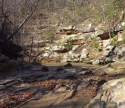
Piney Creek may be the premier 'creek run' of Southern Illinois, but as of 2011 the Superintendent of State Nature Preserves asserted that the river is closed to boating. The whitewater section is two miles long, but the middle half-mile is where the whitewater is. The creek rounds a bend and enters a micro gorge. The creek bottom turns to bedrock and the walls close in. The first rapid is an 8 foot ledge. The pool is shallow (only 2-4 ft deep). The whitewater section continues across a half dozen more slides and ledges (ranging from 4-6 feet) for the next half-mile. A few drops would be blind and challenging. All drops are overhanging and undercut. The last ledge drop has significant vertical pin potential on river right.
The Illinois Department of Natural Resources has decided to ban boating on Piney Creek. The language describing the ban can be found here. Paddlers may also be interested in reviewing the Nature Preseve regulations, and the General Management Provisions. Hiking is allowed in unlimited numbers both on and off trail. Paddlers desiring the basic right to float down this publicly managed river should contact their legislators and the Governor.

Drainage area at our listed put-in is approximately 3.5 sq.mi. (as calculated via USGS StreamStats Beta software). A drainage this small generally requires either major snowmelt or significant rains (over an inch/hour) to see anything close to boatable flows, and then you have to be there while its raining, or immediately upon it stopping. Literally within an hour or two after the rain stops you are likely to be too late.
Eight foot waterfall into a relatively shallow pool (2-4ft). The falls are undercut on both sides at the bottom but the undercuts run largely parallel with the stream flow.
Similar to 8 foot ledge, but the pool is not as clean. On river right, there is a large boulder with the potential for a vertical pin.
No trip reports yet.