Catawba, South Fork
5. McAdenville

| Difficulty | I-II |
| Length | 2.1 mi |
| Avg Gradient | n/a |
| Gauge | South Fork Catawba River at Lowell, Nc |
| Flow Rate as of 1 hour | 2.33 ftlow runnable |
| Reach Info Last Updated | December 12, 2025 |
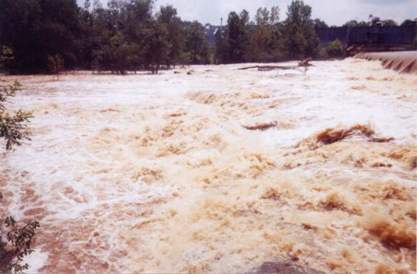
South Fork of the Catawba river. The picture is of the Dam at flood levels. I did not take it.
The takeout I would recommend for this section is at the Catawba Riverkeepers boathouse. This is on river right directly after the I85 bridge. Don't miss it as the dam is downstream. There is a nice parking lot here and a boat ramp too. There is also a walking trail that ends here so it is easy to look at the river and find a put in. Be nice, be respectful, and don't put in from someone's backyard
The highest I have run this section is at 9ft, but I have heard of it being run up into the teens. Above 7 ft things start to get washed out.
After the Dam I have not personally run, but you can see some whitewater from the bridge. Looks to be some very fun class 3 slides and holes. Would have to find a way down to the bottom to put in though.
The river splits around an island here. Stay to the river left for easy boogie and river right for a little stretch of rapid. Lots of fun moves and lines can be done here and there is a small surf wave at the bottom from the river right eddy. On higher flows can get washed out but still fun. Stay to the river left after as the river splits again as it dries out on river right.
One of the best surf waves on the river. Named after the rapid M-Wave at the USNWC. Make a ferry move from river right out into the center of the river and catch the eddy next to it. Prime flows for this wave are 3-4ft.
Rapid with a couple different moves. Sneak line is far river left. The main line is a fun 90 degree turn into a small slot right behind the big rock in the center of the river.
There are 3 main slots here at the site of an old bridge. River left slot is the easiest and has some fun splashy waves. The center slot is blocked unless there is high flow. Don't go down the center slow. The river right slot has a fun wave at the very top that can surf more than one boat at a time. After this wave it is read and run until the pool at the bottom.
The play wave at the top is obtanable from the river right eddy but you have to paddle hard.
On river left the water continues as small boggie. River right has some slots. The middle one has a nice boof rock at good flows. Scout from the boat before you run so you don't pin as the slots change with the water flow.
Fun landmark on the river is an old crashed van on river left. Before the hurricane it was submerged, but has since washed up on the bank. Ferry over to it and catch the eddy behind to look into it. last main feature until the takeout.
Take out at The Boathouse owned by Catawba riverkeepers. Don't run the dam
May 28, 2009
Hi Justin Collins here,
As far as water quality, I dont know. I paddle the S. Fork weekly. During the drought it ran clear. A fish company in Lincolnton round 1900's used to catch trout in town along with other fish and sale to the local community so they say. Also used to be able to paddle up Walker Branch off Clarks Creek as near back as1950's.
When it rains it appears to be erosion pollution and trash. I believe the sod farms take more water than the dairy farms they replaced. they produce high levels of chemicals from over fertilizing and constant watering from Clarks Creek and S. Fork River lower the river levels. NO more erosion from cows or cow poop in the river. Thanks EPA.
The sewer smells worse when the flows are lower, i am not sure how flow and discharge are checked for proper discharge ratio. Smell may come from holding ponds and not being able to discharge.
The 'Rainbow River' is gone, long before the cotton mills or dye houses. Memory just tells great stories of the imagination to remember. I havent seen colors in the river in more than 10 years. I agree the residues and deposits may remain. If you are concerned please find out and let the rest of us know. I swim in sections and most of the old mill dams are swarmed by local people daily and have for years attracted all folks on a warm day. when i am paddling it is rare not to see someone on acanoe, raft, paddle boat, john boat, or sitting on the bank. Like i said im a boater not a sewage expert or water quality scientist.
To the rest of those seeking a great paddle I suggest any section of the S. Fork. Including the Henry Fork and Jacobs Fork. If you are looking for a family float or fishing trip then I suggest from Lincolnton downstream. There are 7 dams to portage. Some being more (adventure) difficult. I believe the Spencer Mtn to McAdenville section is great for quick paddles , introductory boating and incredible scenery outings. All within 25 mins of downtown Charlotte. And no charge for parking! If you dont have equipment and gear check out ncflatwateroutfitters.com and if you want a guide and/or equipment check out http://www.countrymanlivery.com
Justin Collins
704.740.9250
justin@countrymanlivery.com