Trip Reports
Log in to add a reportMK
SF Owyhee Pipeline to 45 Ranch - Matt Kuckuk
May 3, 2023
We ran the South Fork in 2020 and again this year April 27-28, 2023. The Rome gauge for this latest trip was steady at 4,000 and Crutcher was steady at 1,200. We estimated around 1,000 in the South Fork. Note that it's not possible to put in at YP ranch anymore -- the owner has not been granting permission to cross the ranch land and use that access point. Also note that the access roads in the whole area of the upper forks of the Owyhee are long, unpaved and often difficult.
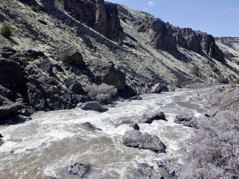
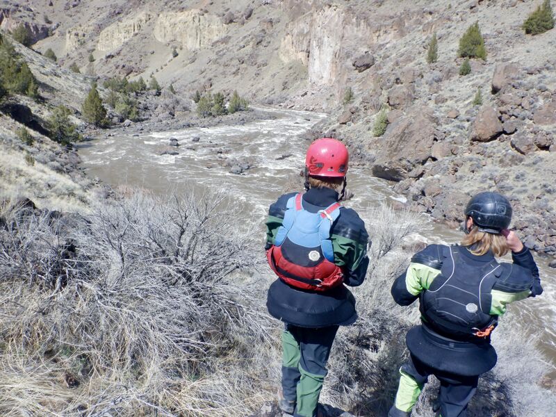
An earlier trip report described this as 'not a whitewater run', which is not exactly accurate, though it is true that the East Fork and Main have many more challenging rapids than the South Fork. Below Pipeline are three good class 3 rapids at this flow: Pinball, an unnamed drop below Stateline, and Sentinel. They each required some maneuvering by our 12-14' rafts, but were no problem for us or the kayakers. The rest of the rapids marked by the BLM on their map were class 2. The 45 Dam was a straighforward run at this level, 2+ or 3-.
As others have noted, the BLM-marked campsites are often nowhere to be found, and other sites exist but aren't marked, so it's best not to put too much faith in the map to find campsites. Especially at higher flows where beaches and sandbars will be covered.
The section has beautiful volcanic-canyon scenery as is typical of this river system, and on our recent trip we saw abundant wildlife as well in this remote wilderness area.
If you plan to take out at 45 Ranch as we did, it's a good idea to take a close look at the takeout itself when setting the shuttle, especially if it's your first time. You want to be sure you can spot it from the river and get through any brush that's grown up around it.
This is a short 25 mile run with a long access drive and shuttle, but it does make a good 2 or 3 day option if that's what you want.
MF
SF Trip Report: Pipeline Launch Site to Three Forks - Matthias Fostvedt
Apr 20, 2023
Our group tried to run Deep Creek (EF Owyhee tributary), but we ran into impassable snow about 10 miles from the put-in. So we pivoted to a South Fork Owyhee trip.
Launched at SF Pipeline Launch Site on Wednesday, April 12. Crutchers gauge 8,500 and dropping; Rome gauge 12,500 and dropping.
Took out at Three Forks on Sunday, April 16. Crutchers gauge 2,500 and holding; Rome gauge 5,500 and holding.
Shuttle took about 5 hours from Three Forks to the SF Pipeline launch site. Even though Duck Valley was basically a lake, the road to the South Fork put-in was fine with stock 4x4 pickups. There were two steep hills, but it was mild by Owyhee standards.
Flows felt like high side of medium on the South Fork and the Upper Main down to Three Forks. Enough water to make easy miles. Enough water to make the rapids very clean.
There are only about five rapids on the South Fork. At our flows, none were harder than class III. On the Upper Main, the two standout rapids—Cabin and Cable—were class IV. Cabin was long and a bit pushy. We basically ran left the whole rapid. Cable was dangerous due to the sieve pile in the middle... but also not very difficult. We boofed into the upper left eddy and then followed the main current back center at the bottom of the rapid. Due to the hazards, about half our group walked Cable on river right.
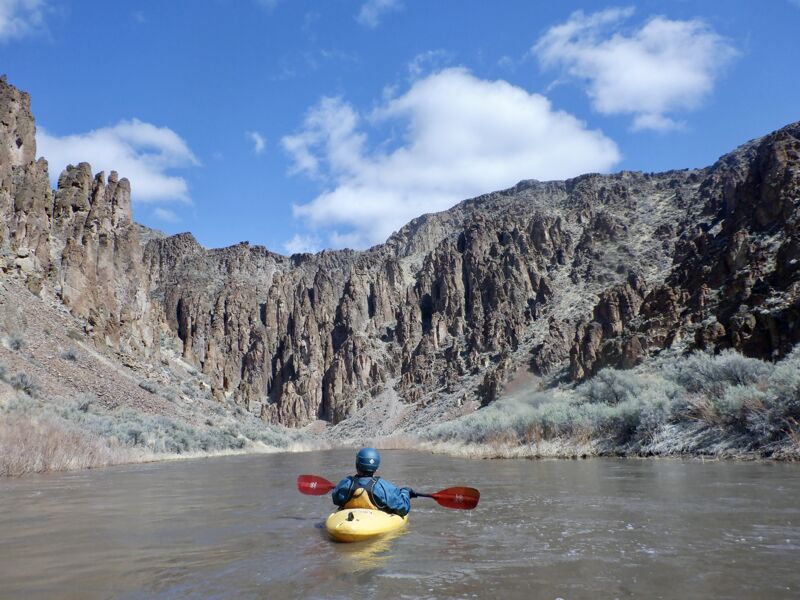
Scenery-wise, the South Fork starts out in open sagebrush country, but gets more gorged-up and scenic throughout the trip. The Upper Main was classic rhyolite canyons the whole way down. Didn't see any wildlife, but there was great shed hunting throughout the trip.
Camping was unique. None of the sites on the BLM map looked like camps. Every camp we stayed at seemed like a random place that had never been camped at. It was a cool experience and very different from staying at established camps on other popular trips.
Lots of cool stops along the way. Tons of old abandoned homesteads, including Bull Camp, which is where Claude Dallas murdered the two F&G officers in the 1980s. Highly recommend hiking up to the obvious cave high on river right above Cable. Tons of artifacts in there, including the most preserved arrowheads I've ever seen.
That's about it. Great trip. Get in touch with any questions. Pics below:
(1) Typical SF Scenery;
(2) Shed Harvest
Cheers,
Matthias
BR
Brad Roberts
Sep 2, 2003
THE SOUTH FORK
7-days. 120 miles.
We put-in at a local ranch in Nevada, miles from nowhere. The first three days of this trip does not have the tight, rocky, nearly impassable rapids that are found on the East Fork. The South Fork meets the East Fork on the fourth day, so the last three days of this trip are the same as the last three of the East Fork trip. There is at least one portage below the confluence of the two forks. (A portage requires that we carry all gear around the rapids. Sometimes we can let the rafts through on ropes (called 'lining,') but this depends on water levels. If we can't line the rafts, we have to carry them as well. Hence the beauty of using lighter inflatable kayaks.)
BR
Brad Roberts
Sep 2, 2003
Owyhee River, South Fork
The South Fork of the upper Owyhee, from head of the canyon put in at the YP (aka Petan) Ranch in Nevada to confluence with East Fork, is an easy 30- odd mile paddle through some of the most remote and spectacular canyon country in the continental U.S.
Unlike the East Fork, it is not a whitewater run. At flows above 250 cfs, an amateur can easily do it in an open canoe. There are three class 3 rapids and a diversion dam to contend with. At flows above 3000 cfs, the threes are largely washed out. At lower flows, some parts may have to be lined depending on skill. The diversion dam at 45 Ranch used to be runnable. However, it was blown out during the '93 flood and rebuilt with nice, sharp rip-rap. Use your own judgment. The portage is easy.
Landmarks along the way include:
*12-Mile Cabin: Homesteader ruin on right bank about 12 miles down from put in. Here, the relatively open basalt canyon begins to narrow to the familiar vertical-walled rhyolite canyon that the upper Owyhee is known for.
*Devil's Corral Rapid: Short class 3. No big deal.
*El Paso Pipline Crossing: Road access. Alternate put-in. Warning: road was blown out during '93 flood. Don't know if it's been rebuilt. Probably not. Things move slowly (if at all) over there.
*Devils Pinball Rapids: A two-mile-long series of fun class 3 bumps leading to the Idaho border. Open canoes may have to line some parts depending on skill.
*Bull Camp. Homesteader ruin on right bank. This was the camp of Claude Dallas when he killed the Idaho Fish and Game cops. His camp was located directly across the river about 50 feet up the bank.
*Coyote Hole: Homesteader ruin on right bank. First good source of fresh spring water. Lots of thundereggs lying about. The ruin is a work of art. Lots of thought and talent went into building this stone structure. Classic Basque brush corral and old farm equipment.
*Sentinal Rapid: Short class three. No big deal. Lead-in to deepest, narrowest part of upper canyon. Spectacular scenery and lots of Mountain sheep from here on.
*45 Dam. Diversion dam for 45 ranch.
*45 Ranch. Alternate put in if you want to cut a couple of days off your trip. Do not camp on Ranch property!
*Confluence with East Fork. Soggy Sneakers takes it from here.