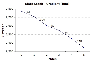
Slate Creek (Tributary of St. Joe River)
Old Miner's Cabin (Fritz Creek) to St. Joe Confluence
| Difficulty | IV-V |
| Length | 7.9 mi |
| Avg Gradient | 85 fpm |
| Gauge | St Joe River at Calder, Id |
| Flow Rate as of 1 hour | 875 cfs |
| Reach Info Last Updated | March 20, 2011 |
Overview:
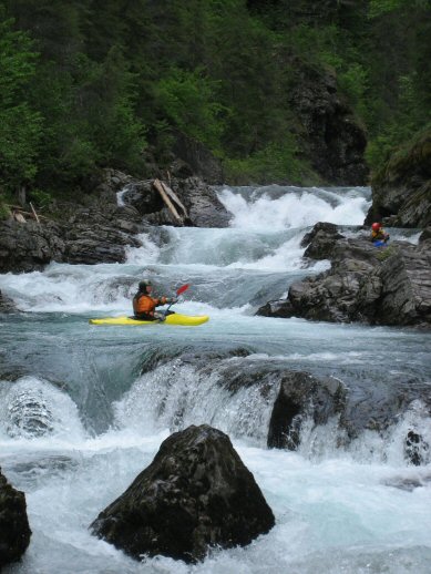
Slate Creek runs through a very deep and steep canyon with a narrow and channelized stream bed. The rapids are mostly slides and steep ledge drops into very sticky holes. Logs are always a serious hazard, so don't run anything blind. Plan on plenty of out-of-boat scouting. The most difficult rapids can be portaged.
Season:
The section is generally runnable from early April to mid June, but the run off in the area varies greatly from year to year. Snow may impede access in the early season. Check with Avery Ranger Station for current conditions on the road numbers mentioned in the logistics section below.
Maps:
The following maps are highly recommmeded:
Forest Service - St. Joe National Forest / Coeur d' Alene National Forest.
USGS - Mastadon Mountain 7.5 minute quadrangle.
Logistics:
From Interstate 90, exit at the Wallace, Idaho visitor's center. Work your way south through town following Placer Creek up a small canyon to road 456 (Placer Creek Road). Take 456 over Moon Pass (4,931') and down the N. Fork of the St. Joe to the town of Avery. From Avery, go roughly 7.5 miles downriver, past the Avery ranger station (not to be confused with the town of Avery) about 1 mile to the Slate Creek bridge takeout.
To get to the putin, take road 225 directly north of the Avery Ranger Station (look for the garbage dumpsters opposite the ranger station). Here the road climbs a steep open hillside to the canyon rim. Watch out for logging trucks on this section--they will crush you!!! On the rim, a large powerline crosses the canyon. Here the road forks and begins dropping. Where the
...Jun 11, 2013
Ran it May 4, 2013. We didn't check the gauge but it seemed like a good level. We portaged a couple ugly pour-overs and triple drop. Otherwise, it was great. Had a GoPro attached to my head. Here's the footage:
May 15, 2009
Ran it 5/14/09 with big smiles. Triple drop now has some wood hanging into the river just below the first drop. Lacking a saw, we could not remove them. Everything else boated very clean. The water level looked higher than pictures posted here, but the holes weren't incredibly sticky. Less water might possibly make them more abrupt and more sticky...any thoughts?
Jul 4, 2004
Todd & others, your new pics of Slate at considerably lower level than when we ran it clearly shows the dramatic difference the run is. The lower flows make each drop very distinctive, while at the higher flows they kind of blend together in a whitewater malestrom! Cool run either way. Thanks for the pics!
Mick
May 3, 2004
The painted gauge on NE side of bridge on piling is somewhat deceptive: If the Joe is quite high, so it will reflect on the gage as the backwater may falsely elevate the gauge even if Slate may not be running high. On the other hand, we ran Slate Sat 5/1/04 when the gauge was dry, well below 0 and the Joe was 4760cfs, yet Slate was similar in nature to when gauge read 1 ft? Difficult to say what the gauge really means.
Mick
Jan 1, 1900
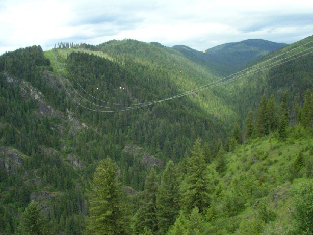
Looking down into Slate Creek from top of canyon.
Ruins of miners cabin at Slate Creek Put in.
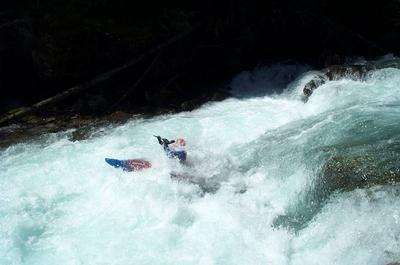
Kevin hand paddling Slate Creek.
Looking up at triple drop. Low water.
Looking up at triple drop from bottom. Low water.
If the water is this deep under the bridge, Slate Creek is runnable.
Bad place to encounter a fully loaded logging truck.
Typical pour over on Slate Creek.
One of the drops n Triple Drop. I can't remember which. The bottom drop was about 8 to 10'. Low water.