Tye
3. South Powell Island Rd (off US 29) to James River(Lower Tye)
| Difficulty | I-II(III) |
| Length | 9.4 mi |
| Avg Gradient | 11 fpm |
| Gauge | Tye River Near Lovingston, Va |
| Flow Rate as of 3 hours | 12 cfsbelow recommended |
| Reach Info Last Updated | March 2, 2026 |
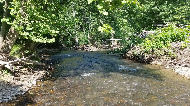
The Lower Tye is a great option for those looking for some mild whitewater in an undeveloped and fairly scenic setting. This section is popular with everyone from family floaters to inner-tubers. The usual hazards (foot entrapment, wood or 'strainers' in the flow, etc.) apply, but generally the river handles a wide range of flows.
This section is the sight of an annual downriver race and family-friendly gathering put on by Nelson County Parks & Recreation and the Nelson Area Paddlers. The race is usually the first weekend in May.
Take-out: You have at least two options for take-out points.
1. The first option - making for a shorter trip - is the Falling Rock Road (Rt. 654) bridge. There is some parking along the road on the river-right side of the bridge. This can also be used as a put-in point for a trip down the lower part of this stream reach.
2. The lower option - making for a longer run - is to take-out at the confluence with Rucker Run. The coordinates used on this webpage correspond to the Rucker Run confluence. Be aware that the access to this spot is unclear. There have been some issues with access here and reportedly law enforcement may have warned - or ticketed (?) - paddlers trying to cross the field from the river to the parking area, which is actually adjacent to the bridge over Rucker Run. Please respect private property and do not even think of driving across the field between the road and the Tye River.
Put-in: There may be a few options for put-in access as well
1. The put-in coordinates used for this webpage are on South Powell Island Road. Stay away from areas that are posted against trespassing and use judgement. Some folks access the river at a point known as 'hippie hole' along this road.
2. There is private access at the end of South Powell Island Rd. that is closest to Tye River Road. You may need to ask permission to launch here, and park in the appropriate location designated by the landown
...River Access: Falling Rock Road (Rt. 654)
Take Out - Cedar Creek Road Bridge over Rucker Run
Aug 19, 2020
'Minimums' are often a function of the boat you're paddling and your expectations. We ran this from 654 to Rucker Run on August 18, 2020 at 60 cfs and had just enough water for an enjoyable float in a tandem touring canoe. A few scrapes unavoidable, but no dragging required. The takeout at Rucker Run is a steep, brambly mess, though.
Apr 27, 2017
We ran this stretch today from US 29 through the confluence to the Wingina boat ramp on the James below JRSP. The Tye was at 341cfs when we put on and 304 cfs when we took out. I think it would have been perfect with just a little more water to pad a few of the rough places. I wouldn't recommend this run below 300 cfs because you need the extra water to get you to the confluence in a timely fashon. At this level, most of the river was made up of class 2 wavetrains with several nice class 3 spots in between. This stretch is fast, secluded and fun. Total run time was @7 hours with a couple of extended breaks.
Jul 6, 2011
At the begining of June 2011 we did this run at 76cfs and it wasn't bad. Did it in my Old Town 158 and had no problems and the fishing is GREAT !!!