KF
Kirsten Frickle and Mike Sweeney
May 10, 2015
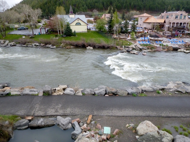
one of the many waves in town ~800cfs
| Difficulty | II-III |
| Length | 32 mi |
| Avg Gradient | 32 fpm |
| Gauge | San Juan River at Pagosa Springs, Co |
| Flow Rate as of 1 hour | 26 cfsbelow recommended |
| Reach Info Last Updated | April 27, 2026 |
Colorado River Access American Whitewater’s Colorado River Access Program works to improve river access and public safety throughout the state by working with landowners and managers, paddlers, law enforcement, and lawmakers to understand Colorado’s river access laws and the ongoing threats to public safety. Our primary goals of this [...]Read More
IMPORTANT: Please visit the Southern Ute Indian Tribe's website for regulations on boating and fishing the San Juan River within the SUIT reservation boundaries. The Tribe permits non-Tribal members to float through reservation lands on the Animas River, Los Pinos River, the Piedra Rive, and the San Juan River. However, only people who are actively fishing (and with a valid fishing permit) using a small craft may put-in or take-out at specified fishing access points. See below for additional information from boater, Josh Stone. This run can be divided into multiple sections, with a short upper section that ends at Yamaguchi Park upstream from SUIT lands.
Josh Stone reports:
Alright, I've only done this run about 4 times, so this is what I have to offer. First, let me say this is probably one of the prettiest non-permited runs in Southern Colorado/Northern New Mexico that offers 'easy' whitewater. I wouldnt exactly call this a beginner run due to the fact that the water is very, very cold and once you are in the canyon, trespassing signs restrict you from getting out of the canyon. I have done this stretch from 900 cfs to 1800 cfs, and I find that the more water the better. I would imagine that around 2500, things start to get a little flushy and hairy.
The put in for this stretch is at the malt shop (good ice cream!) after you cross over the bridge that crosses the river on the left. Once you put in, you are on the man made course through town. This course is pretty continuous II+ waves and holes which offer some play at good water levels. If you dont feel like doing the whole run, take out at Yamaguchi Park (only about a 30-40 minute paddle). Past this bridge, the river meanders over some easy shoals and you start to recognize some canyon walls shooting up as you leave ci
...About a 50 yard walk to the river from the parking. Popular put-in for tubers in the summer.
Takeout at Yamaguchi Park- short, fun float thru town to this point.
Rest area- this beach is provided by the private landowners as an rest area for the long stretch of private property below Pagosa Springs. Keep it clean so we maintain access!
3-4 ft high waterfall off a manmade ledge, was fairly straightforward at 540cfs, but imagine it gets more difficult at higher flows. Scout or portage from river left.
3-4 ft high waterfall off a manmade ledge, was fairly straightforward at 540cfs, but imagine it gets more difficult at higher flows. Scout or portage from river left.
Roughly 14.5 miles from the put in behind the malt shop. Unmarked pull-out but room for lots of cars with parking on either side of the road. Two sort of gravel ramps/accesses on the east side of the road with most parking on the west.
May 9, 2026
We ran this in two rafts (14 foot and 15 foot) at 540 CFS on Mother’s Day weekend. We put in at Pagosa Riverside campground where we camped the night before. I would definitely recommend the spot which had hot showers, dishwashing, and $35 for camping by the without much road noise. Above town for a few miles the River was shallow and we got hung up a couple times on sleepers and gravel. There was a lot of evidence of the flood from October 2025 here rock piles and eroded banks. The town section was great with some good class two fun. Seems like there are about 30 or so of these man-made ledges throughout the run down to Trujillo Road at mile 16. The flood had washed out some of them and made them more like rapids with tongues, some of the ledges had recirculating energy, enough to pull the raft backwards a bit, but not keep it. At this flow we got hung up a couple times in the drops one time getting pinched between two rocks and another time when there was a rock directly below the drop that caught our nose. We had done this run one time before at 1000cfs and this was considerably more challenging at 500cfs both because of the boniness and the way the river had changed due to the flood, whole trees in the river at times. Lunch spot is beautiful, about 6miles from the takeout. Constant attention was required to find the river channel, dodge rocks, find sleepers, and scout the rapids from the boat by standing up. We had previously known about Llama falls the 3’ waterfall. It’s similar to others of these ledge drops, and at this flow there were a few of this magnitude at 3’ or so that make your frame slide forward. It’s exciting in a raft and fairly straightforward. This run is exceptional, we’ll be back!
Jul 8, 2023
We put in behind the malt shop and floated to the take out in 4:45 with a fair amount of paddling. The canyon was beautiful and had a lot of non-stop class II action. The description from 2004 was nice to read beforehand, but honestly struggled to match it up with the river. I could not tell where that bridge rapid was and it totally neglected to mention a 3-4ft high vertical waterfall drop at 37.163451, -107.038981. Scouting is very recommended here and it is portage-able river left at low flows. Unsure about higher flows. It looks very intimidating, but is a straight line across the river so lining up the drop is easier than the dozens of U-shaped dams/man-made drops above and below. Staying perpendicular to the holes below these was a challenge with the curvature of the drops. We did have one paddler flipped in a hole below one of these dams and the hole kept his boat for ten minutes before we portaged back upstream and rammed it out with another boat.
We were in packrafts and I would say 500 is a good bottom flow for this stretch. We were having to scoot across some shoals and riffles, but if you knew the river, you might be able to avoid them.
One other aspect of the 2004 report that was lacking was mentions of all the islands that the river splits around. There's probably about a dozen and the way around is not always clear. Some channels look promising at the head of the island, but looking back up from the bottom, they're either very shallow or have some wood.
Overall, really fun float and good step up for Class II boaters looking for some class III. It's not a casual float and sure higher water is trickier, but we enjoyed it at these flows. Looks like levels have dropped into the 300's only days later though so might be over till next year.
Takeout for a 14.5 mile float- 37.12610770472159, -107.05186362767749