Cedar
Palisades-Kepler State Park (PnP)
| Difficulty | III |
| Length | 0.59 mi |
| Avg Gradient | n/a |
| Gauge | Cedar River at Cedar Rapids, Ia |
| Flow Rate as of 50 minutes | 7640 cfs |
| Reach Info Last Updated | January 16, 2024 |
Update 2020 - Strongly recommended to get in touch with a local boater that knows the flows and area for here. Alot has changed over the years, so the previous info below may or may not be accurate. This a deteriorating dam that is constantly changing. It's the site of many drowings/near misses (2 drownings in 2019). You need to know where to go and not go, that changes with water levels too.
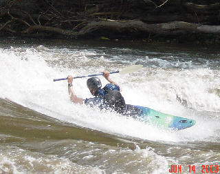
At the right flows there is a wave with some serious hazards around it (according to local paddlers). Rebar, fresh rock and metal coffer material is present. Cliffs on both sides, pushy water, and other associated hazards should limit this area to high intermediate and expert paddlers only. The majority of the flow goes through the river right dam-breach which creates reactionary waves, haystacks and other boat-swampers.
Update - 03-27-11: Two play areas are described below; the 'Channel Side' on the west or opposite side of the river from the put in (pictured above). And 'The Hole' which is downstream from the put in and created by the intact portion of the dam. On the river left side the hole is playable. Get more than a boat length or two towards the middle and it gets terminal.
Don't be tempted to run the center slot of the dam or play below it as there are a multitude of snags and other nasties just below the surface.
Aug 31, 2020
Get in touch with a local boater for this one. There's lots of nasties hiding all over. It can be fun when its working, but it seems to be super fickle with flows as to whether or not it actually forms. A local boater that knows the flows and area is best.
Feb 7, 2008
Check out the Cedar River Environmental group at http://www.thecregproject.org
CREG is a watershed non-profit group focused on the long-term sustainability of the Cedar River and its tributaries. Headquartered in Cedar Falls, Iowa, the group arose from the Cedar River Festival, the longest active river clean-up in Iowa.
Jul 5, 2004
Recent flood waters have romoved the portion of the old dam that was responsible for forming the large wave-hole that is shown in the photos. A wave does still form in the south breach of the dam at the flows listed above, however, it does not get steep enough to surf a boat shorter than 8ft and even then it's a slow ride. No more fast carves and no more 360s. Also, the eddy that used to pull you back up to the dam from at least 200 yards downstream on the river left side of the south breach now only extends ~30 yards below the dam.
