Hood, E. Fork
Sherwood Campground to Hwy 35 Bridge
Mar 5, 2022
Nice run today, picnic area to bridge. We're not launching up at the campground. It felt juicy and fast with the calculated East Fork flow on Pat Welch's page dropping toward 1,000 CFS tonight. That calculation is the Tucker flow minus the West Fork flow. I learned about another gauge--a stick gauge on river left, upstream from the next bridge downstream from the takeout (Baseline Road). Today's flow on that gauge was ~12.25. Apparently it's good in the high 11's to low 12's on that gauge.
The wood situation is basically the same as last year, with one portage for us in the last part of the run. We walked where the river breaks to the right of a major log jam--and there's more junk hidden behind it, though some might choose to run that woody junk. We walked it by dragging our boats down the channel that goes left of the log jam. The other wood of note is shortly before the takeout, a river-wide log that can be ducked on the right, at least at today's flow. There are lots of other pieces but nothing sneaky or impossible to avoid.
May 6, 2013
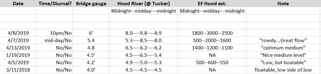
Flows notes. There's a new gauge on the West Fork, here: http://www.nwrfc.noaa.gov/river/station/flowplot/flowplot.cgi?id=WFHO3. It reads lower than the Tucker gauge by something less than a foot. The flows in the East fork increase all day long on hot (over 80 in Portland) and sunny days, esp if there's an east wind. When the AW site says it's too low at Tucker (under 5 feet but close), go late in the day.
May 6, 2013
Wood update. Two new pieces in the bottom section, for a total of three cross-river obstacles, all in the bottom mile. Specifics: one portage right, one duck right, and one hop in the middle, I believe in that order. We've started taking out at Rouston Park which is 3/4 of the run mentioned above and misses the worst wood. There are still trees to avoid but they are visible with routes around. Rouston is gated so if the gate is closed you are still going to the bridge.
Jul 4, 2011
If you run bridge to bridge there are currently two logs to portage. If you put in at the trailhead you miss one, and if you takeout at the first pullout on the right above the takeout bridge, you will miss the other log. It is worth doing. Scout the takeout though, because you have to beat through a thicket and it sucks to do it with a boat when you don't know if you're in the right place.
The first half of the run is more technical and steeper. It is continuous class IV within 1/4 mile of the launch. If you blow one move you better make the next one! The whole thing is read-and-runnable for suitably skilled boaters. Lost boats go a long way even at low water. There is not a single pool but there are eddies. There's more brush/alders on the 2nd half of the run but it's all currently passable. Locals tell me that the rocks and wood shift every year. Low water is a good option for a first run. Apparently some of the holes are wicked at high water.
Usually not runnable in July! We had a late melt this year. The East Fork runs later on high snowmelt, the West Fork has a lower and smaller snowfield and runs more from rainfall. The Tucker gauge shows both forks combined and does not tell you which fork has the water.