Fox (Illinois R. trib.)
C) Batavia Dam (PnP)
| Difficulty | I-II(IV) |
| Length | 0.15 mi |
| Avg Gradient | n/a |
| Gauge | Fox River at Montgomery, Il |
| Flow Rate as of 37 minutes | 566 cfslow runnable |
| Reach Info Last Updated | February 4, 2025 |
Quick Facts:
Location: Downtown Batavia, IL (Approximately 40 miles due west from downtown Chicago).
Shuttle Length: Carry up (Park-and-huck/park-and-play)
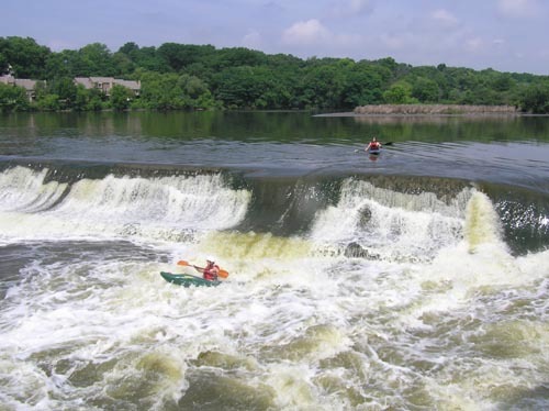
Character: City surroundings. A dam on a fairly large watershed river (therefore almost always at least some semi-playable flow) provides local boaters moving water practice, and (with caution) a IV-ish slot to run.
As of August 7th, 2023, Batavia City council voted in favor of a plan to remove the failing dam, replacing it with step-down structures which will maintain present pond-height and enhance whitewater opportunities at this site. This is merely the first step in the process, as the proposal has to be approved by the IDNR and ACE (Army Corps of Engineers) before it can proceed.
UPDATE (2024.10.01): Showing how slowly these things move, more than a full year after the above-mentioned approval to remove the dam, the council has now proposed (for sometime in 2025) a feasibility study. Which means no removal nor construction of rock-arch 'step-down structures until at least 2016. Details here: dailyherald.com/20241001/news/batavia-city-council-continues-looking-at-dam-removal/
General Overview
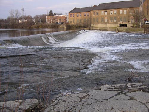
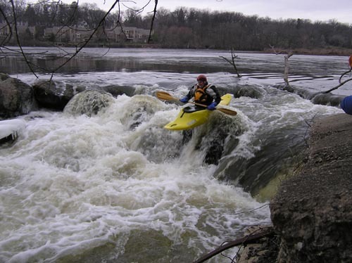
An 8' dam (sloping face, runnable in a number of different spots at different levels, for varied thrills) is followed by good currents. At high water, a river-right bedrock slide (shown in the foreground in the 'feature photo' above-right) provides a bit of a 'rapids-running' opportunity, while river-left route provides a quick class IV-ish plunge. This slot is prone to catching debris, thus should always be scouted before running. As of this writing (2006.02.26) it is completely open/clear.
While this entire area is not generally noted for any specific playspots, it does have its proponents as a convenient spot for locals to
...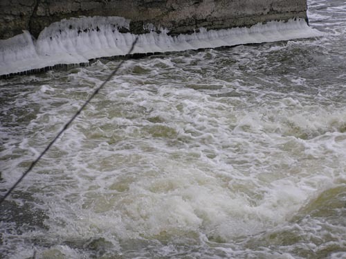
Any runs of 'The Corner' have to be done with caution because of the wall below. While always at least a mild hazard, in winter the hazard may be more extreme, as an ice shelf will form. Being pushed toward it (in or out of your boat) you are likely to get stuffed under. It is highly recommended (especially for any winter runs) to have someone at the ready with rescue gear and the training to know how to use it.
Just to the right of 'The Corner' lies 'The Slide'. The cement of the dam has a fine dip and lip, which will launch you into a great 'boof' into the pool below. It may be a bit difficult (from your boat, above the drop) to tell if you are lined up correctly. Take careful note of 'markers' to hit this spot!
At river right, the dam abuts bedrock on shore. At moderate-to-higher flows, this will form a sweet roundhouse 'exit-ramp' slide into the pool below. A few minor waves may form here at certain flows.
Far river left, the dam is a broken jumble of rock, forming a short class III-IV chute. At the base of the flow water piles up into a wall sticking out into the flow from the vertical wall of a building (forming the 'riverbank' on the left). Solid boating skills may be needed to avoid hammering into this wall and flipping.