Toccoa
Sandy Bottoms to Tilley Bend
December 31, 2005
| Reporter | Robert Butera |
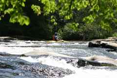
Self Shuttle! Today I did my first self-shuttle of the Toccoa. It was painless, and makes the river twice as fun, experiencing the rapids below the Aska road takeout. See my other post from today about those rapids.
Park at the intersection of two dirt roads: Shallowford Rd and Old Dlal Rd. This is where you take the right turn towards Sandy Bottom if running the usual shuttle from Aska road.
From this point, you can walk about 0.6 miles downhill along Old Dial Rd. towards Sandy Bottom and put in when you get to river level, just after the USGS gauging station.
The takeout is a spot on the Toccoa known as Tilly Bend. There is a sharp bend in the river - you will suddenly see houses with boat docks ater the bend. Take out before the stream that feeds in on river right. There is an ATV trail above the river, and it is an easy 0.4 mile uphill walk back to the aforementioned intersection. The trail at this point parallels the river -- walk downriver and the trail will turn right and paralllel the aforementioned stream.
It is probably a good idea to take the 10 minute hike from the intersection down to Tilly Bend to know what to look for. There are several trailheads near this intersection (including the Benton McKay) -when facing the right side of the road, take the rightmost one that heads down, initially paralleling Old Dial Rd. If you head along a ridge you've taken the wrong one!
The hike back up to the car was 13 minutes, and the flatwater paddle after the rapids stopped was under 15 minutes. Total trip time from leaving the car to arriving back was 3 hours, including a 20 minute lunch stop and very little river play.
The hike back, while 0.4 miles uphill, is not steep -- easier than hiking out of Woodall on the Chattooga, even if longer.