Saint Vrain Creek, South
01. Ceran St. Vrain TH to Middle St Vrain Confluence(Upper SSV)
| Difficulty | V+ |
| Length | 6 mi |
| Avg Gradient | 230 fpm |
| Gauge | South Saint Vrain Near Ward |
| Flow Rate as of 1 day | 17 cfsstale data |
| Reach Info Last Updated | December 12, 2018 |
This is an obscure Class V+/VI- wilderness run. It has been paddled a couple of times but has never seen regular use.
Mostly I am putting this in the AW database to bring attention to that fact that it exists and that will help it get cleared of wood.
Also, if this has enough water the lower section definately would have enough and they could be combined for 10 continuous miles of Class V creeking!
The shuttle is super easy, and the run will definately get enough water in a decent year (probably 300 CFS or so at peak).
The rapids at the put-in and soon after look promising, but then the gradient peters out and there is lots of wood, much of it put there as bridges by fishermen. Soon after the trail leaves the creek the gradient will pick up to continuous Class IV with lots of wood for about a mile.
There will be a very short calm strech before the bottom drops out.
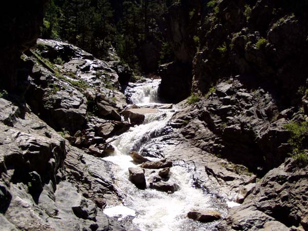
At this point, there is a super intense bedrock gorge that drops at a rate of 400 to 500 fpm for about 1/4 mile. Then the gradient will remain fairly steep for the remainder of the run, 300+, but it won't be gorged up.
Lots of wood!
Should someone scout this out or do some wood cleaning, the best way to get in there is to mountain bike from the trail head, the trail follows right next to the creek through the easy stuff, and then climbs out into the hills on river left right before the gradient. Once on the jeep trails that climb away from the river keep taking the trail to the right to parrallel the river up on the edge of the canyon and you will definately be able to tell where it gorges up!
This is a great bike ride!
Extensive pics of the crux section...
To Get There: The takeout is the put-in for the normal ssv run, at the confluence of the south and middle forks of the creek on Hwy 7 west of Lyons. To get to the put in continue driving upstream until
...No trip reports yet.