| Difficulty | II-III |
| Length | 2.9 mi |
| Avg Gradient | 37 fpm |
| Gauge | Rock Creek at Sherrill Drive Washington, Dc |
| Reach Info Last Updated | March 4, 2026 |
River Description
This is the best section of Cabin John Creek, and it is an excellent paddle. The first half a mile has frequent class IIs, alongside first River Road and then Seven Locks Road. There is one island a few hundred yards below River Road; the left channel has more water. Where the creek turns sharply left and passes below Seven Locks Road, just past the pipe that spews out an uninviting brown waterfall, there is a short but bouncy class II+ drop, best run on the far left. The rapids then ease up to class II-, for the middle third of the trip. The creek passes beneath the Beltway, and Booze Creek enters soon afterwards, through a garishly-grafittied tunnel under Cabin John Parkway. Then, as Cabin John Creek enters an attractive semi-gorge, the gradient and rapids pick up. For a half mile there is one long class II+ or III- rock garden after another, with one solid class III. And there are lots of good surfing waves and holes.
Take out on river left just before the culvert under the C&O Canal, after passing beneath Macarthur Boulevard, Cabin John Parkway and Clara Barton Parkway, and drag your boat up the wide grassy slope to the small gravel area on the shoulder of Clara Barton Parkway. (Alternatively, you can paddle under the C&O Canal -- if the water is not too high -- and a quarter mile down to the Potomac, and take out a mile downstream at Sycamore Island, but this results in a much longer and steeper carry. Also, there is about 6 inches less clearance on the downstream side of the culvert than on the upstream, so donÂt go under the Canal unless you are sure you can get out!)
To shorten the shuttle and avoid a possible ticket for illegal parking, leave your car in the large parking area on Macarthur Boulevard just east of the single-lane bridge over Cabin John Creek. From the Canal take out, follow the wide grassy trail under Clara Barton Parkway, and, a quarter mile later, up the stairs to Macarthur Boulevard.
River Features
Put In
Access PointDistance: 0 mi
495 Pile Up
HazardDistance: 1.25 mi
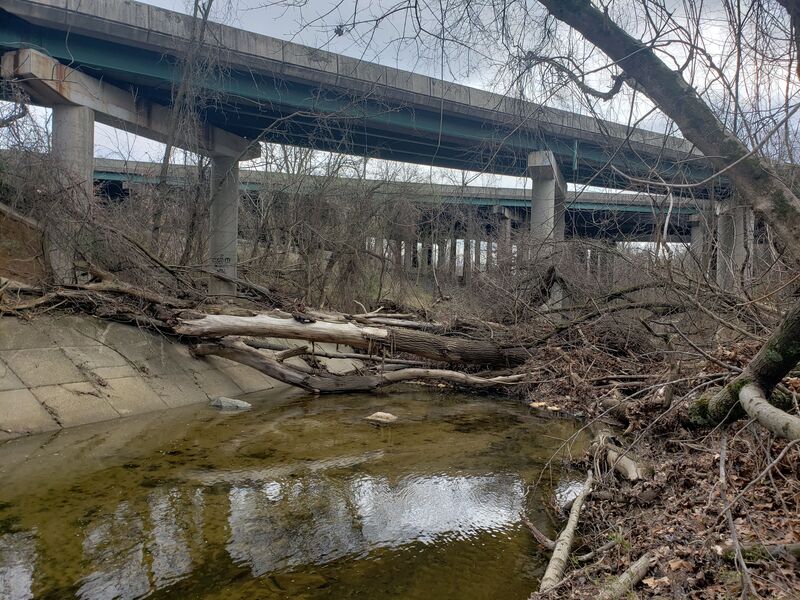
The pylons for the beltway have collected numerous trees stopping the flow, mirroring the rush our traffic above. Typically portaged on the river right side.
Take Out
Access PointDistance: 2.9 mi
Trip Reports
Log in to add a reportAC
Alford Cooley
Dec 26, 2020
From the Canoe Cruisers Assn - I have records of seven runs. I participated in four of these. The posted stream description is excellent, but the algorithm today (25 Dec 2020) indicating that the current 315 cfs is insufficient - is way off base. We use the USGS gauge on the NW Branch Anacostia at Colesville as our indicator - multiply its reading by 0.86 for volume at the usual River Road put-in. Our records from 2007 to 2020 reflect descents at the following NW Branch volumes: 218, 90, 180, 330, 263, 309 cfs. All had ample water. The picture of the big strainer under I-495 is one of the configurations of what fetches up under there. Sometimes there's nothing. But whatever the strainer there, it's easy to see and at normal levels, it is not hard to stay upstream of and portage right, if necessary. Several trip reports can be found at CCA's website - www.ccadc.org - Trips - and go to 'search' for Cabin John Creek.
BR
Brad Roberts
Mar 14, 2008
From the Monocacy Canoe webboard:
Posted by MarkB on August 17, 2004 at 16:48:39:
In Reply to: Cabin John Creek? posted by Brad on August 17, 2004 at 12:56:44:
I did it several years ago. It comes up and goes down pretty quickly, so you need to be opportunistic go get it. Putin at River Rd near the fire station. Takeout at Lock 7 or 8. From what I recall there were several strainers, one of which (a large fallen tree spanning the creek) looks semi-permanent. I hiked it last year and it had not budged.
Other than the strainers, it's a fun run and worthwhile if you can catch it up. Small, twisty, with not a lot of flat water. No major hazards other than downed wood.