Cedar Creek (Adams Co.)
5th St to Bob Bangart Park on Bottom Road (1 mile)(Bob Bangart Creek)
| Difficulty | II-IV |
| Length | 0.5 mi |
| Avg Gradient | 35 fpm |
| Gauge | Bear Creek at Hannibal, Mo |
| Flow Rate as of 1 hour | 2 cfsbelow recommended |
| Reach Info Last Updated | April 2, 2019 |
This is a great whitewater run that is VERY uncharacteristic of this part of Illinois. The pics do not do this creek justice.
While you can run a 4 mile section if you want, we generally choose to get our kicks by hitting the last mile (as listed here) starting below the 5th street bridge near the entrance to Parker Heights park. You can access the creek from the south side of the bridge by cutting through the woods from the railroad tracks.
This is a smooth rock bottom creek with some sediment in the pools, but the rock bottom makes for some great ledge drops and surfable features and holes. At low water this is a great learning run with forgivable features. No undercuts or really sharp rocks, the ledge drops are forgiving with recovery pools and a few (very few) eddies. The best surfable features have no eddy service, which is a drawback, but still a great creeking run.
The best way to tell what to expect is to drive into the park and stop at the only large clearing in the trees at the side of the creek. The opening is just west of an overpass that spans over the park and you can see a diagonal concrete ledge that joins with an irregular rock surface on river right. That drop is called 'Pecker's Knob.'
If the ledge is mostly still visible and there is still somewhat of a drop, it's pretty low and I'd rate it about a class II+.
If the diagonal ledge can't been seen except for the concrete abutment on river left, then thats your class III+ with anywhere in between being a class III.
The class IV comes into effect when the diagonal ledge is all but gone and the water is flowing over the abutment on river left. this creates a nice hole at the bottom and another one on the last ledge.
From this first diagonal ledge, it drops down to a long slider and another ledge with a hole and pool at the bottom which curves left next to a cliff face on the right. There is an eddy on river right before the cliff face if you need to rest.
...Taking the above write-up literally ('you can run a 4 mile section if you want') means put-in at Koch's Lane (just west of N.36th/CR800E). There are biking/hiking trails along the creek (which can be used for bike-shuttle) extending all the way from Koch's Lane to our listed take-out.
Drainage area there is just over 2 square miles (extremely tiny), and the gradient upstream is 60 FPM. Such a small and steep drainage area means runoff will be extremely quick. Runnable occasions are likely to be mere hours (or less!), during and immediately after heavy rains.

Drainage area at our listed (short run) put-in is 5.73 sq.mi. (as calculated via USGS StreamStats Beta software).
The nearest USGS gauge (on as similar as possible drainage area) is ~20 miles due south in Missouri, with drainage of 31 square miles. Flow here might be (on average) just less than 1/5th (0.18387 times) the reading on this gauge.
However, any online gauge will be nearly worthless for catching this run! USGS gauges update online usually just once per hour, and when data is posted it is already 20-30 minutes old. By the time you see that data, gather your gear, get to the creek, gear up and get on ... you've likely missed the peak flow!
It is likely the only realistic way to catch this run is (1) you have to already be within a half-hour or so drive from the creek, (2) you have to be watching weather radars online, (3) you need to have your boat and gear packed and ready to go, (4) you need to roll out as soon as the heaviest rain has passed.
Access the creek from the south by cutting through the woods from the railroad tracks, to put-in below the 5th street bridge.
Take out where the cliff ends on river-right.
It is possible to continue downstream, but it's uneventful, and difficult to find a good spot to takeout.
Jan 1, 1900
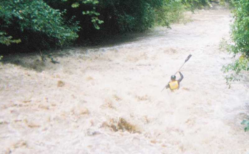
This was run roughly 45 minutes after a torrential downpour that dropped around 3 inches of rain in an hour... the pics do not do this run justice... believe it or not Adam is paddling a 9 foot dagger zydeco rec kayak with a 220cm walmart paddle ...needed an extra kayak for him and it's all we had... way to tear it up!
Jan 1, 1900
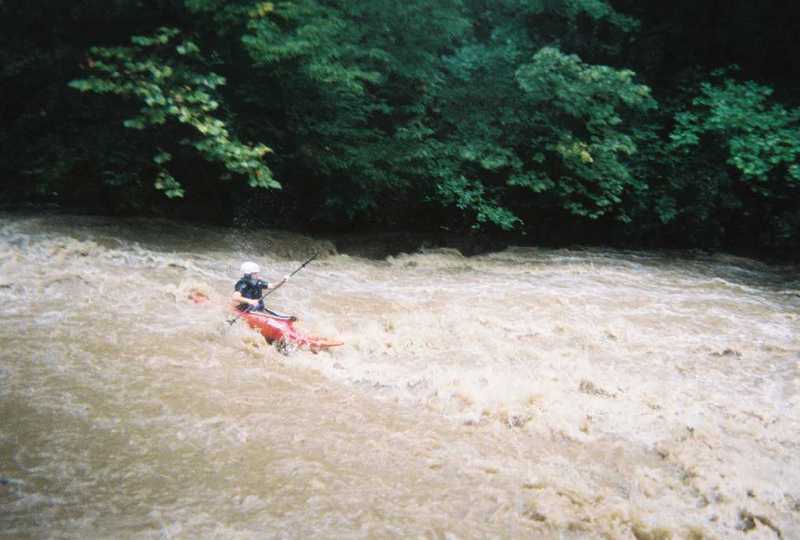
Broke my paddle the day before and had to use a 220cm touring paddle from walmart, definitely a trip.. but got the job done. This is a pic of me comming down over Pecker's Knob, the drop is usuually a little 3 footer, but there was so much water that it washed out a lot of it. You can see a bit of water pouring over the ledge on the far bank just about where my left paddle blade is, but most of the feature was a wash, there is a 20 foot slide just down stream from this drop.
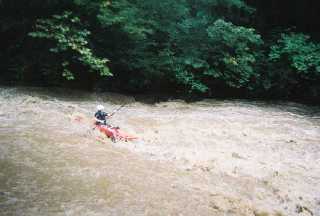
This is a shot of Clint (foreground) and Mark comming around the bend just before dropping over Pecker's Knob.
Mark (foreground) and Adam are getting in line to take Pecker's Knob.