Little Susitna
1. Upper
| Difficulty | IV+ |
| Length | 5.5 mi |
| Avg Gradient | 158 fpm |
| Gauge | L Susitna R Nr Palmer Ak |
| Flow Rate as of 27 minutes | 787 cfsrunnable |
| Reach Info Last Updated | September 21, 2005 |
Put-In
The put-in for the Upper Little Su is as far up the Gold Mint Trail as you care to carry your boat. To reach the Gold Mint trailhead parking, turn off the Glenn Highway north of Palmer at milepost 49.5 onto the Palmer - Fishhook Road. Follow the Palmer Fishhook Road to Hatcher Pass Road, and head north toward the Pass. Turn right just across from the Motherlode Lodge. The hike is never too far from the creek, but views are rare due to the brush. Four miles of carrying your boat should take around 2 hours, to a spot where the trail descends to the creek. The Upper Little Su has been run as high as seven miles in.
Take-Out
Take out at the Gold Mint trailhead. Alternately, if the carry and the paddle out is not enough, continue down the Little Su.
Description
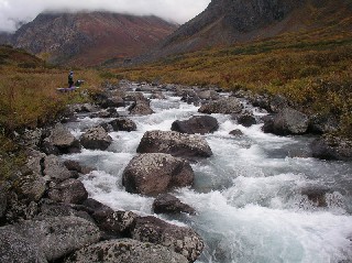
The Upper Little Susitna offers a hike into a beautiful area, and a paddle out on a technical, continuously interesting creek. The view from the Upper Mint Valley is spectacular, with the looming Montana Peak and the varying Mint Peaks. The water is cold, directly off the Hatcher Pass area snow melt and the Mint Glacier, and is azure blue at low to medium levels. The rapids are pool drop boulder gardens, and most can be easily boat scouted.
If you're looking for more of the same, check out the following Talkeetna Mountain creeks, from easiest to hardest:
Guardrail stretch of Willow Creek
No trip reports yet.