West River
5. Rock River to the Connecticut River((Newfane))
| Difficulty | I-II |
| Length | 11.2 mi |
| Avg Gradient | n/a |
| Gauge | West River Below Townshend Dam Near Townshend, Vt |
| Flow Rate as of 45 minutes | 3.78 ftbelow recommended |
| Reach Info Last Updated | April 30, 2018 |
Dummerchuck - The West Dummerston, Vermont, Section of the West River (South of Townshend Dam)
Directions:
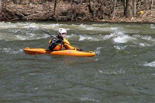
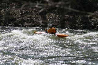
This section runs for 19 miles, from the Townshend Dam to the Connecticut River. There are numerous put-in and take-out spots, as this river follows Route 30 as it runs into the Connecticut River. The first 11 miles or so mixes sections of flat water with class 1 rapids and occasional, simple, class 2 rapids.
The section most often run by whitewater kayakers begins at the confluence of the Rock River and the West River. This confluence is located two miles upriver from the Dummerston covered bridge on Route 30. There is a large parking area on the right hand side as you head northwest on Route 30 at this point. There is one other bouncy class 2 rapid just upriver from this point as well.
Many paddlers, looking to play for an hour or two, put in at the West Dummerston covered bridge and take out at a small dirt road that is across from the convenience store/gas station on Route 30, about a half mile down river.
The normal takeout downstream is Deyo's Hole, a swimming hole about four miles downstream from the Rock River confluence. There is a small parking area on river right there (the left side of Route 30 as you head towards Brattleboro). To identify this from the river, look for a large rock face/cliff that is about 15 feet high on river left. It is a frequent jumping-off rock at the swimming hole. The exit is just across the river from there.
River Description:
Although this is overshadowed by the Jamaica section of the West, this section is not to be ignored. Water levels here are driven by the Townshend Dam, which is downstream from the Jamaica/Ball Mountain Dam, and this section of the river is runnable far more frequently. The dam is run by the Army Corp of Engineers, and the only scheduled releases are the three a year that
...