Sixmile (& E. Fork Sixmile)
Seward Hwy along E. Fork of Six Mile to Sunshine
| Difficulty | V |
| Length | 9.3 mi |
| Avg Gradient | 43 fpm |
| Gauge | Sixmile C Nr Hope Ak |
| Flow Rate as of 46 minutes | 2120 cfsrunnable |
| Reach Info Last Updated | November 14, 2012 |
Once famous as the site of the 1895 gold rush, this creek is becoming increasingly well known as the gathering place for Anchorage paddlers and in recent years has been marketed as a destination for high-adventure commercial raft trips. The reasons are obvious: the quality of the whitewater is exceptional, the water is a beautiful, the scenery is breathtaking, the season is long, and it's close to Anchorage making it convenient for locals or those cruising through from out of town.
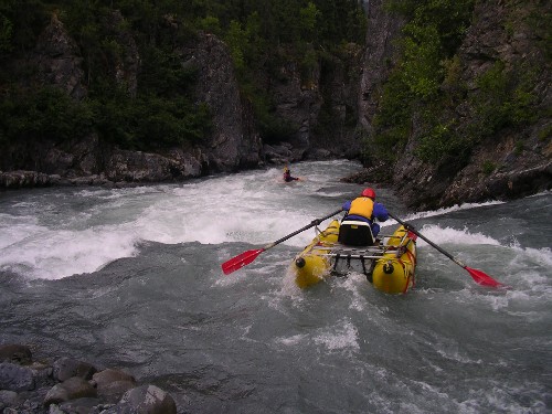
The run can be divided into two sections. The upper section is actually on the East Fork. Here the river squeezes through a narrow bedrock canyon, the first canyon which contains several fun class IV rapids, and although the road is close by you feel secluded down at river level. This short upper canyon ends as the river opens up at the confluence with Canyon Creek. This major tributary pumps up the flow considerably and from this point you're on Sixmile Creek. For the next few miles you won't find much action as the river bubbles along through class II, but as you enter the two lower canyons the intensity begins to pick up.
The second canyon begins just after Boston Bar, a beautiful site on the river recognized by a dramatic avalanche chute on river right. Even though the rapids are mild leading up to this section, the scnery is truly impressive. Just downstream the river squeezes between the walls of the short but fun second canyon. Generally regarded as class IV+ at recommended flows the drops come in quick succession before the river opens up again between the second and third canyons. This stretch between the two canyons is characterized by class II/III rapids and if you feel like you had your hands full in the second canyon, now is the time to take out.
The third canyon, generally regarded as a class V run, starts to build slowly in intensity but eventually you'll reach the first major rapid at Staircase. Here a large midstream bedrock outcrop and a distinct hor
...
A large pullout with a smooth walkway down to the river serves as the usual put-in for boaters running all three canyons. For a little over a mile and a half, the river rolls through easy and beautiful class I-II terrain making for a pleasant warm-up. Until you reach the confluence with Canyon Creek below First Canyon, you are technically on the E. Fork of Sixmile Creek.
This fast rapid guards the entrance to First Canyon. 17 Ender is a steep ledge immediately following a sharp bend to the left. A boater who wasn't heads-up could get pulled into this one before they realize what's happening. 17 Ender can be run down the gut, but for nervous kayakers or packrafters an easier line exists on the left at most levels. Immediately downstream, the river enters an impressive box canyon and squeezes through a constriction sometimes called Predator which features lateral waves and holes. I usually think of this sequence as one rapid and it could be class IV at higher water levels.
Note: A trail comes down to the river on the left directly above this rapid. Kayaks and packrafts often put-in here for a direct launch into the whitewater.
Below Predator, the short box canyon opens up and there's a large eddy on river left to collect yourself before Waterfall Rapid. Essentially, Waterfall is a broken five-foot ledge. At lower levels, small boats can dash far left to sneak around the worst of the hydraulic. At higher flows beware of the river driving into the right wall below the ledge, hence this rapid's alternate name: Wall Slammer. This rapid might earn a class IV-/IV rating at higher flows.
Just below Waterfall, the river rolls over a broad rock garden then pinches through a narrow gap in the basement rock. There is usually a hole and some boily water in and below the constriction. Beware of a dangerous undercut wall just downstream on river right if you're collecting carnage.
A few corners after The Notch, the river bends hard right and tumbles over an angled ledge across most of the river. This rapid has surprised and eaten a few boaters in its day. Run far right at lower flows to miss the hole. At medium flows and up, the hole washes out.
The confluence of E. Fork of Sixmile and Canyon Creek is a common access point for boaters just wanting to run First Canyon. There's no boat ramp and you must navigate a little brush to get to your vehicle from the river, so not particularly good access for rafts. It's great for kayakers and packrafters, however, not feeling up to the challenge of the lower canyons. You can reach this spot via a large dirt lot on the right immediately after turning onto the Hope Road. There's a bathroom here and a dirt road that curls down to parking beside Canyon Creek. Three-and-a-half miles of mellow and beautiful class II paddling follow.
This excellent river access is common for boaters wanting just to run Second and Third Canyons, which makes for an exciting 4-mile stretch of classic whitewater. Boston Bar is at mm 3.3 on the Hope Road. There is room for a dozen cars or so in the pullout off the highway and a bumpy dirt road takes you to a meadow with more parking. From here, a short-ish trail leads down to the waterside. After putting-in, you'll encounter a short section of warm-up rapids before entering Second Canyon.
Note: Boston Bar also functions as the headquarters/campground/music venue for the annual Six Mile Creek Whitewater and Bluegrass Festival
This ledge collects your toll to enter Second Canyon. A large hole guards most of the right side of the river, but a tongue on the left offers the path of least resistance. A bad run here sets you up poorly for The Nozzle, which is immediately downstream. At low water you can eddy out the left between Pearly Gates and The Nozzle, but at medium flows and above this eddy is a mess of boils and whirlpools. This is no place for a swim at those levels.
The Nozzle is arguably the crux of Second Canyon. At low water there are three distinct parts, each with its own strategy for success. Above 10.0' on the gauge it merges into a high-velocity sluice of massive waves and laterals. A large eddy on the left just downstream offers an opportunity to catch your breath. An easy trail connects this eddy to the road via a pullout at mm 3.7, allowing boaters a chance to pre-scout during the shuttle or perform the walk-of-shame if The Nozzle proved too much to handle.
Some consider The Anvil the crux of Second Canyon. It has never felt that way for me. Perhaps it's different for rafters or at a different water level. Anyway, The Anvil starts with a long wave train of laterals and holes before pouring through a narrow constriction plugged by a large boulder (the anvil). This block forms a meaty hole at higher water. A very turbulent gap on the left is the normal line but beware of the left wall, known as the Velcro Wall. Second Canyon opens up immediately downstream.
After a short pool below The Anvil, the river turns right and drops over Beaver Drop, Second Canyon's rear guard. A large tongue right-of-center seems to be the path of least resistance at almost every level.
After Beaver Drop the river mellows, but one final wave train immediately above the takeout is fun and has good surfing at medium levels.
There is a good pullout here off the road with designated parking spaces. There is also a nice wide boat ramp and good takeout eddy making this a decent access point for rafts and other big boats. This pullout is found at mm 4.5 off the Hope Road.
Without a doubt Staircase is one of Sixmile's signature rapids and at some levels its hardest. The river bends right and breaks around a large boulder island. Most of the water goes right and dumps over a steep ledge that can form a meaty hydraulic at medium flows and up. Not that you want to swim here because just downstream the river vaults over a steep chute that ends with a stout ledge. Above 10.0' kayakers can boof left of the island to avoid the right side hole. Either way you still have to contend with the rapid's bottom half. At low flows, the bottom ledge forms a powerful and sticky hydraulic that is hard to miss. This hole washes out into a turbulent maelstrom of haystacks and laterals above 9.8' or so.
Although often listed as class V in many sources, at most commonly run levels Staircase doesn't feel like class V by modern standards. Perhaps the 'Alaska factor' (cold water, remoteness, lack of EMS services) may contribute to its higher grade even on a roadside run like this. The rapid does seem a bit worse at low water when the hole is stickier than at medium when everything starts flushing through. All of Third Canyon should be treated as class V when it gets around 10.8' (2,500 cfs) and higher.
Staircase can be scouted and portaged on river left and can even be pre-scouted during the shuttle via a steep trail (there is usually a fixed rope to use as a handrail for the steepest section) found at mm 5.3 off the Hope Road.
This infamous drop can catch you sleeping and hides one of the stickiest holes on the river. Rafters are often cited referring to Suckhole as the crux of Third Canyon. 10.0' (1,450 cfs) is considered a classic level for a spanking. A pair of offset holes or crashing waves (depending on the level) leads to a row of boulders. Most of the flow goes through the middle and into the suckhole for which the rapid is named. At medium levels a sneak line opens on the far right. To complicate matters, Zig Zag is waiting just downstream to collect your swimmers and carnage.
A steep section of crashing waves and holes, some of which can easily flip a mishandled raft. You can try to minimize the damage with a left-right-left move, but it's basically impossible to miss everything.
With a good line Merry Go Round is a fun, windy romp through excellent haystacks. With a bad line, things can get ugly. Enter left to skirt a gnarly hole as you begin to whirl around the merry go round but be ready to crash through others, as avoiding one hazard seems to square you up for something else.
One of the more intimidating rapids on the run. Jaws is a mess of monster holes and possible pin spots; definitely one of the places I would least want to swim on the river. The upper half of Jaws holds all the crux moves, but paddle, row or swim right for the second half to escape some heinous-looking shark-fin rocks on the left. It is for these gnarly features that the rapid gets its name. A sneak line far right through the top half opens up at medium water.
The last significant rapid of the run. Another broken ledge of basement rock with multiple chutes and channels. Most people go for either of the two channels farthest right. Once in the chute be ready for strange laterals and converging currents. At the bottom of this one congratulate yourself (if things went well), for you have completed one of Alaska's classic advanced whitewater runs!
The takeout for Third Canyon is found off mm 7.1 on the Hope Road just past a sign warning to beware of hidden driveways. A winding dirt road leads to an excellent boat ramp with a decent eddy.
I pulled these mileages from Google Earth... not sure why they don't match the general info section's 9.3 total miles.
Apr 21, 2004
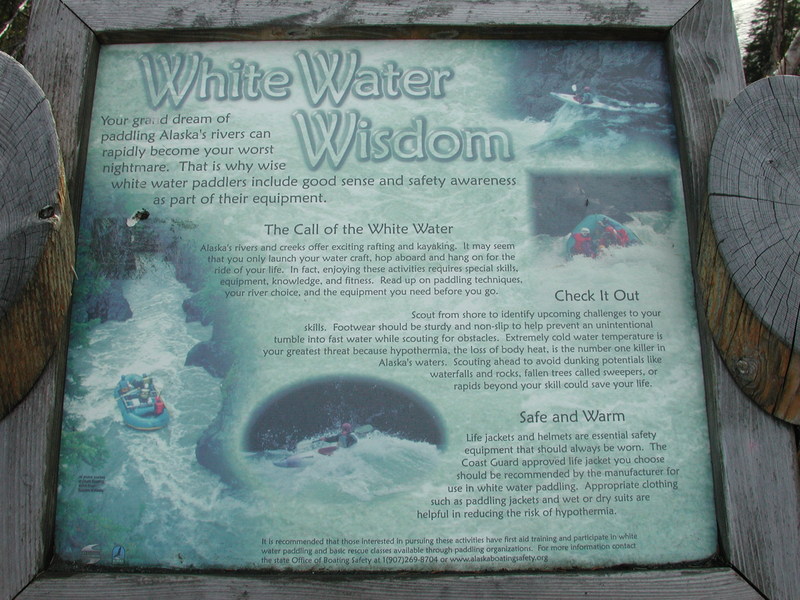
Whitewater safety sign along Sixmile Creek.