| Difficulty | II(IV) |
| Length | 8.9 mi |
| Avg Gradient | n/a |
| Gauge | Norwalk River at South Wilton, Ct |
| Flow Rate as of 45 minutes | 13 cfsbelow recommended |
| Reach Info Last Updated | May 4, 2018 |
River Description
Lat/longitude coords are approximate.
River levels are usually low and unrunnable, so it takes a good amount of rain to make this a worthwhile paddle.
Recommended minimum flow is 200 cfs which makes class II-III, and will still result in some bottom scraping.
Max recommended flow is somewhere around 600-700 cfs. Tight and technical in some sections. Stone bridge can begin to get pretty nasty.
River Features
Put In
Access PointDistance: 0 mi
Stone Bridge rapid
RapidClass: II+Distance: 5.56 mi
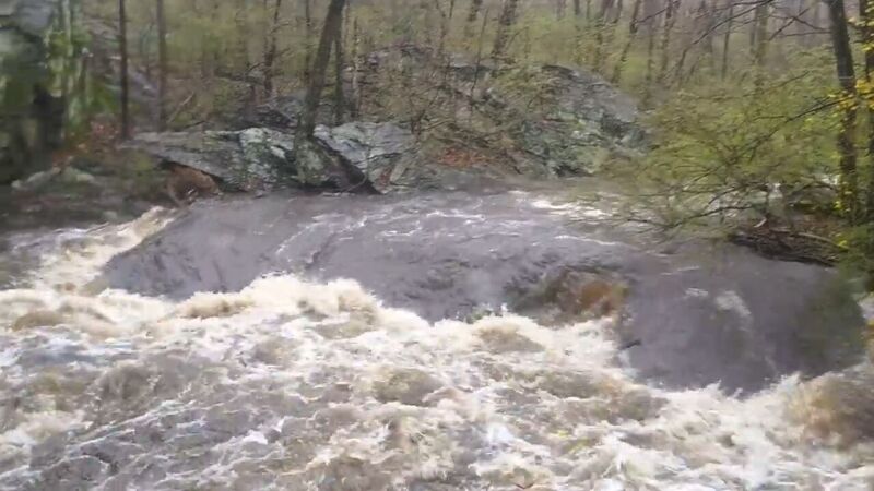
A series of small class II drops culminating in the most constricted section of the river underneath a large stone foot bridge with a narrow archway, that could be considered class III at higher levels. It is below the bridge connecting route 7 and the route 7 connector. River wide strainers above or at these drops are extremely common so consider scounting what you can on foot first. You can do so by stopping at a shell gas station during shuttle and walking a short path over to the bridge to take a look upstream. At higher water this section becomes continuous and a large hole forms just in front of the stone bridge. At the risk of repeating myself, be on the lookout for wood!
Barbell
RapidClass: IIDistance: 6.76 mi
Possibly the steepest single drop on the river since they took out the Flock Dam in 2018, which was just upstream of it. The river winds around a boulder then over a small ledge hole where the dam was, before it splits around a rail bridge tressel. Going right gives you a large eddy to boat scout the drop at lower levels. It is mostly straight forward with some haystacks after, but take caution at low water as there is a knife rock at the bottom of the drop that a curler feeds into. At higher water it becomes a large downstream V with a straight forward line and fairly shallow runout. This is the last drop before the river flows into some ponds along the route 7 connector where the Silvermine river feeds into it.
Take Out
Access PointDistance: 10.7 mi
Trip Reports
Log in to add a reportJK
Low flow run 4/5/24 - Jesse Koproski
Apr 8, 2024
Low water run starting at LA fitness and taking out at the Norwalk River trail near Riverside cemetery in Norwalk. The picture here is of Stone Bridge at higher water than today. Two must portage river wide strainers, one unfortunately just above the stone bridge rapid, although the last two drops in that sequence could still be run. Not much of an issue to get out an avoid at this level. The other is near Merritt 7 buildings before the tunnel. Enough water at this level to get down but I wouldn't go much lower. The expansion of the Norwalk River valley trail has improved access somewhat. Rain this week might give another opportunity for a higher flow run, possibly from park n ride in Wilton near orems diner or from Merwin meadows park (more strainers though). They have removed a low head dam from Merwin meadows as of late 2023 (flock dam by hotel zero was taken out in 2018) but there isn't much left behind in the way of features as they spread out the gradient, unfortunately.
AM
West Rocks Road gauge is at 2.5 feet. 350 CFS RUN - Anatoliy Marashev
Oct 1, 2023
Hidden gem for Southern Fairfield County.