| Difficulty | I-II(IV) |
| Length | 21.8 mi |
| Avg Gradient | n/a |
| Gauge | Weber River at Echo, Ut |
| Flow Rate as of 1 hour | 349 cfsmedium runnable |
| Reach Info Last Updated | May 1, 2025 |
River Description
Taggarts to the Morgan County Fairgrounds is a flatwater extension to Hen-Tag, with a couple concrete rubble diversion structures that should be bank scouted and probably portaged. Tubers often do this scenic 5 mile stretch to finish their run. This could possibly be a good SUP section also.
Note that Fairgrounds down to the Gateway gauge is farmland, probably with fences and without notable rapids. Its roughly 14 miles. There is no run description for that section yet.
River Features
Put In
Access PointDistance: 0 mi
Take Out
Access PointDistance: 5.28 mi
Trip Reports
Log in to add a reportAA
Taggarts to Morgan pickleball - Alec Arditti
Aug 26, 2024
This is in response to Aldo's report below, to fill in the blanks on the 2 upstream diversion dams they couldn't scout.
1st diversion- This diversion structure is boulders racked with large pieces of wood, which appears right after a sharp left bend in the river. River left along the bank had a clear 8 ft wide chute with minimal drop we easily went down without any scouting. It seems like a prime area for wood to rack up in the future, and there is a large eddy/backwater river right at the bend to assess if needed.
2nd diversion- This diversion structure is evenly-spaced large boulders. We pulled to the left bank to scout, clamber up the bank of loose rocks to the road and you can easily see everything or even use to portage. The far left side is easiest, which you can't see until you are almost on top of the dam. Our double IK had a little trouble making the turn to do the drop straight on, because of it's length but we all had fun doing the drop itself (about 3 ft). It may be possible to drop other sections but they seemed to have less water/bigger drops/less safe hydraulics.
The rest of the section was quite pleasant, almost all class 1 with a few wave trains and no people or hwy. The thick riparian buffer was pretty, but also provided many strainers/sweepers, none that couldn't be avoided if you stayed alert and have a paddle. We parked/took out at the Morgan pickleball courts.
We did this section as a continuation of hen-tag in several IK's and a SUP (but would recommend more advanced SUPping skills). This section took us about 2 hours from Taggarts, but the head-wind was brutal the day we went and we took about 20 minutes to scout the 2nd diversion/watch each other. We had a lot of fun doing the diversion structures, but the hydraulics can be dangerous and wood can rack up so stay wary!
AF
Tag-Mor Scouting - Aldo Fernandez
Aug 8, 2024
On August 5th, 2024, a group of four novice/intermediate packrafters attempted to scout the Weber River section between the popular takeout at Taggart Falls and Riverside Park in Morgan, UT. The intent of this scouting mission was to visually confirm clear passage from Taggart Falls into the town of Morgan to extend the popular Hen-Tag route, perhaps the new section could be coined Hen-Mor. Private land made access for scouting difficult if not impossile in some areas.
On satellite imagery the river appears to be mostly very calm class I with at least 5 major river-wide obstacles visible. 3 of these were visually confirmed (feet on the ground) to be man-made check/diversion dams constructed from loosely assembled boulders having drops of about 3-5 ft at 380 cfs that could probably be run by more experienced paddlers in small boats and be reasonably portaged by others. The remaining 2 could not be accessed on foot for visual inspection due to private land issues. This group of paddlers opted not to run this section due to the knowledge of probable obstacles that could not be scouted prior to launch.
The first river-wide obastacle in this section appears on sattelite here and could not be scouted from the ground due to private land access issues: 41°03'06.5'N 111°36'19.9'W
The second river-wide obastacle in this section appears on sattelite here and could not be scouted from the ground due to private land access issues: 41°02'49.0'N 111°36'15.8'W
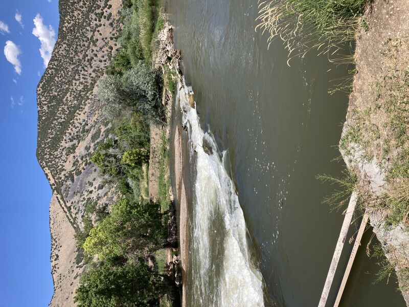
The third river-wide obastacle in this section appears on sattelite here and was visually confirmed as a diverson dam of loose boulder construction (see photo for more details): 41°02'21.5'N 111°39'19.1'W
The fourth river-wide obastacle in this section appears on sattelite here and was visually confirmed as a check dam of loose boulder construction (see photo for more details): 41°02'15.6'N 111°39'40.1'W
The fifth river-wide obastacle in this section appears on sattelite here and was visually confirmed as a check dam of loose boulder construction (see photo for more details): 41°02'27.8'N 111°40'14.6'W
Riverside park offers several opportunities to take-out river right.
BT
Brian Teats
Jun 3, 2011
It should be mentioned, this particularly long section has numerous diversion dam drops rating at least Class III. Portagable, yes, but some fall right behind blind corners, so ears up! (they can be heard before seen in most cases)