Brushy Creek
2. CR 122 (Red Bud Ln) to FM 685 (3.3 miles)
| Difficulty | II-III |
| Length | 3.3 mi |
| Avg Gradient | 9 fpm |
| Gauge | Brushy Ck at Kenney Fort Blvd at Round Rock, Tx |
| Flow Rate as of 1 hour | 108 cfsbelow recommended |
| Reach Info Last Updated | July 8, 2015 |
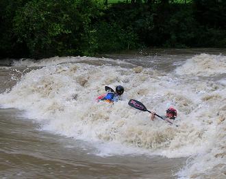
Another play run below Round Rock, which can be combined with the stretch from Veterans Park Dam to CR 122 for a total of 8 miles. Texas Whitewater describes some 'small ledge drops' and 'nice waves.' More specific beta needed.
Distances and gradient measured using GIS tools in 2015.
Cautions:
The ledge below CR 122 and Dave's Rock below 685 change character with very little change in water level. 6 inches is a big change for these features, and they need to be scouted before playing. Both features are great play spots at various levels but can also change quickly.

Parking and access on river right directly under the CR 122 bridge. Stay within the county easement next to the bridge. Do not access the creek using the low-water crossing just downstream of the bridge, as it abuts private property and can become a hazard to navigation at certain flows. A ledge just downstream of the low-water crossing can also become a hazard to navigation.
A low-water crossing and dam structure are potential sieve hazards.
Just upstream of FM 685, there is an old low-water crossing that can be bypassed on river left. Take out on river right under the FM 685 bridge.
Parking is available under the bridge, accessible via a dirt road that follows the state highway easement on the southwest (upstream, river right) side of the bridge from a curb cut along FM 685 about 1/4 mile southwest of the bridge.
No trip reports yet.