Pitman Creek
Route 1247 to Somerset Yacht Club (off Boat Dock Road) (3 miles)

| Difficulty | II-III |
| Length | 3.4 mi |
| Avg Gradient | 15 fpm |
| Reach Info Last Updated | March 2, 2020 |
Pitman Creek offers different experiences at different levels. Its a nice long canoe run at low water, a class II run with some water in it and Class III play creek at high water. Pitman creeks is realtively hazard free and its only hazards are usually washed in wood and one undercut ledge on river right at the gnar only at certian levels. Usually if Pitman is being ran at high water play levels its by Somerset locals or people driven off other regular runs that are too high. There are usually many other whitewater options within an hours drive of Somerset if Pitman is running.
Its classic central Kentucky creeking, a hybrid of sorts. Pittman Creek has the shelf rock ledges as well as the occasional small boulder rapid. Many rapids are typical of Kentucky shallow rocky creeks while others are the same as the rock shelf ledges of Madison County. The first mile or so of the run is basic class II downriver fun. Once you see a pipe on the left from the water treatment plant and the drain affectionately known by local boaters as the Somerset poop chute you begin the fun. Immediately down stream on the other side of the riverwide strainer is the first surfing rapid appropriately named Turd Surfers. A sharp turn in next bend below the cliff wall is a sign the rapids will continue.
The first rapid you come to after the cliff wall is split by an island. The left side is probably the best surfing spot on the river at lower levels while the right side, while currently strained out, is the most creeky with a good 4 foot creek style drop on rocks.
After that a couple of class II rapids brings you into the best playspot out there, named Kiddy Pool it is a great slide hole for 360s and surfs. On down stream is the best stuff where the old Parkers Mill used to be is the best rapid on the river. Tagged 'gnarr' by the locals it is a technical Class III with some manuevering needed, but the danger level is increased by the undercut rock walls at the bottom on th
...Put in near Somerset at a bridge on Route 1247, which is a left-hand turn off southbound 914 Bypass, that connects E 80 and 27 S.
Great for surfing at levels. It is immediately downstream from the poop chute and poop pipe.
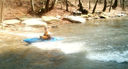
Small surf and 360 wave/hole at low water. Best playspot on the river at highter flows
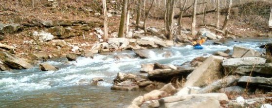
Technical fun at lower water. Big water boogie at higher flows. Watch the undercut shelf on river right at the bottom.
With the lake near summer pool (~720 ft.) take out right about where the creek meets the lake and hump up the ridge trail below Parkers Mill Rapid. At lower lake levels, we paddle a mile of flat water to Somerset Yacht Club off of Boat Dock Road.
Jun 16, 2016
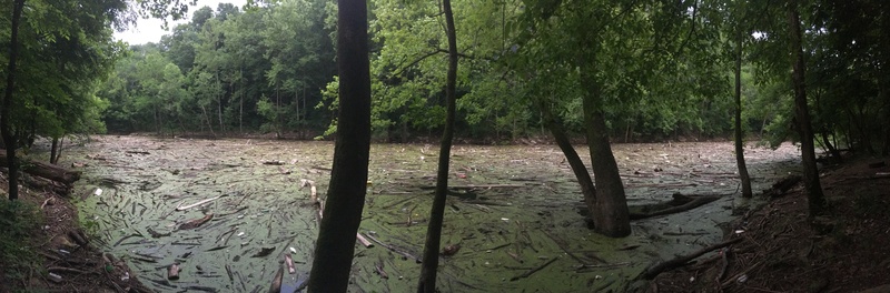
Panaramic of where the trail off Boat Dock Rd meets Pitman Creek as of 6-22-16
Jun 16, 2016
The gate down the hill to the club and ramp is locked for members only. I went to scope out the take out yesterday and it was awful. The trail off boat dock road leads down to big pile of floating trash, logs and algae. It was disgusting. The lake level was right at 720 ft like Duane mentioned. I didn't stray along the shore but it looked like you could see where the creek pooled into this. If you're willing to carry a kayak up the cliff trail then backwooding around this mess would be the easy part. I wouldn't plan on getting out at the ramp though for sure.
Nov 22, 2010
Does anyone know if there are any rapids above the putin for this section?