Annewakee
Anneewakee Road to GA Route 166
| Difficulty | II-III+(IV) |
| Length | 3.7 mi |
| Avg Gradient | 30 fpm |
| Gauge | Sweetwater Creek Near Austell, Ga |
| Flow Rate as of 1 hour | 205 cfsbelow recommended |
| Reach Info Last Updated | November 27, 2014 |
Look for Sweetwater Creek to be runing 800 cfs and rising or locally heavy rain of at least 1.25 inches.
Annewakke will drop back down to nothing in a matter of hours. The sweetwater gauge is used to show if Annewakkee has gotten enough rain to check, but sweetwater holds water for days.
River Description:
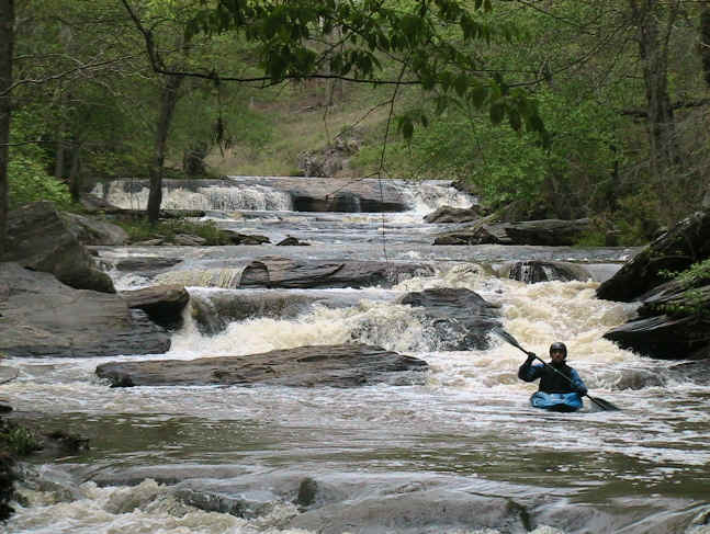
The put-in is on Annewakee Road and there's good parking on the downstream side of the bridge. There is a great but grabby playspot right at the putin. The creek picks up quickly and gets your blood pumping with a few fun class 2's. Then it's flat for a bit... then the horizon line. The first large drop is about 9 feet and reminds me of the Upper Tellico. It's a safe drop if run left of center, look out for the 'Hole of Doom' on the center-right after the main drop. It probably wouldn't kill you but you'd probably swim out. It's easy to miss.
Next is a short class 2-3 section that runs through a power line cut. There are some great waves here! You used to be able to drive (4x4 only!) out the power lines to this spot but thanks to vandals the entrance has been cabled off.
Be VERY careful not to just drop over the next horizon line immediatley after the power lines, you could get REALLY hurt. The next drop is about a 12 footer and really kicks. The river left side is an almost certain pin. The water runs down a slide and hits a jagged rock and forms a kind of mini Oceana with a not-so-forgiving 'Thing'. The left of center line has rocks at the bottom so that's no good. The center line seems the way to go, angling to the right a bit.. Be careful not to get sucked back into the hole at the bottom or you're swimming. The right side could be OK but we didn't run it. The far right side is a plunge into the abyss and we didn't know what was down there so it's still a mystery. The portage is on river right.
After the big drop there is a 1/4 mile of class 3 wa
...
This river wide hole makes a great warm-up spot. The river left side is a cool seam. The river right side is a bigger hole/wave with great play, However... it's quite difficult to make a graceful exit from this side.
This is the first big drop on the creek. Pull over on river left bank to scout this one. The drop is safe all the way across however... There will be an ugly hole awaiting you quickly below the drop if you go off too far to the right. Stick to the left.
Powerline rapid drops over a series of rock shelves creating fun drops and good surfing waves. Eddy out at the bottom on the right before the horizon line. You'll want to scout the next drop.
Right off the center seems to be the way to go here. Too far left is pinning potential. Left of center lands you on a rock shelf. Right of center puts you into the meat. Far right is a possibility. The bulk of the water pours over here and plunges into the abyss... I'd like to see it at lower water before running it. Paddle hard after the drop or the base of the falls will pull you in. After the big drop you still have some manuevering to do. Portage is on river right.
Jun 11, 2011
Just a historical tidbit from a native.
I grew up in Douglas county. Back in the late 80's I helped a friend that did custom upholstery. We did some work for the property owner on the upstream, uphill side of the bridge and delivered all of it over a period of a couple of months. After about the 3rd trip or so, I inquired about the glimpses of water through the trees. He took us back to the lake. It was gorgeous, pristine, and slap full of grown alligators. He put them in the lake 10-15 years before. He harvested them for the hide and the meat. It also had a thriving cottonmouth population that had reached an age and size most snakes don't.
That spillway on the north side comes from that lake(I ca ll it that because it is fed and drained by a creek.). Back in the mid 90's, a gator turned up in that manicured pond just pass the bridge headed toward 92. It was a young adult...8 ft or so. Douglas county sheriff and the local DNR milked that gator for a week because it led all three local newscasts untill they finally hooked the poor thing on a big surf rig.
Thing is, there was no shortage of locals that had the means, skills, and tools to have had that gator on the truck within 24 hrs. There was no shortage of locals that was dying for the chance to catch that gator. I'm sure the sheriff was offered some fat checks for the priviledge. However, catching the gator was a clumsy, amatuer, effort that put the gator under stress way longer than it should. It took hours after the catchee viciously set the hook with multiple, violent upswings of the tree like surf rod trying to turn the gator....by the look on his face caught on camera when the gator turned and ran, he thought he did. He dang near got drug in.
It took hours to land the gator...who was pretty much dead by then.
It's the only time in my life I've been embarrased by the DCSD. Really it was the DNR's guy to blame....he made the call. Being DNR...he should've known the basics behind catching a gator. Short lines tied off to something anchored to land, built to hold a thrashing bull, the gator comes up, eats the bait, then sits peacefully enjoying it's meal. Here's the trick...While the gator is eating, one must sneak up close enough to get a kill shot before the gator see you or hears you which will result in an angry gator on a short rope in shallow water close to you...thrashing so violently getting a kill shot is not an option. The window for a kill shot on a gator...just like a pig, is about the size of a LL baseball on his head.
Anyway, the property owner was elderly back then. I'm sure he's gone. I bet he passed it down to relatives...the property still looks about the same.
Billy
Jul 16, 2010
Ran it a couple of days ago. The big rock on river left at powerslam is gone now. Left line is super fast super fun. The old bridge support that had the red line used as a gauge is gone now too because they are building a new bridge.... I'll work on getting something out there. Sweetwater went up to only 2.25 and we still had good water. Lots of new strainers!!
Nov 28, 2003
Did it today 11/28 We put on at 10. Sweetwater was 4.67 feet and rising. It was definitely low. Doable but too low to be any fun. One thing I have to add is that powerslam is definitely not 12 feet high, it is a 7-8 foot ledge. Oh and i saw the 'thing' it was a large cubic piece of rock that formed a minor sieve and has huge pinning possibilities. It would be a great run with high water.
Jul 2, 2003
I believe the vertical drop above the put-in is the spillway of a residential lake. I've never walked up there, it's all private property on either side above the bridge. I assume you could put in above the lake, paddle across the lake, and run the spillway but I'm not sure. If anyone finds out, let us all know.
May 6, 2003
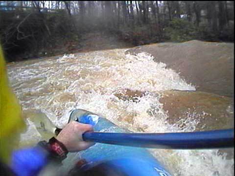
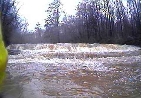
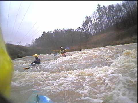
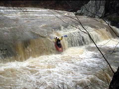
sweetwater peaked at 11.8ft right when these pics were taken
sweetwater peaked at 11.8ft right when these pics were taken
sweetwater peaked at 11.8ft right when these pics were taken
sweetwater peaked at 11.8ft right when these pics were taken
sweetwater peaked at 11.8ft right when these pics were taken
sweetwater peaked at 11.8ft right when these pics were taken.
there was a strainer at this level on far right...probablly not an issue at lower levels
sweetwater peaked at 11.8ft right when these pics were taken
this exploding wave is cause by an undercut/boulder seive that is normally well out of the water. very nasty!
sweetwater peaked at 11.8ft right when these pics were taken
sweetwater peaked at 11.8ft right when these pics were taken
if this ledge looks really scrapy it's probably too low...if it looks side surfable it's good to go...play-able is really good...and when it washses out into a wave it's too high for most of us
sweetwater peaked at 11.8ft right when these pics were taken
notice the water well out of the banks. the water was 1ft below the bottom of the bridge support when I got there and the water just barely out of the banks.
