| Difficulty | II-III+ |
| Length | 2.3 mi |
| Avg Gradient | 40 fpm |
| Gauge | Chestatee River Near Dahlonega, Ga |
| Flow Rate as of 1 hour | 171 cfsbelow recommended |
| Reach Info Last Updated | January 27, 2006 |
A steep and narrow roadside creek similar to Dick's Creek, but without the waterfalls or killer rapids. The rapid flow and nearly constant rapids keep boredom from being a problem. Takes a good bit of water, but less than Dick's, Blood Mountain or Frogtown Creek. Fairly large drainage area so the water stays up for a day or two after the rain ends.
The 1500 cfs minimum is a guess: as far as Streamkeeper has been able to determine, no minimum or maximum has been established before now. Initial evaluation was 01/18/06, the day after a fairly heavy rain, with Chestatee gauge at about 1150 cfs/3.6 feet. That level looked like it would be pretty scrapy, especially in the upper parts of the creek.
The upper section of Boggs Creek (1.8 miles) is within the Chattahoochee National Forest and is scoutable from the road (USFS 443) on the way to the put-in, but some of the most challenging portions (the gorges and Right-N-Left) are not road-scoutable and should be scouted before running. Boat scouting is difficult due to the speed of the flow and the lack of eddies or calm pools, but the banks (especially river right) are usually accessible. The road is never far from the creek, but not easily reachable from the gorges.
Since the creek and the road run through a USFS camping area, there are amenities, including several latrine buildings. The area is undoubtedly crowded during warmer parts of the year and presents a potential hazard unusual for boaters - cross traffic. There are several pedestrian and/or vehicle fords along the run that allow access to campsites on river left, so boaters need to remain alert.
Above the put-in is another one-third mile or so of USFS 443, accessible by fording an unnamed stream or by crossing a wooden pedestrian bridge, built as an Eagle Scout project, beside the road. This upper section of road runs through the upper campground to where Cowrock Creek and another unnamed stream coverge to form Boggs Creek. Streamkeeper h
...Put in either just downstream of the Eagle Scout's pedestrian bridge over the unnamed stream, or shortly downstream where the unnamed stream joins Boggs Creek.
Just after the creek curves left, most of the water runs trough branches along the left bank. Rocks make the center and river right pretty scrapy. Easy portage on river right.
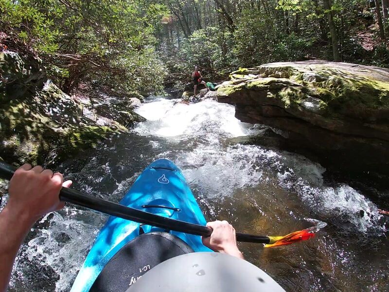
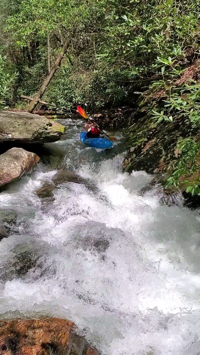
Upper Gorge begins just after Skini Mini. No close examination yet, appears from the road above to be .2 mile of narrow, fast-moving water with nearly several Class II+-III rapids and trees in and above the water (often all the way across). Not scoutable from road.
About 100 yards below Branches Left. A fallen log on river and a tree on river right leave only a narrow channel. Not technically difficult, but requires alertness.
A two-part rapid. First is a narrow, twisting chute largely choked with rocks and logs, followed a decent recovery pool. Second is a steep but less twisting rapid, probably Class II+, leading into Middle Gorges.
Two gorges with a wider, slower section between them. Appears less challenging than Upper Gorge, but only partially scoutable from the road.
A large flat rock on river right forces most of the flow to river left, which also has logs in the water and overhanging branches.
A good-sized rock in the middle stream divides the flow into narrow left and right channels. Left channel appears easier. May be able to go over rock at higher water levels.
Rocks on river right force the flow to river left, through overhanging branches.
A series of hazards in rapid succession over about .2 mile. Just after a road (USFS 443-A) fords the creek is a 150 yard or so stretch with several visible rocks. After the Right curve, the creek is constrained by a boulder on river left leaving two options: a narrow, shallow channel river left or a small drop and quick turn channel to the right.
The area between Right and Left is clogged with rocks, branches and two large trees completely spanning the creek. Depending on how much you want to avoid, short portages are available on either bank. If you want to portage the entire straightaway and Left curve, best option may be the road (but access back to creek is not easy).
Just after Left curve, a large rock on river right pushes the water river left, which also has a lot of overhanging branches.
Another gorge that narrows the creek and speeds the flow. Not scoutable from the road, but appears to be rapids up to Class III+.
A clump of dead trees and branches on river left requires boaters to run river right, where the channel has many overhanging branches.
'Posted - No Fishing' signs hanging from a cable spanning the creek that could be dangerous at high water levels.
Creek passes under Highway 19/129 bridge. Access possible, but difficult due to traffic and lack of parking.
A couple of hundred yards below a red covered bridge are two rapids separated by a hairpin right curve in the creek. The approach to the second and more challenging of the two is blind due to the curve.
Boggs Creek flows into the Chestatee River just a tenth of a mile or so before the takeout. The bridge carrying a driveway over the creek just before the confluence could present a danger at high water levels.
Take-out river left, or continue on down the Chestatee.
Apr 13, 2020
Ran this today April 13th, 2020. After some rain chestatee spiked up to over 3000 cfs. By the time we got on the next day it had dropped a good bit and was still dropping. We drove above the recommended put in and got in another few hundred yards of pretty good class 2 rapids. The run was loaded with trees though. We probably portaged 7 or 8 times due to dead fall. Managed to limbo under a bunch of others. The best rapid is what im going to call 'pinball' 3 or 3+. I'll post pictures of it. The most worth it section was along the road before the confluence with chestatee and after the forrest service area.
Apr 17, 2011
Ran this today with my fiance for an intro to creeking. Gauge reading for this when we were on was 1250 cfs and 3.75 ft. No gauge that I saw at the run. Most of the run was runnable wouldn't get on it much lower. Definitely, a place that can get a little choked with strainers so keep your eyes open. Fun little run.
Jan 19, 2006
Streamkeeper: Rick Bellows, chestateer@yahoo.com. All information is based on observations from land, so please feel free to let me know if you have additions, updates or disagreements. Please also let me know when you plan a run so I can build a database to update and improve the information. Thanks.