Huntington Creek, Left Fork
01. Left Hand Fork
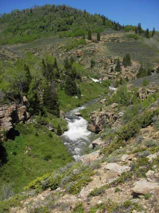
| Difficulty | III-IV+(V) |
| Length | 4.7 mi |
| Avg Gradient | 90 fpm |
| Reach Info Last Updated | July 15, 2017 |
2014-2015 Update: A wildfire has affected a great deal of this drainage, killing thousands of trees. Subsequent avalanches moved hundreds, probably thousands of logs into the river. In June 2014, a group reported extensive portaging. A subsequent high water event (probably on Sept 27, 2014), appears to have consolidated the majority of these logs into 3 enormous logjams, each a couple hundred yards long, approximately one every mile when hiking up from the campground. There is also a new footbridge below the campground, which is very low to the water, and will be a mandatory portage at all levels, unless high water moves it. So there are a minimum of 4 mandatory portages in the last 3.5 miles of this run, a couple of which are around 200 yards long, as well as some other logs that will require heads up boating, microeddy catching, and portaging. The abundance of standing dead trees in the area, and the avalanche paths entering from river right, will undoubtedly change the run on a regular basis. When in doubt, scout.
=======
Pre-2014 run description:
This run is a nice addition to a weekend spent on Cottonwood Creek or Ferron Creek, although LFH has more wood, and therefore is more serious, requiring wood avoidance, micro-eddy catching and portaging, similar to most Uintas runs. It's also possible to catch in the Fall as they release more water from the Upper Huntington reservoirs.
The take out is the day parking area at the upstream end of the Left Hand Fork Camp Ground accessed from UT-31.
To reach the put-in, head west on UT-31 past Electric Lake and Cleveland Reservoirs. Turn South onto FR-014 (Miller Flat Road.) Theres a large parking lot where this road leaves UT-31. There are a couple of options for a put-in. The easiest is to follow FR-014 to Miller Flat reservoir and follow the rough track to the north edge of the Dam. Despite redefining minimum flow levels, this really is pretty convenient. Other options include putting
...No trip reports yet.