Hyalite Creek
1. Grotto Falls to Hyalite Canyon Rd.(The Upper)
| Difficulty | IV-V |
| Length | 0.9 mi |
| Avg Gradient | 250 fpm |
| Reach Info Last Updated | October 30, 2010 |
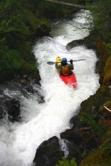
When my friend Andy called last May to see if I was interested in checking out a stretch of Upper Hyalite Creek below Grotto Falls that he had been working on, I was skeptical to say the least. Hell, I had hiked it before and found nothing that made me want to schlep my boat up that trail. Everything I saw was either unrunnable or completely choked out with wood. But after a very short hike from the Grotto Falls parking area, I was shocked to lay eyes upon a very high quality, super steep stretch of sparkling whitewater tumbling down the mountain. The water quality is superb and the entire experience is both intense and intimate.
The put-in is a short bushwhack to the creek starting about 150 yards or so below Grotto Falls. Put on just above Twist and Shout, a beautiful, tight gorgette with three back-to-back pourovers followed by a short low angled slide into a cliff wall. Past the cliff, the creek quickly drops off a fun 5-foot boof before rocketing down the long, crux cascade dubbed Lil Miss Thing?(V). There is a one-boat eddy at the bottom of this drop to stop and catch your breath before peeling out into the remaining 200 yards of fast and furious class IV+. The take-out is a fairly obvious moving eddy on a left bend in the creek.
Take my word: one run will not suffice. It is simply too much fun and dropping this one from top to bottom without stopping is guaranteed to peel back yer lips and leave you grinning from ear to ear. This section of Upper Hyalite flows earlier than the lower run and we found both sections to be running strong near the end of May and early June. Thanks to Andy for all his hard work cleaning this one up.
Head-cam video of this stretch can be found at:
Oct 24, 2025
Can't add to the AW river profile it since its a DNRC gage not USGS, but here is the gauge located just below this run, could help to plan out when its running. Not sure what cfs correlates to it being in, I've never ran it. Would love insight from those who have.
https://gis.dnrc.mt.gov/apps/stage/gage-report/location/791d2c34c893483daf34d34859bd1987
Sep 23, 2009
In order to be sweet, this needs to be high! Aim for peak run off in the area, perhaps just a bit sooner. Also, New wood is moving constantly. Check out the whole run before dropping in.
Dave
Jan 1, 1900
This run is non-stop 1/4 mile of pure adrenaline.