| Difficulty | I(IV) |
| Length | 6 mi |
| Avg Gradient | 17 fpm |
| Gauge | East Fork Whitewater River at Abington, in |
| Flow Rate as of 34 minutes | 115 cfsbelow recommended |
| Reach Info Last Updated | August 5, 2017 |
River Description
Fair gradient should make for a pleasant swiftwater float.
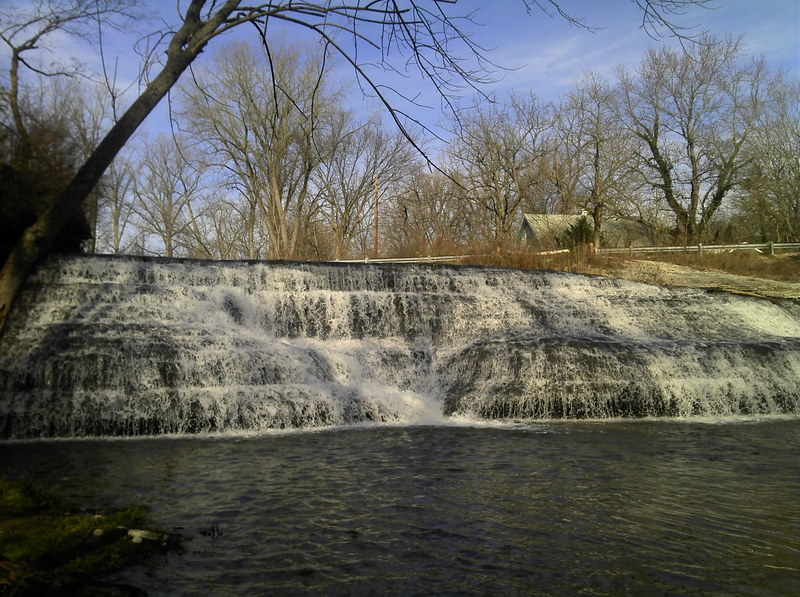
While in the area, check out nearby Thistlewaite Falls, which is not a natural falls, but was created by the damming of the river, causing it (at overflow) to pour across a picturesque scalloped-rock falls.
The various weirs and dams in this area should all be inspected (at each different water level) to carefully assess the character of the boil line. Some may create very interesting and fun play at the right levels (if there is not a river-wide rolling boil-line), or extreme danger (if there is a deep rolling boil). If you are not experienced enough to fully understand the difference, PORTAGE, taking out well upstream, and putting in well downstream from low-head dams to avoid their deadly undertow.
Some photos and description of sites in this area is available at: Gorge Trail.
River Features
Middle Fork Dam
HazardWaterfall / Large DropPlayspotDistance: -4.1 mi

Another site potentially worth checking out in this area would be the Middle Fork Dam. Just downstream of the spillway, the river trips across a couple of interesting looking ledges.
Drainage area at this dam is 47.66 square miles, so it will have very little water much of the year (as currently showing on aerial views), but should get enough flow to be interesting after good rainfall.
Distance is listed from the put-in of the run on the E.Fk., and is listed as negative to indicate this is NOT ON the run of the listed section.
Thistlewaite Falls
OtherClass: IVDistance: -3.8 mi
NOTE: This feature is NOT on the listed run, but is nearby, and worth a look when in the area. A very steep sliding drop into a generally very shallow pool.
(NOTE: Distance listed is from our listed put-in to this falls, and is shown as negative to indicate this is NOT ON this run, but is on a tributary, the West Fork of the East Fork Whitewater River, which has ~20 sq.mi. drainage at the falls.
Put In
Access PointDistance: 0 mi
Drainage: ~45 sq.mi.
OtherDistance: 0 mi
Drainage area at our indicated put-in is ~45.3 sq.mi. (as calculated via USGS StreamStats Beta software).
Dam?
HazardDistance: 0.3 mi
Aerial view appears to show a riverwide horizon line at this point, most likely a low-head dam. Approach with caution and get out to scout (and most likely portage at most, if not all, water levels). The concern is not about the height of the dam, but the boil-line below it! Pay particular attention to how far downstream from the dam the water boils back and recirculates. Do not even think about running a dam unless you have looked at it very carefully first, and you have someone on shore, with a throw rope, and you all have knowledge and practice with its proper use!
Dam?
HazardDistance: 2.25 mi
Immediately prior to N.17th Street, there appears (on aerial views) to be a uniform horizon line -- another likely dam. As on the prior description, scout and pay very close attention to the strength, width, and distance downstream the boil-line extends.
Confluence: Middle Fork
OtherDistance: 2.81 mi
Between N.12th Street (AKA Middleboro Pike) and Hwy.27 (Chester Boulevard), from river-right, the Middle Fork of the Whitewater River enters. This branch is of very nearly equal size, so flow will now be nearly double that at the put-in.
Dam?
HazardDistance: 3.75 mi
As you approach Richmond Avenue, be ready to scout once again, as there appears (on aerial views) to be another dam or 'ford' in the river. This one appears to have a sloping spillway across the center, with higher shoulders toward either shore. This configuration may allow for some whitewater play (at some flows), but the same cautions as before still exist -- ALWAYS SCOUT THIS BEFORE RUNNING IT! Check for height and distance downstream any boil-line might extend.
Take Out
Access PointDistance: 5.8 mi
Former USGS Gauge: 121 sq.mi.
OtherDistance: 5.8 mi
A USGS gauge at our listed take-out (which had existed until 1978) lists drainage area of 121 square miles.