Big Creek
Roswell (Vickery Creek)
| Difficulty | I-III(V+) |
| Length | 2.5 mi |
| Avg Gradient | n/a |
| Gauge | Big Creek Below Hog Wallow Creek at Roswell, Ga |
| Flow Rate as of 45 minutes | 62 cfsbelow recommended |
| Reach Info Last Updated | June 16, 2022 |
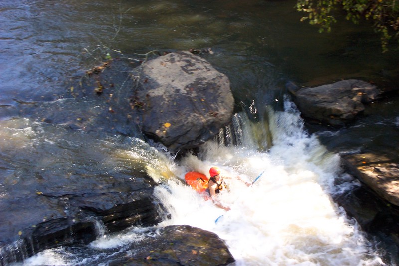
This section is highlighted by the third of mile of Class 2 whitewater below dam and the gorge that the river cuts through on its final descent to the Chattahoochee River. In the not too distant past Big Creek received direct sewer overflow. The water quality has improved greatly, as can be quickly seen from the improved turbidity (down to 2-3 feet), the presence of insects, mollusks, and fish in the river. The creek is narrow above the dam, no more than 25-30 feet, and is subject to river wide strainers. Below the dam Big Creek widens to more than 50 feet.
For a map of this creek check out the National Park Service website
Vickery Creek
or the 2002 updated map.
From Grimes Bridge Big Creek is impounded for nearly half a mile by a low-head dam that requires a mandatory portage. Just below the dam is the mouth of Hog Wallow Creek, entering from the right (mile 0.5). From here whitewater returns with a few Class 1-2 rapids. Soon the creek is crossed by an elevated sewer line that requires a portage. Just below the portage, on the right, is the western trailhead (mile 0.7) for the Oxbo TrailÂparalleling Big Creek from Hog Wallow Creek downstream. There is a parking area, which makes for an alternative put-in. From the parking area the creek stills as it bends to the left. In little more than a quarter mile from the Oxbo parking area the creek is crossed by another elevated sewer line (mile 1.2)Âalso requiring a portage. From here it is another quarter mile, as the creek bends to the right, to the still waters above the dam (mile 1.5)
Given the two impoundments and the necessity of making three portages, this section is better enjoyed on foot along the trails that parallel the Creek, either CNRA trail on river left from Grimes Bridge to Hog Hollow Creek, and below
...A potentially deadly low head dam exists at the start of the run.
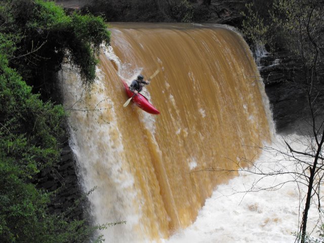
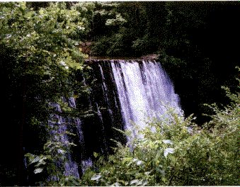
As noted by Brad Roberts, Vickery Creek Dam is a 30 foot back breaking drop onto solid rock. It has been run, but the results are mixed; with at least one broken back. The dam was originally constructed in 1836 to provide water for the Roswell Manufacturing CompanyÂone of the largest textile mills in the southeast. Destroyed during the Civil War it was rebuilt and expanded. The mill that stands today, near the covered bridge, was constructed in 1882 and continued operation until 1975.
Ledge below the newly constructed covered bridge.
Mar 19, 2012
This stretch of water is greatly affected by storm runoff, so I don't know that I'd really want to try it except immediately after some rainfall. When we ran it, the creek was around 4 ft and 400 cfs, and looked very impressive compared to its normal, tranquil self. Park at the old mill and carry your boat upstream towards the dam. Pick a spot and put in and you will hit the fun stuff almost immediately. We were surprised by how fast we were moving and it is easy to get 'behind' the boat if you don't stay on top of things. The water will be very muddy and turbulent, but it seems to be mostly silt and not sewer; my friend swallowed some water but didn't get sick. Since it is post-storm runoff, there were also large branches and small logs floating around us. Once you get a little below the covered bridge, most of the excitement is over and all too soon pulling out on the left at the national park parking area just before Riverside Drive. At this level, we didn't have any problem going under the sewer pipes, but it doesn't hurt to walk downstream (path on the left side of the creek) and check. We did this one afternoon after work and could have run the river a couple more times before dark; we were in an out in less than an hour. One nice thing is that you are in the middle of a major metro area, but you are surrounded by the terrain which makes it seem more remote. Lots of fun for some afternoon giggles and the novelty factor.
Sep 26, 2009
jim verner
jimvern@bigblackdick.com
i just boated this creek on sep. 20, 2009, right when the storm was in atlanta. only because sope creek was to to high. you could hardly get under the bridge of sope creek. 3 cops were talking about arresting me. i simply said there are no signs saying i cant do these. well they let me go. this creek is short but so much fun when its in flowed stage. i had my creek boat, you can park at the Roswell mill and its a park and play creek because the run with rapids is short. when it flouds there are two places to surf. 1) right before the bridge but i would look at it first. 2) after the bridge about 100 yards. this one is deep enough to throw loops.
Mar 20, 2008
We ran this last weekend from the park just below Grimes Bridge down to the Hootch. The flow was at 480 and made for a very fun SHORT run. Great for a quick afternoon run, (we only live about 20 min's from the area). Next time we will put in at the old mill just above the covered bridge. This will eliminate 2 of the portages and still let us enjoy the best of the rapids.
Sep 5, 2003
From Boatertalk:
Re: Vickery Creek/Big Creek - Georgia by Gorman Oct 04 2002, 0:03 GMT New
Date: Oct 04 2002, 18:10 GMT
From: river1313
I hiked and paddled up from the Riverside Dr park to the base of the dam and paddle down from there. Good class II-III drops for about 150 yrds at medium water levels then flat water. I've looked at it from Roswell Mill at really high water and it was big and moving fast. There are a couple overhead pipes that I'd worry about at this level. A lot of work for not a lot of whitewater...I'd say only worth if you live very close by. I haven't been on it upstream of the old mill dam along Oxbo Rd...I noticed driving along it the other day there is a low head dam with maybe some class II below it.
One very important thing to note...THE WATER QUALITY IS NASTY!! There were signs in it saying no wading and warning of the high fecal coliform counts. I'd say this makes the Chattahoochee look pristine. It's the reason I only like to paddle the Hooche upstream from Big Creek.
-chad-