Chattahoochee
3.14 - Upper Hooch - GA Route 115 to Duncan Bridge Road(Upper Hooch)
| Difficulty | II-III |
| Length | 4.1 mi |
| Avg Gradient | 25 fpm |
| Gauge | Chattahoochee River Near Leaf, Ga |
| Flow Rate as of 1 hour | 2.47 ftrunnable |
| Reach Info Last Updated | February 18, 2023 |
RIVER DESCRIPTION
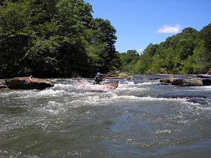
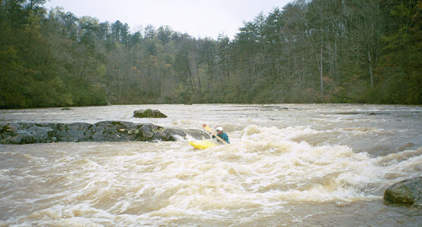
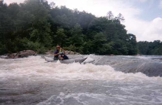
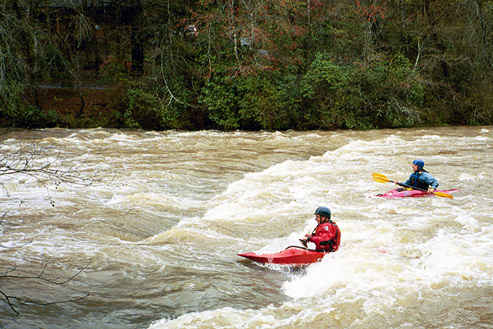
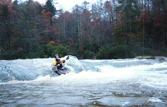
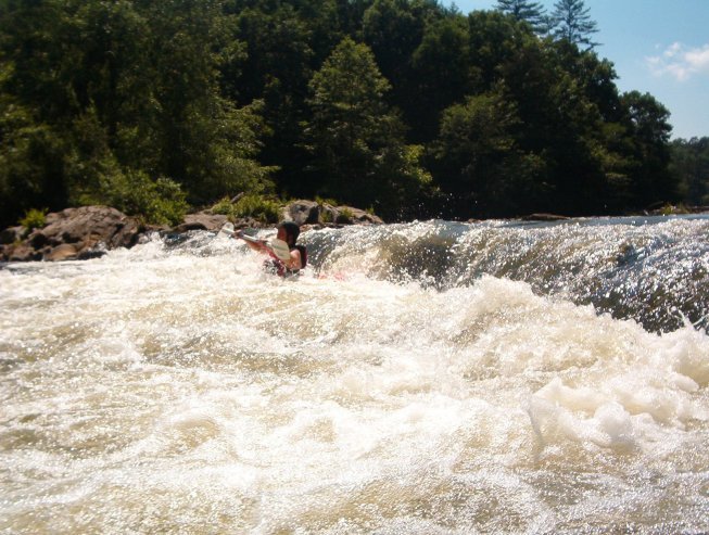
The Upper Hooch (not section 3 - thats over on the Chattooga) is a classic beginner canoeing and kayaking stream. Its relatively short, has an easy shuttle, decent scenery and fun rapids. It can be run at just about all levels from ridiculously scrapy to screaming high flood stage, depending on the boaters skills of course. At low flows its a class two stream. Around 3-4 feet on the Leaf Gage its easy Class III. Above that its class 3/4 with some huge holes.
Once upon a time during the winter of '96-97 a group of us ran the Upper Hooch at 13 feet (about 14,500 cfs) on the Cornelia Gage. Lots of moving strainers. Two massive holes in First Island rapid that were of equal size to the top holes in Insignificant on the Gauley. The rock outcrop on the right at second ledge was a giant pourover. Third ledge was washed out. We ran it twice before the Hall and White County rescue squads closed down the river. Probably a good thing--three other groups put on and hiked/swam off. Lots of canoes wrapped around trees that day.
Flow Info: (NOTE - we have begun using the Leaf Gage rather than the Cornelia gage on this page as of 2/15/15 because it better reflects the flow experinced on this reach)
For the Leaf Gage, consider the following advice:
4 = High water, additional skill required (III/IV), not good for beginners.
Parking Info: The put-in and take-out is Georgia State Park land, and requires either a daily pass ($5) or an annual pass.
Wildwood Outfitters has an outpost at the take-out and will shuttle you and your boat to the put-in for $7. The outpost is usually
...
Multiple routes on both sides of the island. Big holes develop on the right side of the island at high water. At lower flows most people run the narrow channel on the left of the island.
Rock on river right above the Lunch Beach. Good surf wave with a huge eddy on the bottom right.
At flows above 2500 cfs or over about 4 feet a dangerous low head dam type hole forms on the right side of this rapid. This one is easy to see coming due to the long pool above it and the large rock outcrop on river right. Run left or right at most water levels.
Fun, shallow side surfing hole. At flows around 3 feet the center of the hole can hold swimmers for a dangerously long time. Easy to skirt the center on either side.
Another long wide shoal rapid. At higher flows there is great surfing everywhere in this one!
A long riverwide shoal, with a sandy beach at the bottom on river left. Lots of fun small waves and holes thru the shoals.
long fun shoal rapids with some good surfing opportunities.
Just downstream of the takeout, below the bridge, is one last ledge. There are a series of holes on the right, and a wave on the left. At low flows there is an island in the middle. Play your brains out, then paddle back up the 100 yards to the take-out.
Feb 11, 2022
Fairly new to paddling and I find this section pretty fun. Ran as low as 2ft, high as 2.8ft. Both levels were decent. No strainers observed on my last outing.
May 31, 2020
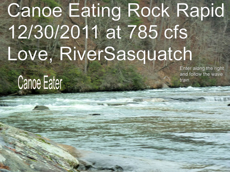
Ran from 255 to Duncan Bridge 5-30-2020 in a tandem canoe with Ted Harrigan, at 2.5 level. The way the water channels at this level, made maneuvering difficult for a tandem canoe and created a lot of force in the channels. A little more water would have made it easier and safer, for a tandem canoe. Said rock did eat our canoe.
Aug 12, 2019
For more recent information about this section of the 'Upper Hooch' go to this Facebook page.
https://www.facebook.com/groups/1635943616667976/
Aug 16, 2016
Note that the flow levels on the Main page and Flow Info page are very WRONG and misleading. The gauge reference has been switched from the Cornelia to the Leaf gauge, but all the reference / guidance info is still based on the Cornelia readings. The Leaf gauge is a better indicator of what is happening on the run, but the info on these pages will mislead people to run this at bone-dry levels. Also, in researching the USGS historical data for the two gauges it appears the Leaf gauge DOES NOT show high water events correctly. It appears to clip/limit the level reading for everything above 2100cfs (a medium level). This will mislead people into running the river at very high & dangerous levels if only the Leaf gauge is used. Here is a better reference table for the Leaf Guage:
< 2.5 = Very Low;
2.5 - 3.5 = Low but runnable;
3.5 - 4.7 = Good for a wide variety of paddlers (II-II+), surfing begins to get good.;
LEAF GAUGE STOPS WORKING ABOVE THIS POINT. LEVELS BELOW ARE FOR THE CORNELIA GAUGE
2.8 - 4 = Class III whitewater, good surfing, good flow range;
> 4 = High water, additional skill required (III/IV), not good for beginners. ;
Here is the full correlation between the two gauges. The Leaf clipping at 2100cfs occurred at the last high water event on Feb 24 2016. It should be assumed it will mislead on the next high water in the future - check the Cornelia gauge to be safe.
Upper Chattahoochee Gauge Correlation:
Cornelia 0.4ft, Leaf 1.7ft, 200 cfs;
Cornelia 0.6ft, Leaf 2.0ft, 300 cfs;
Cornelia 1.4ft, Leaf 2.8ft, 700 cfs;
Cornelia 2.2ft, Leaf 4.0ft, 1500 cfs;
Cornelia 2.8ft , Leaf 4.7ft, 2100 cfs;
Cornelia 3.0ft , Leaf 4.7ft, 2300 cfs;
Cornelia 3.7ft , Leaf 4.7ft, 3000 cfs;
Cornelia 4.6ft , Leaf 4.7ft, 4000 cfs;
Cornelia 5.5ft , Leaf 4.7ft, 5000 cfs;
Cornelia 6.3ft , Leaf 4.7ft, 6000 cfs;
Cornelia 4.75ft , Leaf 4.7ft, 6580 cfs;
Jun 20, 2014
You need flows up above 350+ to even think about running this section. Ran it on 6-7-14 and it was a chore with flows hovering around 250. Use the gauge reading at Leaf because the gauge downstream includes the Soque River added flow. Very scrapy on 6-7-14. Ran it a few weeks previous at around 400 and it was fun. The ratings are a bit high, but Hawkeyes below mentions running it at 1800..... I checked his dates and his run was at flows around 800-900. While it would be a blast at those flows, trust me, at 1800 this is a tough run for anyone but a very experienced boater. We often run the section below this in conjunction with this run as we are local and run one of the two sections two or three weekends per month from late April thru early October.
Mar 18, 2014
Ran on 18 MAR 2014 at like 1800 CFS. Fun little beginner run. I'd say it's easier than the Cartecay at 2.5' at this level. It's DEFINITELY not a class III run. Buck Shoals is is no way a III+. Tablesaw and Broken nose on the Ocoee are III+'s. Baby Falls and the upper ledges on Telli are III-III+. Buck shoals at 1800 is a long class II. Maybe a II plus. I feel like calling Buck Shoals a III plus and Horseshoe a III scares beginners off of this run, and probably gives people that have run this the false idea that they can just go up to the Tellico or Ocoee and be fine... Maybe these rapids were class III like 30 years ago but they aren't anywhere close to the modern standard of class III.
TL;DR: At 1800 CFS nothing on this run is above II+.
Mar 18, 2014
Thanks for the feedback on the ratings of the upper hooch. Since I have not made this run I rely on feed back from people to properly describe & rate this section. If you ever have an interest in becoming a stream keeper and correcting out of date info on rivers you paddle please contact me. David. Strive2@ymail.com