Dog
GA Route 5 to Dog River Reservoir
| Difficulty | III+ |
| Length | 3.9 mi |
| Avg Gradient | n/a |
| Gauge | Dog River at Ga 5, Near Fairplay, Ga |
| Flow Rate as of 44 minutes | 19 cfsbelow recommended |
| Reach Info Last Updated | March 1, 2006 |
Put-in on Georgia Hwy 5, or one mile upstream at Banks Mill Rd.
Take-out is the Dog River Reservoir at Hwy 166. The takeout is open from March thru November.
The Dog River is a good piece of whitewater if you are a Douglasville Resident.
For the rest of us its an exercise in beauracracy. Until 1992 the take-out was at Hwy 166. Then Douglas County built the reservoir, not seen on the topozone map. For a time you could not use the takeout/boat ramp on the reservior unless you were a douglas county resident. The current status is somewhat in limbo.
Now for more bad news:
Evidently Douglas county needs more water. So the water level on the reservior is being raised ten feet. This should occur sometime in 2006, shortly after the new bridge on Hwy 166 is completed.
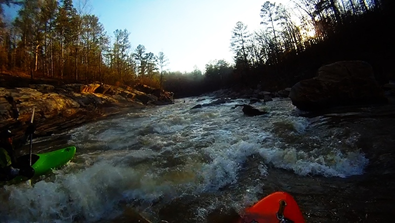
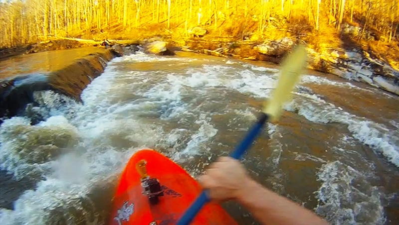
The river itself is a class 3 run over bedrock ledges. At higher flows nearing floodstage it might bump up to class 4.
For more info on the rules and regulations:
Douglas County Water and Sewer Authority.
Dec 6, 2014
DogRiver - Please email me with your contact information @ rekayak@gmail.com as I would like to calmly discuss as I am afraid that you may be mistaking what some other groups are doing on your property as no one that I am paddling with is doing that. I would like to get to the bottom of this and like you... discover who is doing that as I have never been on the river with anyone that would do such things. I don't even know of anyone that paddles with a gun or why they would so I am leaning toward this not being paddlers that you are addressing in this forum. I don't even know of anyone on this forum that would try to camp out on the Dog River as it's such a short run. I to am a property owner on a river in the state of Georgia and fully understand. Thanks and I will get the word out about the issue - and if it is someone in our paddling circles we will address this with them. Looking forward to help address this situation with you. Chuck Kirk
Nov 26, 2014
This is the first rapid after the beach. This rapid changes its name to Little Woodall around 1000cfs. At flows below 600, this is a very quick right to left channel with two submerged rocks in the middle of the flow. The current flushes you out of the center. There is a cheat that follows a straight channel down the extreme river right that will lead you to Painted Dwayne.
Nov 26, 2014
The posted signs start at the Big Island Rapid and continue into the flat water a bit and up onto the large hill on river left. The first one is located on river left in the middle of the rapid where it is too late for a kayaker to read and portage. None of the signs I saw had any information on them. The signs were plastered all over the once-beautiful hill above the river.
If DogRiver guy would list his phone number or address, we could all ask him for permission to float above his property, but until then, we can all just stay in our boats until we pass DogRiver's lair.
Nov 24, 2014
I own river property in the state of Georgia on a navigable river and you cannot stop people from floating by. Even if you own both sides of the river, so I am not sure what DogRiver guy here is talking about. Just because the owners don't like it they can only own the land under the water not the water itself and Dog river is considered navigable. State law trumped Douglas County in the 1990's. I have 'heard' reports of people still having issues - none confirmed... I have not personally had any issues with Douglas County since then other than trying to charge for parking at the reservoir nor have I had any issues with any of the land owners there. I'd be really interested in any current lawsuits if anyone can provide information not from the case in the 90's.
May 15, 2014
There's basically no information/photos on this run, so, here's a little more: We ran this today around 300 cfs on the correct gauge that you can find at http://waterwatch.usgs.gov/?m=real&r=ga&w=map. The correct guage is titled Dog River near Fairplay, Georgia. The river includes lots of class II stuff and a couple of class III's at this level.
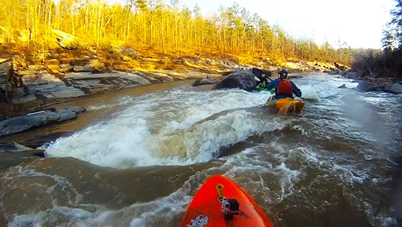
This was my first time down, and I was really impressed by the river. The rapids are fairly technical. There are a few longer set of rapids with lots of eddies, ledges, and some waves trains. It's not all drop and pool like many of the II-III rivers in GA.
The river's a good time, when it's running. There is also about a mile of lake paddling at the end. Check out the video I posted on youtube (that wouldn't fit on this site) titled 'Bradley on the Dog River near Fairplay, Georgia' and a newer video from a fella I know https://www.youtube.com/watch?v=rqzbfHNQ0WE. His video was shot at 265cfs on the waterwatch gauge.
Update: There are now many videos of the Dog at low water (200-400 cfs) thanks to Josh Ames aka riversasquatch. The highest I've had the pleasure to run at has been a little over 500 cfs. The river is more pushy with bigger holes and waves, but nothing drastically different. Others I know have ran it up to 800 cfs (and once at 3600 cfs, which won't happend again). They reported much larger waves, holes, and push than at lower levels. The III+ rating is probably justified at these levels.
Feb 22, 2013
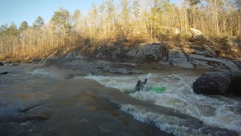
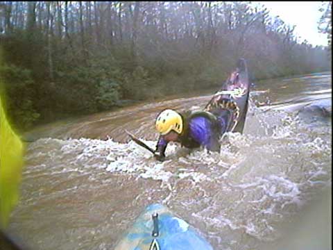
The Legend Dave Collins flirting with Painted Dwayne 'The Rock'. The easier line is to run to the left of Dwayne, but Dave plays by his own rules.
Jun 11, 2011
I'm a native that grew up swimming and floating on Dog river, annewakee creek, sweetwater creek. I'm from Winston near the powerlines that cross I-20 west of post road exit. There's a tunnel under I-20 and the powerlines to allow a small but crystal clean creek to cross. A smaller creek that started from a spring behind the house I grew up in joined the tunnel creek. Together they go south east toward the backside of the Clinton estate where they turn into a large, natural, shallow swamp like wetland. Then the waters drain from the wetland and soon drain into dog river.
Before there was a Douglas county Water AUTHORITY....every creek in the county was accessible. The large, older, reservoir called Bear creek was open to the public to fish. Hard to get to, but held the biggest bluegill and shellcracker I've caught. It was loaded in big bass too, but it was big enough to require a boat to reach them. The concrete spillway on the dam end was loaded in big bluegill. There was a 2 story pump house on the dam that some would jump off of. Nobody ever died.
That spillway flows into Annewakee creek which crosses 166 then drains into the hooch. You could hike from the 166 bridge in or drive in the headwater end if you had 4 wheel drive and some clearance.Just west of this spot off a dirt road was the trail down to the old 'beach' part of dog river. Some rapids...sand beach...and a deep fishing hole. The reservoir(Built by taxpayer funds), Annewakee creek, dog river, and the tract of woods around it make up some of the most beautiful landscape in the county.
Thing is....the landowners surrounding that whole area were composed of Old money Douglas county power brokers....Judges, DA, Dr's, etc and they were all from the original group of families that settled the county. This same group also owned the Douglas county hunt club property a few miles west on 166, the same group that permitted a wealthy, female, property owner to get the permits so she could rescue unwanted big cats from zoos. Lions, Tigers, pumas, panthers numbering in the hundreds. I saw them with my own eyes. She spent millions for the fencing and the insurance etc...did everything the county asked. Then, after the downturn in the deer population started in the late 90's, and the prestigious DC hunt club had several slack harvests in a row, they decided the woman and her cats were to blame. She was forced to shutdown for some BS violation, but to the chagrin of hunt club, she had the money to stall in court by appeal long enough to turn loose a few here and there, about 15-20 yearlings that had been born in her care that she raised to like squirrel, two breeder adult females, and one adult male...all American cougars...a species that use to roam Douglas county woods before the white man came.
Anyway, when the idea of building dog river reservoir first came up, and citizens heard the initial proposal of fee structure...folks went off. They were higher than they are now to begin with. Folks went off because like me, they had been around long enough to know who benefited from owning the land around the area, they knew their water bills and tax bills financed the reservoir, they knew that several old money landowners made a killing selling property that was worth little(!,000 acre) but was bought for much more (10,000 acre) because they acted like they didn't want to sell. The flooded reservoir made the land they didn't sell but bordered the reservoir worth much more. And the county would save millions from the water the reservoir provided.
All this funded by tax payer money. If they hadn't gotten so greedy from the get go with the proposed fees, which they lowered but are still high, nobody would've cared. When angry residents let the county know they wouldn;t spend one dime at the new reservoir, they quietly shut off access to the older reservoir at bear creek. For years I fished there getting checked once or twice a year by DNR, It was a real muddy drive down there....Then one year, down on the spillway end, I saw what looked like a DNR truck but as it drew closer I realized it said 'Water Authority Law Enforcement'. Had ANY part of my mind knew I was no longer legal there when I first saw the truck on the headwater end, I had a thirty minute head start to make the 10 minute run into the woods following Annewakee creek out to 166. They never would've stood a chance of catching me, even if they started out right behind me. Nope...I stood right there and two armed 'WATER POLICE' came out of their truck and informed me I was tresspassing, that I was going to jail, and my fishing gear would be confiscated. They thought they had me when he called DCSD over the radio asking for a deputy to meet them at the road because their authority ends there. The dispatcher said gimme a min to find a deputy. In that wait I told them that they had no power to arrest me physically untill the deputy got there. I told them that If I so choose, I could break for the woods and would be on 166 before they even got to kings hwy on the other end. And I also told them that I wanted to talk to the sheriff himself over the radio or I would not go along peacefully to meet the deputy at the road and any physical contact on their part would expose the county to a nice lawsuit and prolly cost them their jobs. I also expressed my disdain for the sneaky way the county suddenly changed the rules without saying anything all so the big wigs in the county could have a taxpayer funded private hunting and fishing preserve. I was let go with a summons to appear in court.
I went before Judge James(Who owned property bordering bear creek) and David Mcdade. I got a lecture about trespassing laws and was fined $50.
That's why things are like they are now. It's a crime that the citizens of this county are held back from enjoying the beautiful, wild, creeks and rivers that we grew up enjoying and were stopped from using because of dog river reservoir. Actually, had someone dropped a dime to Dale Russel..this would blowed slap up.Since the days of Earl Lee and his magical escape from some sure fire ugly charges the atlanta media has been itching to get dirt on old Douglas county power broker families.
Mar 10, 2011
I took a trip down it yesterday. It was at a 1000cfs which made it much more interesting then the lower levels I've done it at. I would go as far to say that some of it had me thinking class 4 and one hole that was worse than the hole on Woodall Shoals on the Chattooga. The hole is the next rapid past the little S turn(which at this level it wasn't an S turn anymore.) by the beach/campfire area. A couple feet down stream right in line with the hole is a big undercut rock. You can portage the hole on the left or right or run down river right side of it and take your chances with a couple sharp rocks. At 400cfs and lower you don't need to scout anything, unless you are newer to kayaking or just not that good. This is a great place to kayak if you want to see the damage done by the Nov. 09 floods.
There is a put in at the hwy 5 bridge its next to the bridge off the side of the road. If you don't want to pay at the take out, look at a road map, you'll figure something out. If your planning on making a trip down it and want someone else to go with you my email is david.e.collins81@ gmail.com, I'm local.