Dog
GA Route 5 to Dog River Reservoir
November 2, 2010
| Reporter |
Alright... so I took my buddy who had never paddled a kayak before to the Dog River Reservoir today. Because there is hardly any information on this site or the internet (especially since the flood in '09), I will write as much as possible.
First, we pulled into the reservoir parking lot. We had no plans of going down the actual river due to a lack of information on the rapids or dangers, so we paid $1 admission/person + $5 for each boat for access to the reservoir. I am not sure how the payments would work if you were merely pulling out at the reservoir. The park ranger was talking to us about the Dog River and how it is bullcrap that it is good for kayaking. I think part of his rant on the inadequacies of the actual river was to keep kayakers away.
We put the kayaks in at the boat launch at the bottom of the hill and headed north toward the mouth of the river which was about a .5 miles up-current so it was a little tough.
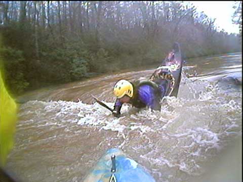
We made it up to the mouth and got out of our boats because there just wasn't enough water. The water level according to the gauge on this website read 7.3 cfs. However, there did seem to be some definite potential in the flow of the water around the rocks that this could be a pretty fun river at about 200- 500 cfs... I am not sure of the conversion into feet, but if there was about a foot of extra water, this would have been impossible to pass up dragging our boats on the rocks to get to a few of the chutes and drops that we walked to today. This last section of rapids is named Zippy's Bender and with a 500 cfs I would have to say it would probably be class II+.
However, with a lot more water, it would have been impossible to see the amount of trees and roots that had been deposited during the flood of '09, so it would be best to stay in your boat. Almost every rock looked to be undercut or atleast pointing upstream... I am no expert, but I definitely would be a little insecure while running this with a lot of water.
We walked about a quarter-mile upstream and found a few more drops of 1-3 feet that had a surprising amount of water flowing through for such low reading in cfs. In this section of the river there is a large house up on the hill overlooking the river on the right. Seeing this house will represent the last section of rapids before the river empties into the reservoir. There will then be another smaller house closer to the river on the right and during this section, you will want to stay left due to the undercut rocks that line the right hand side of the rapid. I am posting a couple pictures, so please take a look and if anyone is able to read rock structures, please let us know if there truly is potential to this section.
I look forward to the next rainfall because I will definitely be trying it out. The ranger told me that anybody that plans on parking at the reservoir has to be there by 12:00 or you will never make it back prior to them locking the gates at 6:00 or 7:00. He also said that the last day that the reservoir will be closed on November 20th and open back up in March.
We drove past the HWY 5 putin and there looked to be a lot of water in that section but nowhere to park.