Rottenwood Creek
Windy Hill Rd to Chattahoochee River
| Difficulty | III-IV |
| Length | 2.9 mi |
| Avg Gradient | 50 fpm |
| Gauge | Rottenwood Cr at Interstate N Pkwy, Nr Smyrna, Ga |
| Flow Rate as of 6 hours | 11 cfsbelow recommended |
| Reach Info Last Updated | January 26, 2024 |
Gauge Description:
Visual from one of many bridge overpasses. (Delk, Terrill Mill, Windy Hill, Windy Ridge, Interstate North, I-285, and Akers Mill)
Rottenwood only runs after heavy rains, and runs off quickly. It can spike up and down over 1000 cfs in less than an hour.
November 2007: USGS now has an online gauge. It does not corelate with the Maxwell gauge. REPORT YOUR RUNS.
Update 9-01-2003- New Gauge:The gauge is on the Interstate North Parkway SE bridge. It is a painted gauge on the downstream side of the center set of pylons. It is best viewed from river right next to the large 'Interstate North Parkway 180' sign.
0 inchs - passable. This is around 200 cfs on the USGS gauge.
2 feet - padded.
3 feet - beefy
River Description:
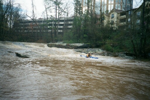
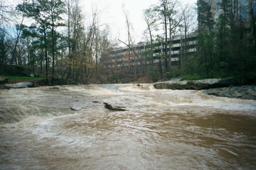
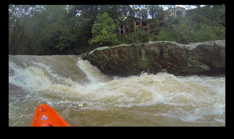
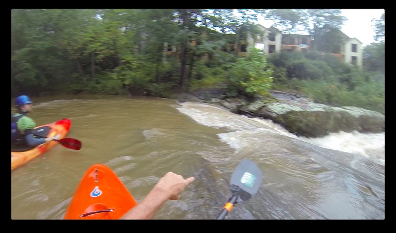
Rottenwood has some fun whitewater rapids ; The Creek flashes quickly after the rain event and the water is often the color and consistency of a chocolate milk shake. The water quality is not always the best so use good judgement on protective gear.
The creek is easy to scout from the small hiking park. There is a very nice hiking trail along most of the creek now.
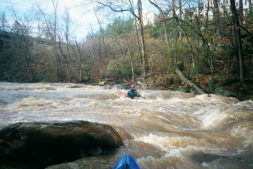
Akers Mill rapid can get into the class 4 range with higher flows.
Above Akers Mill is a nice ledge drop that resembles a low head dam at higher flows. Beware of the undercut left bank. This drop used to be called Confederate Life, named after the multi-story office building beside it. The building has since changed ownership, currently Ascent Insurance. See the Rapids tab for more detailed info.
A word of caution would be to watch out for the large (3 to 4 foot diameter) pipe toward the end of the run. At low flows water runs under the pipe, at flood water runs over the pipe. Last checked there was a lot of wood jammed on the upstream side of the pipe, and not much of an eddy above it. Most people carry around the pipe on river left.
...
A double ledge drop. The left bank is undercut. At high flows this rapid creats a nasty riverwide hole, backed up by a second large hole. At higher flows it can be snuck down the right. At low flows you run down the meat on the left.
Nice little double ledge with a shallow playhole.

Just above the Akers Mill parking area is a riverwide pipe. At low flows it can be ducked under, at higher flows its a hazard with not much of an eddy above it.

After crossing under the I-285 interstate bridges the river turns to the right the back to the left. Scout Akers Mill Rapid on the left. The current is split by a large boulder. Beware or rebar in the approach to the rapid. The standard line is down the right. Continuous Class 3 water follow for the next quarter mile. There are two good play waves in this stretch.
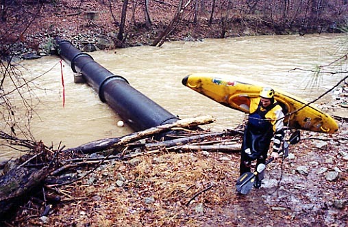
Big riverwide sewer pipe. Lots of wood on the upstream side. Carry on the left.
The take-out is on river right at Palisades Park off of Highway 41.
Feb 18, 2023
I asked on the Facebook Georgia Canoe Assn page about early runs of Rottenwood. Michael B Terryran it in flood in spring of 1973 with Mark Reimer. They were in fiberglass kayaks. They also ran Sweetwater Creek on that day.
Sep 25, 2015
dont go there
Jan 3, 2008
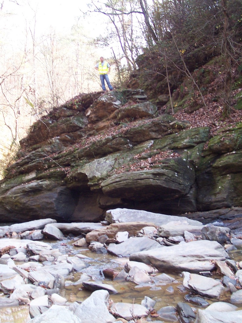
A friend and I ran Rottenwood creek 12-23-07 the level on the guage at the time was 3.5' and was a nice moderate level for our first run on this creek. Before we went to the put-in I thought it might be a good idea to scout Confederate Life rapid to get an idea of the flow and pick our route. After scouting the rapid my friend decides he would help me with the shuttle but didn't feel comfortable about making the run since his experience was limited. With that said it turned into a solo run,which for me always makes things a little more interesting .As previously mentioned this was my first time running Rottenwood, although I had scouted the entire run from the bank with help from the Bob Callan trail which goes right past Aikers Mill rapid , scouting Confederate Life and Windy Ridge rapids are not as easy but can be done by parking on private property. Ok now for the solo run details ;on my approach to Confederate Life in the back of my mind I knew river-right was my best option but from our earlier scout I knew river-left had a nice slide that ran towards an undercut rock with a decent hole at the bottom but it seemed like a runnable line at this level so off I went .On the way down the slide I found myself headed towards the undercut rock ledge so I thought I would use my paddle to brace the impact which resulted in me getting my paddle knocked from my hands which left me circling around the hole until I recovered my paddle then I continued on my way downstream to Windy Ridge rapid where things went a little smoother but not much. There was no swim but it was touch and go there for a second. I was held in the middle of the rapid for a minute, it seemed like forever. Aikers Mill rapid is probably the most technical rapid but for me on this partcular day it seemed to go easier than the other two. After Aikers Mill rapid the creek runs through a small gorge which is mostly boogie water with exception of what I refer to as Bunker rapid (view photos) for a picture of this rapid. There are also several sewer pipe crossings on this run, some actually cross at creek-bed level. They built concrete structures on top of the pipes which resemble small low-head dams the other pipes are aerial crossings which must be portaged . I am aware that solo runs are not recommended, cold weather and nasty water only complicated things but I was desperate for a run and this was my fix . ..Special thanks to Bobby Kelly for the shuttle help.
Nov 1, 2006
Friday, Oct 27, three of us newbies gave Rottenwood a go. We believe the level was around 4 feet. We didn't make it as far as the gage. Confederate Life was a good Class II run on the river right line but a scary as hell looking line on river left that we figured might be a Class IV.
Due to some short sightedness on equipment we did not finish the run. One of our friends was in a recreational kayak and it soon became obvious it wasn't going to work in the fast current and constant action of a creek. I am also to blame as I did not have contacts in that evening and was wearing glasses that had quickly fogged up, so seeing what was coming next was proving difficult. We hiked out and decided to come back better prepared next time.
Also of important note, there is a tree across the river along with a good size pipe just 40 yards upstream of Insterstate North Parkway & 285. You can see both from the bridge where there is currently construction going on and the road formerly crossed the creek on this bridge. Friday night they were right at the level of the water and by Saturday morning the water level had dropped and they were 3-4 feet above the creek. I saw some eddies with fast upstream flows and creating whirlpools along the eddy lines.
We're regulars on Nantahala, love Cartekay, and have hit a few others like Chattooga 3.5 at lower levels but all of these are pool drop style rivers. I wanted to share this little story for others in our skill range thinking about stepping up a skill level the next time the water rises. Going there with inappropriate gear, without a guide and not bridge scouting first was foolish.
The next morning I parked at the Hooch and walked upstream. I was privy to some of the things we would have had to get through including this river wide strainer. The rocks and pour overs (that's the normal low level of the stream) and obstacles we missed down stream looked like fun but I had no regrets about our decision to walk out and come back another day.
UPDATE: Nov 16. The level was a little higher, I took some pictures and built up a webpage. Here is the link and I hope you'll learn from our lessons. :)
Jan 3, 2006
Thought I'd share a hurricane Ivan story.
Meeting up with Jeff Larimer and Neil Quinn it starts at
the put-in where the creek is roaring underneath
Inerstate North. I'm not quite sure how
much rain we got that day, but it was enough to bring
the creek over 10' on the bridge gauge. Now, i have
10' left us speechless and shaking our heads . Neil
was the first to grab his paddle, and without anydone
some runs on this creek at pretty high flows but
words we got dressed.(For the first time we could not
paddle under the bridge, we had to put in below) I
knew from previous runs over 7' that we would have
to walk the first rapid, and that day it was espeacily
nasty. After the riverwide death hole all the water
smashes directly into the trees on river right. We
actually had to walk about 30 yards down stream
before it was safe to put in. Trust me, thoughts of
walking back to the car were sounding pretty good,
but we pressed on. For those who know the run the
following rapid that feeds under the next bridge can
get pretty hairy, and that day was no exception. To
our suprise the lines stay pretty much the same, and
the eddies are still there! GO LEFT, there is a HUGE
hole on the right in this rapid. Then for about 3/4's of
a mile till akers mill just hold on, we are talking big
waves and big fun and plenty of time to get out and
look at Akers Mill rapid. There's really not much to
worry about here, the holes all gone and everything
turns into a huge waves all the way to the river. Even
the rapid further down which normaly has two big
holes is now three incredible surf waves! Now the
only thing in the back of my mind was spotting the
pipes to carry around, but they never came. Somehow
we paddled right over them without knowing, and
when we reached the river, still speechless, we all
agreed that we have never been as happy to see the
Chattahoochee as then.
This has to be my favorite run in Atlanta. Unlike Sope,
which is solid class V+ in these types of rains
Rottenwood keeps its lines and eddies, just a lot
bigger! Not sure of the CFS that day but Sope was
running 7,500 CFS and you could hear boulders
tubbling underwater from about 300 yards away!
See you next time!
Jun 24, 2004
Recently ran it at three different levels:
3 feet on gauge = big water, some pushy water in spots, definitely some holes to avoid. Call it medium-high
6 inches = mellow, but not scraping plastic. all rapids are still fun
-2 inches = minimum level. nothing over class III. still fun for an afternoon fix, but it's not going to get your adrenaline up unless you're a beginner kayaker.
You could still get down Rottenwood if it was even an inch or two lower, but consider -2' your cut-off.
Jan 29, 2004
I ran Rottenwood at 2'2' on the paddler's gage. It was a meaty medium. Based on that single run, I assume that minimum might be somewhere between 8'-12' and high would just over 3'. Having said that, the routes through the rapids change with the water level. Some lines will get easier and some harder, until it all washes out to wave trains and large holes. So, Low, Medium and High is more or less relative. Again, please post your levels and impressions so we can get a handle on the new paddler's gage.
Aug 30, 2003
This weekend I put a gage up on Rottenwood Creek. The gage is on the Interstate North Parkway SE bridge. It is a painted gage on the downstream side of the center set of pylons. It is best viewed from river right next to the large 'Interstate North Parkway 180' sign. In the future when you run Rottenwood, please report the levels and if it was low, medium or high, so we can get a handle on what the gage means.