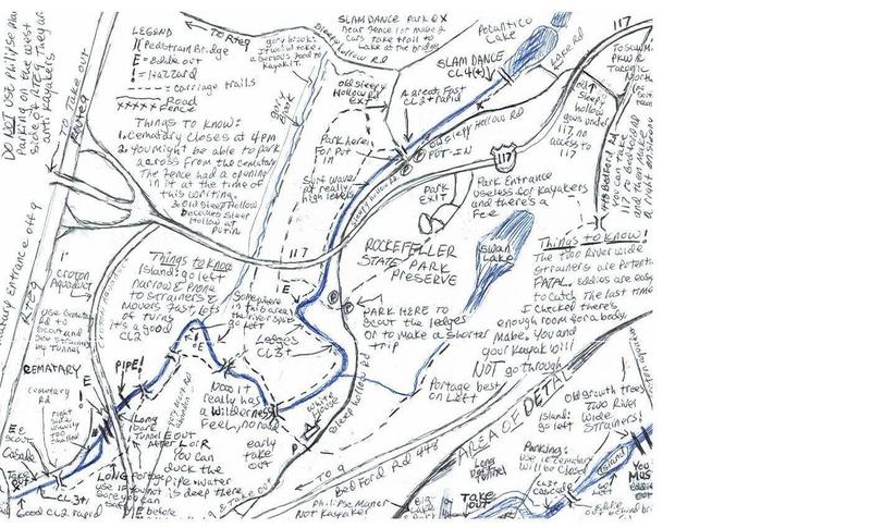
Pocantico
Pocantico Lake to Sleepy Hollow cemetary
| Difficulty | II-III+(IV) |
| Length | 2.4 mi |
| Avg Gradient | 73 fpm |
| Gauge | Ramapo River Near Mahwah Nj |
| Flow Rate as of 27 minutes | 35 cfsbelow recommended |
| Reach Info Last Updated | August 9, 2024 |
This is a small Catskillian stream which floats through Rockefeller State Park.
Paddle Head says that this is like a small Moshier, with 3-4 drops (Class IV) close together, but with room to recover. It's also a smaller stream, but with a sizable watershed and water dropping out of Pocantico Lake, it should retain its water pretty well.
'Jimmy' Dougherty and Tom McIntyre. wonder if maybe they snagged a First D on this one, on Dec. 1, 2006. Tom reports a cross stream pipe just before a dark tunnel that passes under the old aquaduct that carried water to NYC. Jimmy reported must-portage river-wide trees piled up in a large just downstream of the tunnel as you enter into the Sleepy Hollow Cemetary.
From an NPMB thread, begun 12/2/06:
Directions:
From Cold Spring: take 301 east to the Taconic south to the Sprain south. I'm 99 percent certain you can get on 117 and Bedford Rd west. Very shorty you'll bear left off of 117 onto Bedford Rd south? or west? to SleepyHollow Rd. At the intersection of Old Sleepy Hollow and Sleepy Hollow is a put-in option or walk upstream of the river or drive up a few yards (not a good place to park) and start at where the lake pours out. But scout this first drop--it's extreme and the hardest part of the river.
See also the Google Directions from White Plains.
Buck Webb offered alternative directions:
From the North: Taconic to Pleasantille Rd, Turn West (R), 1/4 mile to 9A south (Or just come down 9 to 9A).
Exit 9A at 117, go West (right). Left at first light (448). Firs
...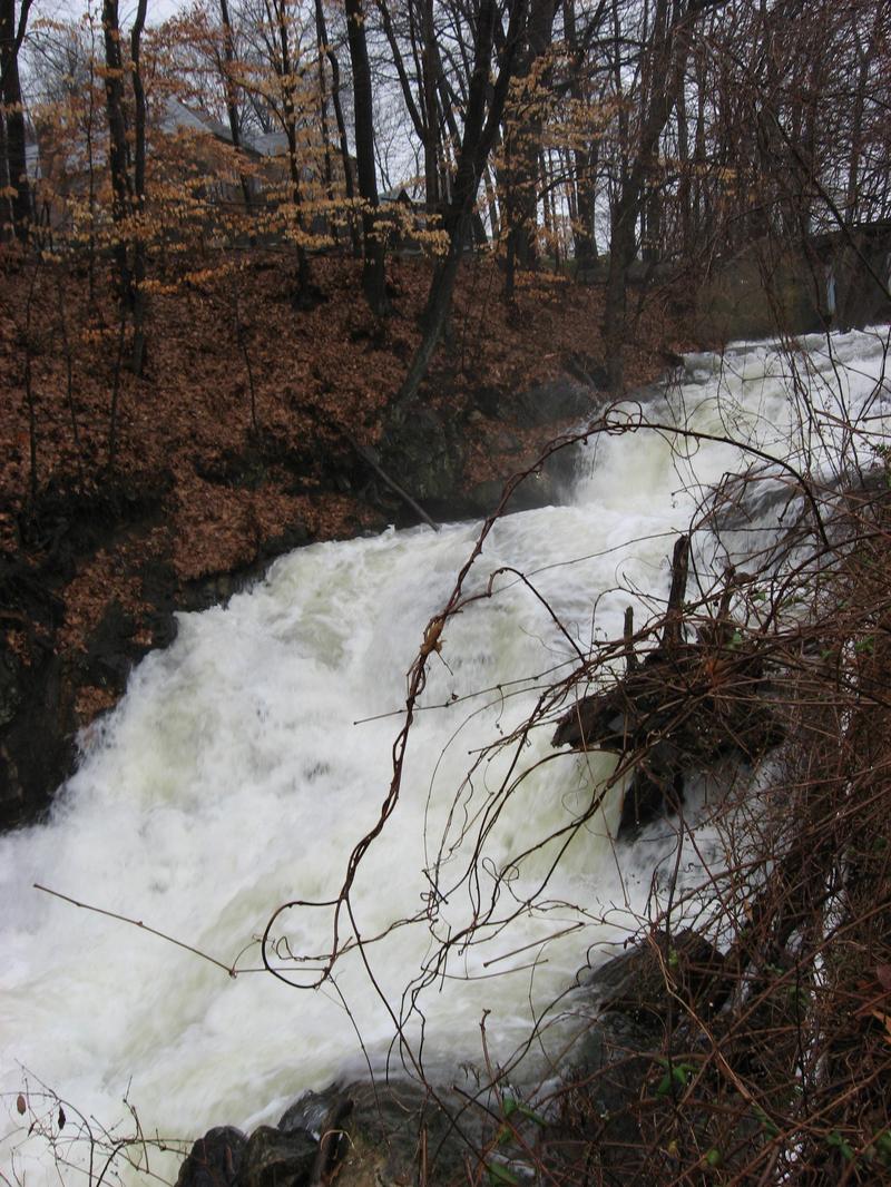
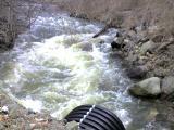
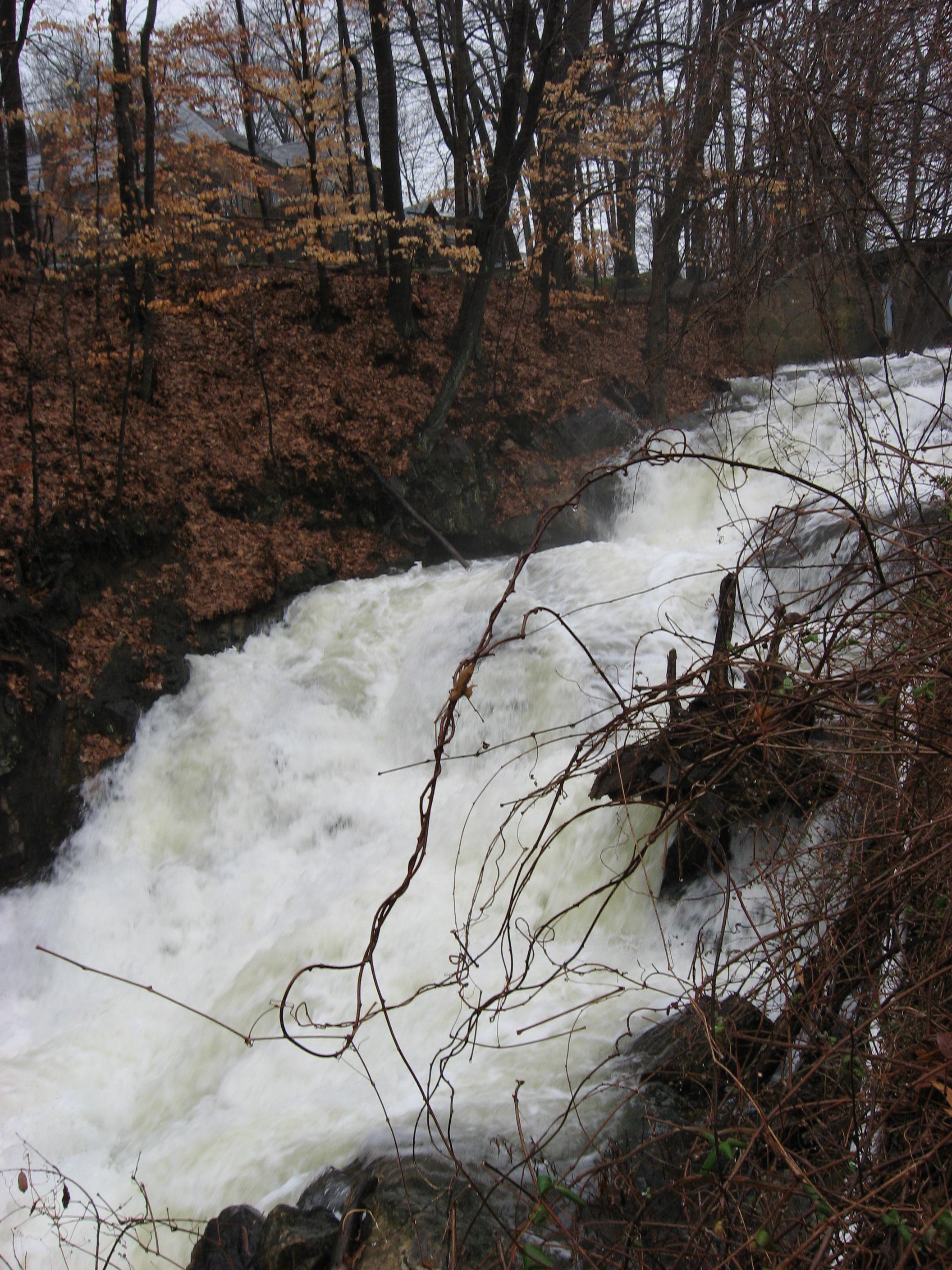
Shown in the banner image on this page. Steep drops coming out of a lake. Most paddlers launch below the waterfall.
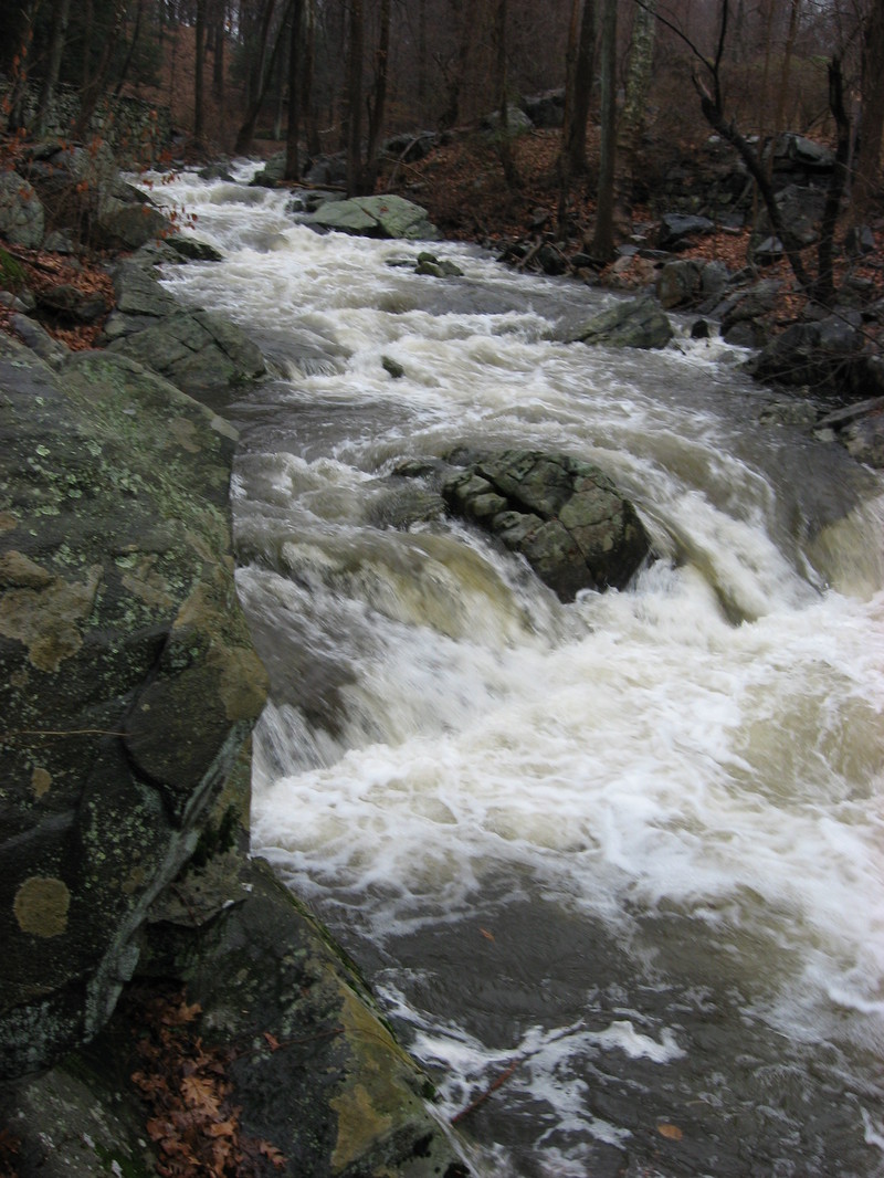
Shortly (40 yards) after paddling under a wooden bottom bridge with iron sheet sides, is a series of steep drops that end at a pool. They are shown in the gallery image that looks upstream to the staircase feature.
Aug 10, 2024
This is a scouting report for the Ledges, a creek-like feature on the Pocantico River. It shows what is probably the minimal level for running it. Paddlers can do 'laps' on this feature by eddying out at the bottom and walking a gravel trail back up. Video with descriptions can be found at this link - https://youtu.be/gdXnnf4Sxeg
One thing to note: The 3.0 on the Croton River gauge should have risen to that level, not fallen. The watershed area for the Pocantico is small. It doesn't stay up for long after the heavy rains. By the time that the Croton Falls to 3.0, the Pocantico has fallen much quicker.
Jun 3, 2012
For Class 2 paddlers: Don't let the rating stop you from enjoying this river. If you start out at the usual put-in, Sleepy Hollow and Old Sleepy Hollow Ext. you will be paddling a mix of flat but fast moving current, CL1 and CL2 rapids with only two small easy to avoid CL3+ rapids which are easily portaged. The CL4+ is above the put-in, you'll have to hike up along side the creek if you want it. Don't park at the small 'pull-overs' above the usual put-in, it's not legal to do so, and there are 'no trespassing signs' upstream of the put-in and I was detained by Westchester Police for being there. The usual put-in is a public and legal place to park. It's unlikely that you'll have a problem parking where you are supposed to be and walking along side the creek upstream to see the big CL4+ slide. From the usual put-in, if you wish to portage the CL3+ spots (there are two of them), when you see a small, cute, rustic paddestrian bridge made of wood and stone, pass under, the creek takes a sharp right, then left in flat water, eddy out creek-right walk up to the paved walking path, walk downstream to the ledges. The secound CL3+ spot is further downstream in the cemetary. When you pass under, or just before you pass under a pedestrain bridge, eddie out. Easy portage on a paved road. Another place you might need to portage, regardless of ability is when you go under a large tunnel due to four river wides trees. At higher water we paddled over them with no problem. Water is flat here. (Note: The water is no longer flat here due to the flood in April 2007 and two of the strainers are now gone. Because the water is swift here now, it is critical to make the eddie just after the tunnel. It's not a hard move for a solid CL2 paddler but you must make this move. A few feet pass the tunnel there are old growth trees that completely block passage. I think you get one more chance if you blow it. The tunnel has small waves at normal levels, at high levels they get kind of big. You do not want to swim here. If in doubt, scout prior to the run. The whole thing can portaged by taking out before the tunnel and putting in after the tunnel. I run the tunnel and portage the strainer only on river left) After which, you need to go left of the island. If there are new strainers, they may present a problem because there's not a lot of room and the stream moves kind of fast here. The secound CL3 spot desribed above is downstream of this. There are quite a few strainers on this creek. Most of which are quick easy portages, easy to see and get out in time. (Note, most strainers now gone be be alert, it dosnt take much to block the entire creek).
Dec 11, 2006
The Pocantico can be paddled from just above the bridge where old sleepy hollow rd crosses the river below
Pocantico lake to the lower end of the cemetary above 9A. The Hagstrom westchester maps show the river pretty well.
http://www.google.com/maps?ie=UTF8&oe=UTF-8&hl=en&q=tarrytown,+NY&z=19&ll=41.104298,-73.846136&spn=0.000829,0.002108&t=k&om=0
This seems to be the area called the Ledges, something like the 'hard' section of New Boston on steriods, the slides and
ledges are bigger and the section longer. I would rate it at the very low water we saw as an easy IV. Thre is easy scouting or carry on the right. The rest of the river is class II, except one drop in the upper part of the cemetary section just after a walk bridge (see map) that is short but ugly.
There is a walk in- path with a footbridge just above the ledges at the point above where the river gets really close to Sleepy hollow road before bending away into the park. On river right upstream of the bridge is a wall remnant. This wall has a top cornice and below, cinder blocks. At the level we ran which has to be considered minimal there were 3+3/4 cinder blocks visible.
Blow-downs:
The river from the put-in up-river to the dam had several trees.
There was a river wide tree trunk comfortably below the ledges just before the hairpin left turn that could be boofed hard left although certain people felt it should be crossed as a group effort and made a party out of it.
After the next footbridge there is a big must carry tree trunk with vines but in flat water. R right was easier carry but left was doable.Jim said this was new in the last couple of weeks. It is rotten and cracked so it may not persist.
Immediately after the tunnel at the aqueduct crossing is a 50 foot section of log jams (must carry) (beaver dam?) There is an easy eddy on R at this level after the tunnel and a steep but passable carrry on river R.
We hiked up into the cemetary to take out, it looked like you could also take out more easily along Dell street on river left above 9A. The whole section along the cemetary was painfully bony at this level, the section above was shallow but OK.
More water could make things interesting in all ways. There are spots blow the ledges and the cemetary nasty drop that could be nice or not waves or holes at higher water. The cemetary drop may be easier with more water.
The whole area is filled with a rabbit warren of paths with a pretty consistant horse path nearby on river right most of the way.
Total time on the river was about 3 hours, with scouting and boat bumping over slow water.
One addendum- after the ledges and there is a point were the river splits around an island. The main flow and route goes left, at least at low water. There is a passable tree down just after the next right bend.