Fossil Creek
02. Classic Section
| Difficulty | III+(IV) |
| Length | 2.5 mi |
| Avg Gradient | n/a |
| Permit | Advance permits are required to park a vehicle within the Fossil Creek Permit Area from April 1 through October 1. During this season and dependent on availability, a maximum of six permits, per person is allowed (one permit = one day). Permits are made available one month ahead of time, on the first of the month. |
| Gauge | Fossil Creek Near Strawberry, Az |
| Flow Rate as of 54 minutes | 55 cfsrunnable |
| Reach Info Last Updated | September 29, 2025 |
Fossil Creek is designated as a Wild and Scenic Area with restrictions for camping, parking and fire. Because this area is being loved to death by visitors, the Coconino National Forest Service has implemented a permit system for day-use access to the river corridor from April 1 through October 1.
Most of this run is alongside a foot trail or the road.
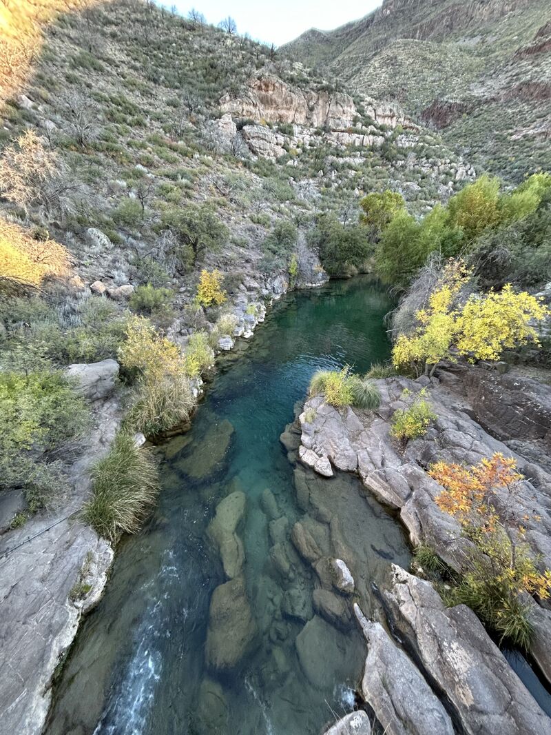
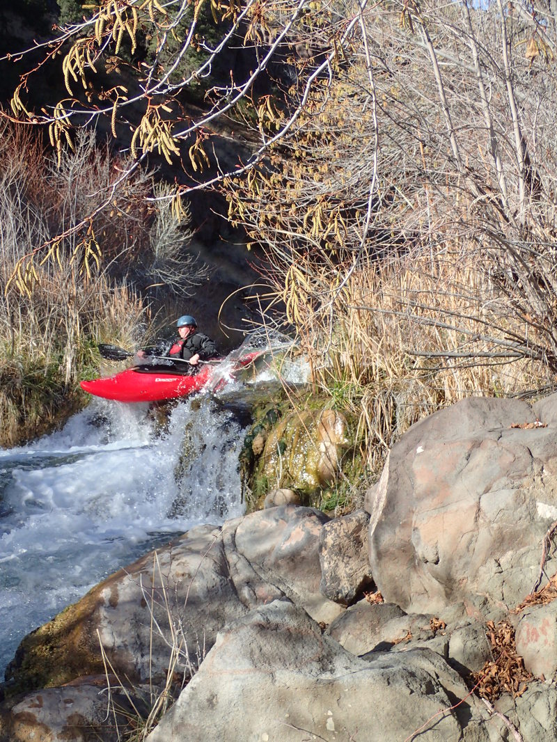
Fossil Creek is the only navigable travertine waterway in the U.S., creating a truly unique section of whitewater. The travertine and limestone deposits create a fun low- water run unlike anything you’ve paddled before. A spring-fed creek with annual flows around 40 CFS, this low volume micro- creeking run holds narrow chutes and several 4 to 5 foot drops or slides. This technical run requires advanced maneuvering/ edging around the unique travertine geology to avoid scraping up your boat/ you.
Logistics:
To access this run from Camp Verde Arizona, head east on State Route 260 and turn onto Fossil Creek Road (Forest Road 708) which is a 14 mile dirt road that heads down to Fossil Creek. As you approach the junction of Forest Road 708 and 502 you will enter the Fossil Creek Permit Area (reservations required for parking April 1 - October 1 for any of the 9 day use parking area).
At the Forest Road Road 708/502 junction, turn left to head upstream toward the run. You will cross Fossil Creek and pass by the two take-out options as you head 2 miles upstream from the junction to the Waterfall Trail Parking area.
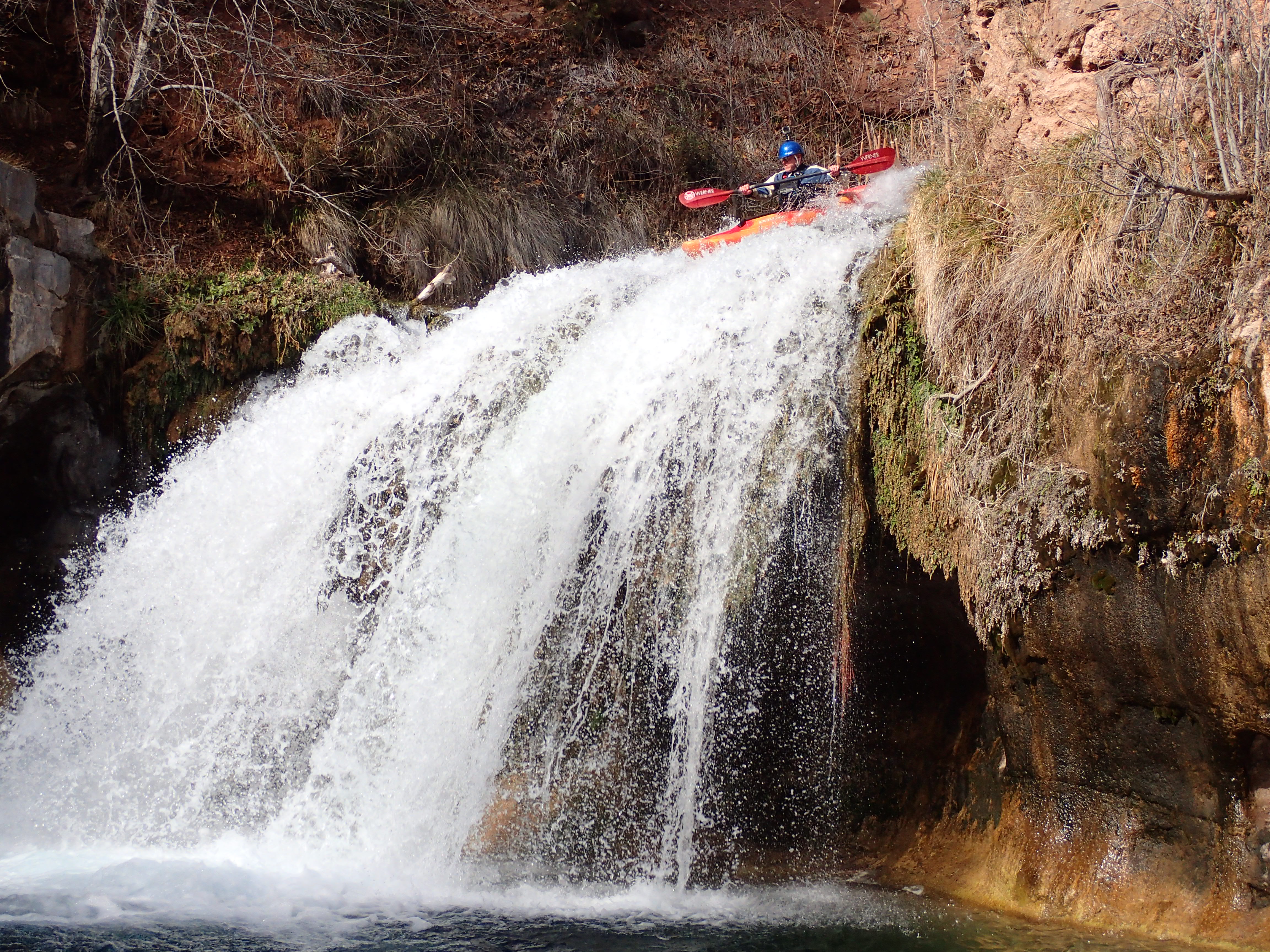
Put- In: Fossil Creek Waterfall
Waterfall Trail Parking (Lot 5) is the preferred parking permit for the run. The start of the run is at the Fossil Creek waterfall, a 20 ft drop in to a crystal clear pool. From the parking area you hike approximately 1.2 miles up the trail to the waterfall. If you wish to run the falls, you need to scramble up 50 ft with your boat, othe
...
An intermediate access point at Powerhouse Falls.
Nov 13, 2024
Nov 13, 2024
We were impressed by this extremely beautiful creek, in a state that has very few paddling options in the fall. The water is ultra clear, flowing through a thick riparian area in the middle of Arizona, it feels out of place in a wonderful way. The pools were full of fish, and while I would describe the many travertine ledges, ramps and slides as 'silly', they were fun in a way children know that adults often forget. Seeing the area from a boat exceeded the already cool way of seeing it from shore.
At base flows around 50 cfs, I would not describe the whitewater as quality, though it did have it's moments. If you want quality whitewater, you need more than baseflow, around 150 cfs Iv'e read. If you just want to see a really cool place from your boat, base flow is fine.
Despite the small size making the whitewater less than great, I really appreciated the run and would definitely do it again, even at base flows. We used packrafts, but I would prefer a hardshell boat next time for better sliding and stronger material.
We went after permit season and camped at the Homestead access point.
Jun 6, 2024
I ran part of this run at 44 CFS. I'm going to be honest, while this has some fun and low consenquence drops, it's mostly low quality mank. At base flows it barely fits the definition of runnable. On one rapid early on, an overhanging tree branch pushed me sideways, I went down a rapid sideways, got my packraft pinned, and I ended up swimming a really boney rapid head first on my back, got a really nasty bruise on my lower back. Most of the rapids on here are the type of mank where you bounce around on rocks and barely make it down without getting stuck. I've done plenty of scrapey micro-creeking, but I found this one particularly not fun. Not reccomended. It might be a lot better with 100 cfs.
Mar 23, 2010
I ran this yesterday from above the power house falls downto the bridge. Somekayakers ran the falls, but being in a canoe i portaged. The whitewater was constant, and very technical. one blade would make me rate it a III+ to a IV without hesitation. I ran into a lot of deadfall. BE CAREFULL! The drive there is sketchy, fossilcreek road goes through the drainage, and the Strawberry side is slightly faster and a lot cleaner.
Feb 8, 2010
Jerry Lovett 2/6/10 Ran the classic section from the 20 footer (not a 15' like the description Say's) to the power house yesterday at double base flow, probably 100 CFS. Perfect level! A big flood cleaned up the one pin rock we used to avoid and made it a perfect III chute, it's a whole different creek now. This is a fun creek run all year but if you can catch it a high flow it's a blast. Look for about 130 CFS on the West Clear creek gauge.
Jul 31, 2008
We talked to a Forest Service ranger and he said that they were going to close this creek off to kayakers soon. So here goes another public area that the government is going to restrict. Their reasoning is that kayakers damage the build up of mineral deposits in the river. Kayak this while you can. It is fun!
Jun 29, 2008
I believe this is a 3 mile run if you go from the put in to the take out at the power plant. It is probably a 14 mile run if you go all the way to Verde river.
It is a mega fun run though... except the 2 mile hike in. Scout each rapid for debrie and pinning rocks. There are 2 bad pinning places that I know of.