Crystal
Chain O' Lakes to Little Hope (Wayside Park) (5 miles or PnP)

| Difficulty | I-II |
| Length | 3.5 mi |
| Avg Gradient | 10 fpm |
| Gauge | Tomorrow River Near Nelsonville, Wi |
| Flow Rate as of 40 minutes | 25 cfsbelow recommended |
| Reach Info Last Updated | May 16, 2025 |
Quick Facts:
Location: Approximately 6.7 miles SW from Waupaca.
Shuttle Length: 3.7 miles.
Character: A shallow stream with (generally) clear water (fed from a lake) has areas of shoals and plenty of twists and turns.
Put-in is approximately 890' elevation (mean elevation of Long Lake/Chain-O-Lakes).
Take-out is approximately 843' elevation (at the Mill Pond in Little Hope).
Thus total elevation change is approximately 47'.
General Overview
The first (and often only) 'whitewater' experience many Wisconsinites (and Illinois vacationers) get is a trip to 'Dings Dock' to paddle a funky fiberglass (nearly see-through) canoe down the Crystal River. Such trips are common for family groups, youth groups, school groups, et cetera, for a bit of summer fun. Trips start (rather interestingly) with a motor-launch cruise across a lake (the river flows out of the 'Chain O' Lakes'), towing the fleet of canoes to the head of the stream.
The intimate stream has numerous tight turns and various rocks and shoals for novice boaters to navigate, though the biggest 'hazard' on the trip will be your fellow boaters, as they delight in ambush and sabatage, to have splash fights and attempt to capsize others' craft. Apparently the former mill dam at our listed take-out has been officially abandoned, and may provide some minor play (as shown by our feature photo above).
Any private boaters who opt to run this reach are therefore advised to do so either before Memorial Day, or on week days, to avoid the vacationing novice throngs.
For those interested in a longer trip, the confluence with the Waupaca River is another 7 miles downstream, at just under 800', making this lower stretch average just about 6 feet per mile.
We had 'pegged' this section to the USGS gauge for the Waupaca River near Waupaca to have some online reference to indicate likely water levels. Unfortun
...
Drainage area at our listed put-in is approximately 46 sq.mi. (as calculated via USGS StreamStats Beta software).
At the Main Street bridge, a large island splits the river. The more direct (and likely preferred) route is the left channel.
Many folks may prefer taking out here, skipping the remaining flatwater to the pond and dam.
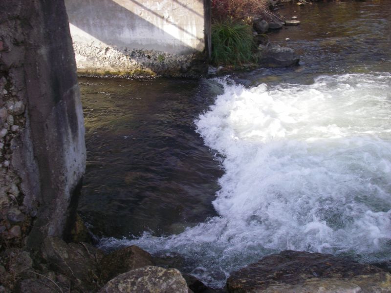
A short dam with an overhead walkway precluded any likelihood of running. As of late 2014, we have information suggesting this dam has been abandoned and may now be paddled though, allowing some minor play at the base of the outflow.
USGS lists a sampling site near here with drainage area of 82 square miles, so flow here could be about twice the listed gauge reading.
This marks the end of the listed reach, however anyone so inclined may continue downstream to the remaining lower gradient stretch of this river.
Nov 2, 2014
The now defunct dam (~2012) at the takeout has a small play feature, somewhat shallow. Did not get a chance to play as we were in canoes.
Oct 29, 2014
We canoed this and found the dam to be out of commission near the takeout, for 2 years according to a resident on the old impoundment. However, there appeared to be a decent play wave at the old dam site, which offers a nice park and play from the park/takeout across the road. The 16' coleman was in no shape to do some play in late October, so for now it looks like a tame play wave, and a little shallow. Since it is a park n play I figure someone will eventually check it out. I put a picture up as well from a later date (11/2/14).