Buck Creek
Buck Creek Rd. to 7/10 MI N. of Hwy. 2 (3.4 miles)
| Difficulty | II-III+ |
| Length | 3.3 mi |
| Avg Gradient | 42 fpm |
| Reach Info Last Updated | April 24, 2008 |
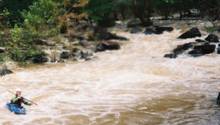
Buck Creek is is a long creek with a large watershed, so will run for a few days after a big rain event. There’s little gradient, and no whitewater, until it approaches the put-in listed here. The run is short, just over three miles, but it’s pretty much non-stop right from the put-in. At lower levels, you’ll find yourself maneuvering to pick your route through the shoals, and at high water, you’ll find a lot of energy in the big pushy waves.
Most of the run is characterized by almost continuous, steepish shoal-type rapids.
Buck is a fun run. It has a shuttle length of about eight miles one-way; with less than three miles of that on dirt roads. After making this run you just might find yourself at the takeout wondering 'Is this really Oklahoma?'
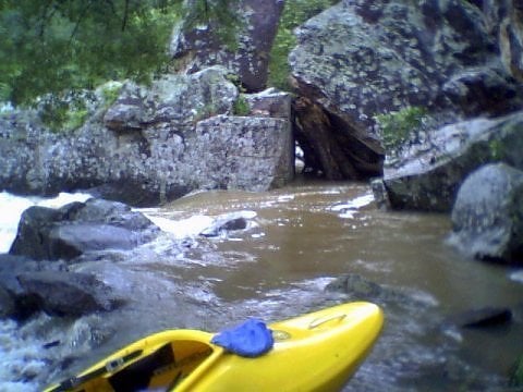
Access: Like the other runs in the area, Buck runs near and through private land and has quite a few residences near the creek and its access points. Please be friendly and respectful of the land and local residents.
Take-out:
(34.347567/95.650235) From the intersection of Hwy's 2&3 just east of Antlers, go about 7.3 miles north on 2 'till you see the Buck Creek Bridge. Just south of the bridge , take the dirt road to the west that runs upstream along the creek. Go about 7/10ths of a mile, and just before the road crosses a small low-water bridge, there’s a park-like area on the right with a gravel circle drive.
Private Land!
At this writing, it is okay to park here, but please check in with Mr. Duncan, the landowner who lives in the wood house across the low-water bridge at the takeout (upon arrival - and before doing anything else), and let him know you’re paddling and want to park there. If he's not there - leave a note! He’s fine with it as long as he knows what you’re up to. Just be sure to keep vehicles on the gravel and don’t drive down to the creek’s edge. Stay on the road or
...
Long shoal with lots of rocks.
Open the gate, let 'er buck. No warm up here. From the very start the ride is fast and rocky. At high levels be prepared for some big waves and a good bit of rock - dodging. At lower levels get ready for a whole lot of rock dodging. River narrows toward the end of the shoal giving way to a runout rapid with a nice wave train.
Creek drops steeply to the left, then makes a hard right. Look for a surf wave at medium - lower levels, and some really big standing waves at higher flows. From the beginning of this rapid through Standing Rock, the creek forms a horseshoe bend that drops sharply for about three quarters of a mile. Lots of power, energy and big waves through here at higher flows; hang on for a buckin' good time.
Look for a house sitting right at the creek's edge on river right. Creek drops to the right, then hooks a quick left; where another small stream comes from behind the house. Water pushes toward a large boulder here.
Boulders with small drops in between. Just around the bend from Zaggety-Zag, water pushes hard toward a big rock on river left. Wind through these and start looking for some huge boulders (Standing Rock) just beyond a short pool.
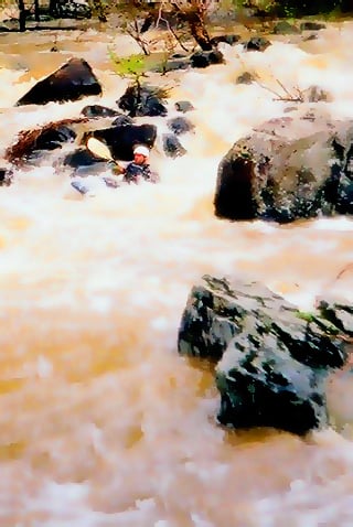
Just beyond Rok Shoks, you'll see some large house-sized boulders on river left. Use plenty of caution here, and stay away from the large house sized boulders on the left as the slots tend to collect a lot of wood at times. At high and low flows, and on first runs; bank scouting from river right is advised due to the large number of big rocks in this area, and clear lines being difficult to see from the boat. In fact, there really is no really clean line through this rapid except at high water, and even then I really don't think you could call it a clean line. Penalties could be pretty severe if you get upside down in at any time on the middle 'line' of this rapid (8-10' boulder drop.) At medium to high water you can sneak this one on river right with a little maneuvering; and a portage is probably going to be necessary at lower levels. Just beyond this rapid hook a quick left to avoid getting hemmed up in the brush.
Long bouncy rapid with nice waves, several fun class II's beyond this one with the last class II rapid being immediately above the takeout.
Jul 2, 2009
My name is Stephen Henley and I own the land just above the put in with the red gate. Since I too am a boater, kayakers are welcome to park in front of my gate and camp on my place if they wish. All I ask is that you give me a call first in case I need the gateway to be clear for access to my property. If I am there, please stop by to say hi. My # 214-505-5461. ~Stephen
Jul 14, 2007
Middle Line, House Rock Rapid
Jul 30, 1913
Middle Line on Leaning Rock Rapid
Look closely at the center of the rapid, you can barely see the paddler there.