Bruneau
Indian Hot Springs to 8 miles South of Bruneau
| Difficulty | II-IV |
| Length | 40.6 mi |
| Avg Gradient | 30 fpm |
| Permit | Self issue permit can be downloaded from BLM website, and are available at self registration stations at the put in and take out. |
| Gauge | Bruneau River Nr Hot Spring Id |
| Flow Rate as of 50 minutes | 33 cfsbelow recommended |
| Reach Info Last Updated | June 13, 2026 |
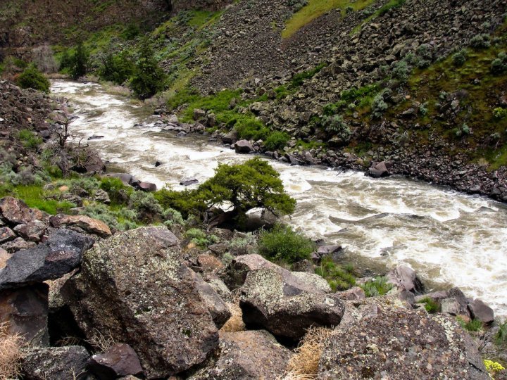
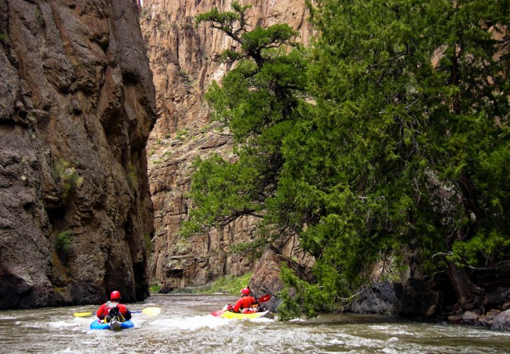
FUN FACT: Great kayak self-support trip of 3 days (3-5 days if combined with the Jarbidge) through a remote wilderness canyon. Recently designated part of the National Wild and Scenic Rivers System.
SEASON: April / May
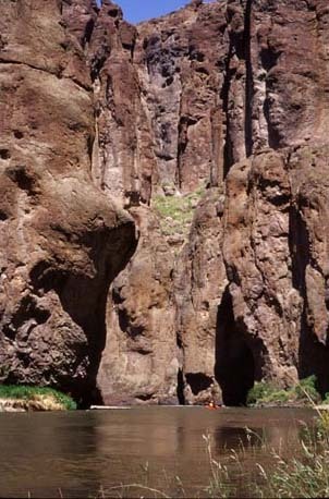
HAZARDS: Possible log jams. Poison ivy and rattle snakes. Vertically-walled gorge with limited exits and access. Remote wilderness. Difficult shuttle. Rapidly fluctuating water levels. Long continuous rapids at high flows. Unrunnable low-head diversion dam just below take-out.
Take Out: Head Southeast from the town of Bruneau for 8 miles on Hot Springs Road. Where the road veers left and climbs, watch for a gravel road that continues straight along the river (note that the name also changes here on the map from Hot Springs Road to Clover Three Creek Road). Follow it 1/2 mile to the take out (private land). There is a dangerous low head dam immedeately below the take out that is difficult to see from river level.
Put in: The traditional put in for the Bruneau is at Indian Hot Springs, just below the confluence of the Jarbidge and West Fork Bruneau Rivers. Driving there requires a capable 4x4 vehicle with good, mud-terrain tires and an experienced off-road driver. Two spares tires and high lift jack are highly recommended for travelling the Bruneau backcountry. The drive should not be attempted during wet or snowy weather, which is frequent during boating season. To get there, turn off approximataley 30 miles out the Clover Three Creek road (measured from the take out). Watch for a sign on the right after crossing Clover Creek and making a large switchback turn. The first six miles of the road are good, but don't be fooled, it quickly deteriorates into ten miles of treachery thereafter. As a general rule, stay left at the unmarked forks, and mark your turns to avoid getting lost on the way out. There are no landmarks in the flat Sagebrush plai
...Jun 6, 2020
June 6 2020. Log blocking Right channel at Kendells Cave, the 1st drop on Bruneau, left of big rock is clear.
May 17, 2020
We ran it on 5/15/20 to 5/16/20. We ran two 16 ft oar rigs, one 16 ft cataraft, several kayaks, two sabertooths, one 14 ft paddle raft and one 13 ft oar rig. The river level started at 850 when we put in and ended at 750 when we took out. Spent a lot of time in five mile getting the big boats unstuck, several pins etc. They are just too big at this water levels for all but really experienced boaters who already know the lines. All the boats less than 14 ft had minimal issues with rocks. Yes there was a lot of rock dodging but still a great experience for the smaller boats. Anything less than 900 leave the big oar rigs at home. At this water level five mile is pool drop rapids in succession. When it gets over 1500 those pool drop rapids disappear and they form a continuous wave train. I know they called wild burro a class IV and it is but you cant scout it easy and you don't need to. You will bounce off the wall at low water levels in a larger boat(bigger than 15ft) and at high water the standing wave wont let you hit the rock since the water pillows up. The real action is below the scary wall. Once you deal with the wall the action is below with several rocks to miss but you have plenty of time in smaller boats at this level. Above 1500 all those rocks go away and its a sheer joy to slide off the pillow and into a long wave train. This is by far the easiest read and run IV on the river but its super fun.
Jul 21, 2019
We were fortunate to score a Bruneau run in July - we put in at Indian Hot Springs on 7/2/19. The flow at the USGS Hot Spring gauge was ~730 cfs and that was plenty sufficient for our self-support group of 2 kayaks and 1 pack raft. Because we squoze this run into a 7-day trip that also included the South Salmon, we only had 2 days to paddle Bruneau. I wish we could have spent more time in this incredibly beautiful canyon! At this flow, most of the whitewater felt like III-III+ with a couple rapids that ramped up to IV-. Road report: the road to the PI is still in pretty terrible shape. We were expecting some less-than-ideal roads and for it to become very slow going once we got to the rim of the canyon, but the rough road conditions started a good 10 miles before we got to the rim. We considered parking at the canyon rim and carrying our boats to the river, but the decision was made to drive all of the way to the river. You really need high-clearance 4x4 for this portion of the road. There was a small wildfire on the other side of the river and we encountered a BLM vehicle driving out of the canyon along this already sketchy section of road. Thankfully, we only had to back up about 15 yards to reach one of the rare places where it’s wide enough for two vehicles to pass each other. If you decide to drive all of the way down the road and there’s any chance you may encounter and oncoming vehicle, it’d be a good idea to send somebody down on foot to negotiate with the other drivers. After we unloaded our gear and ate a late lunch, the decision was made to drive the truck back up to the canyon rim so we wouldn’t have to deal with the steep portions in the dark during the post-paddle shuttle. After the driver and his scout hiked back down to the river, we put-in after 5pm and probably made it 15 miles before camping. After the run, I waited with our gear at the take-out while the others retrieved the vehicle at the canyon rim. The round trip took them 4hr 20min! They say the road to the Jarbridge PI is well-maintained. If you have more time than we did and the Jarbridge has sufficient flow, definitely consider that option so you can avoid those gnarly roads.