| Difficulty | III+(V+) |
| Length | 1.6 mi |
| Avg Gradient | 190 fpm |
| Reach Info Last Updated | July 25, 2024 |
River Description
Put in is roughly near lat/lon: 58.46113, -134.74767. As mentioned below walk up till you hit the first clearing. Follow the boardwalks until they start heading uphill into the woods. I recommend changing into your dry suit when you hit the meadows. Peterson Creek crosses under the glacier Highway at mile 26. There are allegedly three red spray painted lines on the upstream river right side of the abutment that mark the minimum and maximum flows for the run.
AKA 'Bliss Creek'. This run is Fish Creek without the stress. 5 to 7 straightforward drops, clear lines, easy scouting and portage. Peterson Falls marks the end of the run. Don't miss the take out! it is a 50+ footer into a shallow pool. Drag your boat up the Peterson Creek trail and put in at the top of the last meadow, about 2 miles in.
River Features
Put In
Access PointDistance: 0 mi
Take Out
Access PointDistance: 2 mi
Trip Reports
Log in to add a reportAP
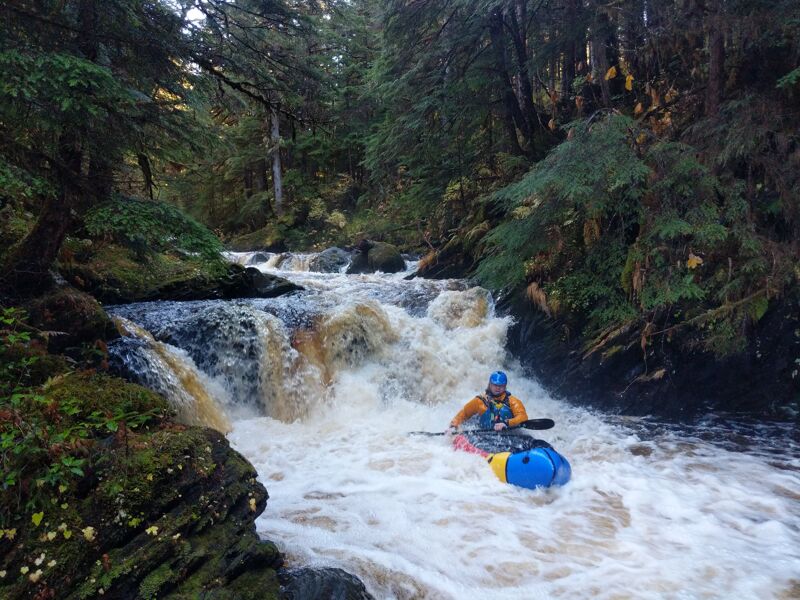
Andrew Park
Jul 25, 2024
I took this photo off the Juneau whitewater group. Sorry not sorry. Great photo.
AP
Super chill put in to 1/2 down - Andrew Park
Jul 18, 2024
Ran the upper half and had to get out early due to time constraints. Super chill and super fun Class II to Class III+. Plenty of room to scout and portage if you want. Beta we recieved indicates the pace picks up further downstream with some class IV moves.
While these rapids are chill with easy moves, there are some strainers, sieves, and undercuts so scout before dropping. Plan 6 hours from parking lot to parking lot.