Henrys Fork
Hatchery Ford to above Upper Mesa Falls(Sheep Falls Run)
| Difficulty | III+(V) |
| Length | 6.9 mi |
| Avg Gradient | 44 fpm |
| Gauge | Henrys Fork Nr Ashton Id |
| Flow Rate as of 1 hour | 2180 cfsrunnable |
| Reach Info Last Updated | August 1, 2022 |
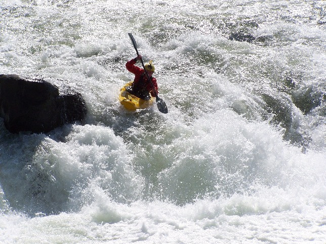
This run is a beautiful canyon consisting of mellow class II-III whitewater and three class V drops.
The old Idaho guide book describes this as a scenic run with three portages. Other people think of it as a fun run with three good rapids and some flat water. Either way it is beautiful and worth the effort. Also, generally runs all season.
From Hatchery Ford to Sheep Falls there is a class III rapid called 'Chips flip'.
It is one mile from hatchery ford. It always has wood on the left so run it right.
Portage Sheep Falls river right.
We call the second drop 'Son of a Sheep Falls'. The put in for the portage is right after this. Follow the trail down a small cliff to a big ledge to another small cliff. The climb down is is worth it and lets you hit almost everything after son of a sheep falls. The place you stand is always in water from 6 inches to a foot and a half deep but its always there. Its safe and almost always is in an eddy.
Mile 3.0 is Toilet Bowl rapid. It's short but its really swirly at high water and less so at lower water. If you catch it right its really fun and if not it flips you.
At mile 4.0 is Cottam's Curve. At lower water levels the line is left with a hard curve to run to miss wrap it rock. This is really only hard for rafts. At levels above 1600 CFS you can run the rapid anywhere.
The third drop is called Gun Site Falls since you line up the boof rock and go for it. The bypass is on the right and there is a clear trail there and the best place to scout the rapid.
From Mile 5.2 to 6.1 is a long series of wave trains called screaming eagle because there always seems to be bald eagles there.
An alternate put in for the run is to put in right at Sheep Falls.
Sheep falls road is signed of highway 20 approximately 15 miles from ashton near mile marker 370. Follow the road down till you come to forest road 760 and turn left there. The road dead ends to a trail that is a sho
...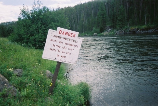
To get to the put-in continue towards Island Park. Turn left when you see a sign for Hatchery Ford. Follow this dirt road down to the river. You will know you are in the right place by a sign warning of dangerous falls downstream and that boating is not recommended.
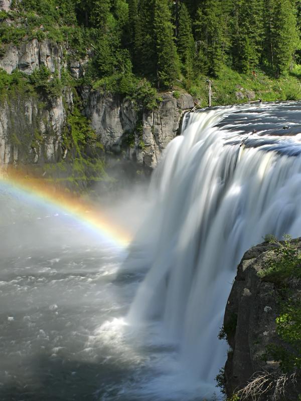
Take Mesa Falls Scenic Byway (Idaho 47) from Ashton, ID. Continue past the Lower Mesa Overlook and turn into the Upper Mesa parking area. This is the takeout, note it is a fee area. Unless someone in your group has run this stretch you should take the time to stroll down the boardwalk and scout the takeout. Potentially the most dangerous part of the run, this is not a takeout you want to miss. You will want to float onto the shelf of Upper Mesa, eddy out river left, and step out of your boat onto the boardwalk.
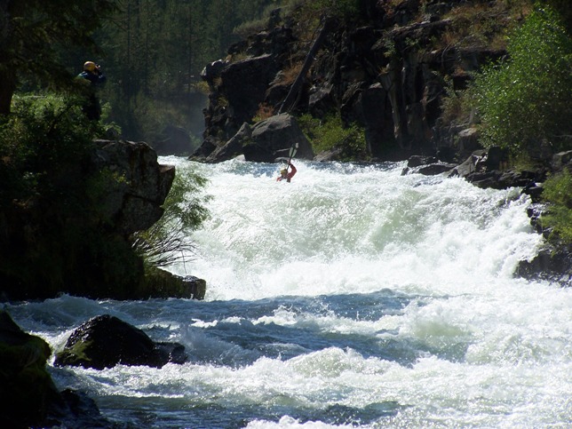
Sheep Falls is located on a sweeping left turn. Noticeable by a significant horizon line and a hint of spray. Eddie out river right to scout and/or portage. Both the two-tiered part of the drop on the left or the slide on center right are runnable.

This rapid is immediately after Sheep Falls. Easiest to scout both while you are out of your boat, or if you are portaging, just keep walking. This drop is as intimidating as it is safe. Take note of the two small entrance holes. They are bigger than they look from the bank. Otherwise, straight down the tongue, baby! Huge, flat pool at the bottom, minimal consequences. Under 1600cfs this drop gets very sticky and is not usually run. Over 2500cfs it only gets better! When portaging there are two possibilities for re-entering the river. The best is to slide off a rock at water level into the current right below the meat of the drop. People have seal-launched the high rock, but you run the risk of breaking your boat on the underwater rocks. If you do not like the look of this: hope you are wearing long pants. You will be hiking for a while, navigating a steep embankment, and wading through waist-high stinging nettle.
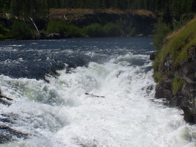
Look for another horizon line on a left curve. Scout on river left; portage from either side, but easier on the right. There is a guide rock on the lip of the center-left of the drop. Boof just to the left of the rock and head right to avoid a hole. Note: If the guide rock is underwater, BEWARE. The left wall is undercut and at this level water is pushing into it. Unlike Drop No. 2, this rapid is not overly intimidating, but has potentially high consequences in high water.

This drop is a river-wide, sticky, ledge hole. It can be run anywhere if you have a good relationship with your boof stroke. Otherwise, run left. You can see the drop from the river left eddy. This hole has been known to re-circulate swimmers and empty boats.
Class I if you make it, class VI if you miss. Do not float over Upper Mesa Falls! Exit river left onto the boardwalk and smile at the tourists.
Jul 17, 2024
I would like to point out that none of the drops on this section are remotely class V. In technical nature and consequence. There are certainly hazards in each of the two larger drops, but overall it should be considered a class IV run in my opinion. For aspiring class IV paddlers as well. A great run all around!!
Nov 10, 2005
The Ashton gage is the ACCEPTED gage for this run. There is not a 'correct' gage. The Island Park gage does not include the flow from the Buffalo Fork (which is often larger than the Henrys Fork itself at Island Park). Theoretically, the flow from the Island Park gage could be added to the flow from the Buffalo Fork. The problem is that the gage on the Buffalo Fork is above the confluence with Lava Creek. Lava Creek does not have a gage, but guessing by the picture above, it might be significant. The problem with the Ashton gage is that it also includes the flow from the Warm River.