| Difficulty | IV-V+ |
| Length | 4.3 mi |
| Avg Gradient | 185 fpm |
| Gauge | Richland Creek Near Witts Spring, Ar |
| Flow Rate as of 1 hour | 0.74 ftbelow recommended |
| Reach Info Last Updated | February 23, 2018 |
River Description
Very steep Ozark creek with big drops, lots of pin potential, undercuts and wood to watch for. Some drops offer large powerful holes. Portages & scouting can be long and difficult.
Total Run is 4.3 miles with a total drop of 800 feet = 185 fpm average gradient
Upper Gorge is 0.5 miles with total drop of 200+ feet (400+ fpm)
Lower Gorge is 0.6 miles with total drop of 200+ feet (330+ fpm)
Each gorge has a 0.25 mile section topping 500 fpm.
The upper gorge is fed by a just over a square mile watershed.
The lower gorge is fed by over 4 square miles.
Very impressive and unique features including 'Landbridge' and 'Punchbowl Falls'.
Put-in can be reached via an old road 0.5 miles NE of Dickey Junction (intersection of Newton County roads 5080 and 5085 aka Richland Creek Road and Richland Road).
The top of the lower gorge can be accessed via the Ozarks Highlands trail from Richland Road.
Take-out is reached by following Newton County 5085 that changes to Searcy County 12 (Richland Road) to the North toward Eula. Just after descending the hill and passing the cascade on the left flowing off the NE side of Stack Rock, look for the first road to the left (Hoot Owl). This is located just before the access to the Lower Richland Creek takeout.
Follow this road around the hill to a NFS gate overlooking some wildlife game fields next to the creek.
When looking for the takeout from the creek, note when the creek flows into and under a large bluff on river left. The bluff is about 100-yards long and overhangs the entire creek. Takeout at the end of the bluff on the right and hike up to the gate.
There are some roads below here, but all on private land.
River Features
Put In
Access PointDistance: 0 mi
Drainage: ~1.1 square miles
OtherDistance: 0 mi

At the listed put-in drainage area is ~1.1 square miles (as calculated by USGS StreamStats 4.2.0 software).
By the listed take-out it has increased to ~7.58 square miles.
Upper Falls
HazardWaterfall / Large DropClass: VDistance: 0.4 mi
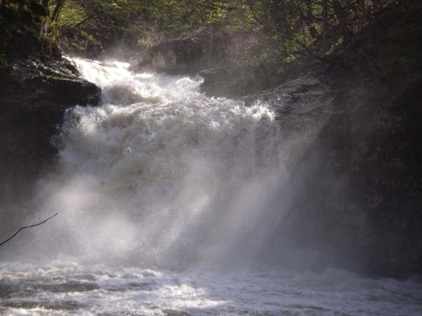
30-foot waterfall into a small pool.
Upper Gorge
HazardClass: VDistance: 0.45 mi
Steep, tight manky drops follow below the 30-ft waterfall. Pin potential and wood are likely in this section. Keep an eye on the eddies as the lead-in to 'Landbridge' is just around the corner.
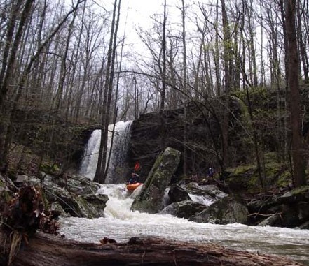
'Landbridge'
PortageHazardWaterfall / Large DropClass: V+Distance: 0.8 mi
Steep multi-tiered drop under a natural bridge formed by a large slab rock spanning the creek. The entrance drop has pin potential, the middle drop corkscrews off the right wall and the bottom drop offers more pin potential and an undercut left wall. This drop is the end of the upper gorge.
The entrance
Under the Landbridge
Last drops of landbridge (photo from top of the bridge)
OHT
Access PointClass: IV+Distance: 1.6 mi
Ozark Highlands Trail crosses at an old road and signals the start of the lower gorge. Boulder garden drops start to get steeper and more continuous.
Lone Ranger
HazardClass: VDistance: 2 mi
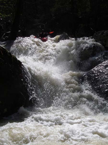
Immediately below a 4-ft ledge, a steep muti-tiered boulder drop awaits. Stay away from the smaller left side which lands in sieves. The run-out of the drop leads into the next drop 'Highway to Hell'.
Lower Dry Creek Falls
HazardWaterfall / Large DropClass: VDistance: 2.15 mi
The entrance contains and undercut boulder and sieve, followed by a fast slide through a reactionary wave just above the lip of the 20-ft waterfall. A shelf sticks out 5-6 ft from the base of the drop so make sure you can launch into the deep pool.
Entrance to the falls
The falls
Tonto
HazardClass: IV+Distance: 2.25 mi
The run-out from the pool below the falls leads to a large boulder in the middle of the creek. The left side offers pin potential, the right side a little less so. Boof the ledge on the right with hard left angle.
Take Out
Access PointDistance: 4.3 mi
Trip Reports
Log in to add a reportLJ
Lance Jones
Apr 10, 2008
Upper Gorge below the opening 30-ft waterfall
Entrance drops of 'Landbridge'
The Landbridge
Looking downstream from the top of the Landbridge at the bottom drops
Multi-tiered boulder drop in the lower gorge
Entrance sieve and undercut to the lower falls
Lower Falls with lots of water. 20+ ft drop on the slide into the 20-ft waterfall
First rapid below the 30-ft waterfall of the upper gorge.