Fox (Illinois R. trib.)
B) Waterford/Rochester/Burlington (PnP)
| Difficulty | I(II) |
| Length | 0.46 mi |
| Avg Gradient | n/a |
| Gauge | Fox (il) Approximation at Case Eagle Park, Rochester |
| Flow Rate as of 39 minutes | 113 cfsI(III)low runnable |
| Reach Info Last Updated | May 25, 2025 |
Quick Facts
Location: Case Eagle Park, Rochester
Put-in/Take-out/Parking: 42.7357, -88.2248
Shuttle Length: 100 yards (walking, from parking lot to below dam at river's edge)
Character: A single (or multiple) wave in the outflow of a dam (and, alternatively, an area of shoals).
- - - - - - - - - - - - - - - - - - - - - - - - - - - - - - - - - - - - - - - - - - - - - - - - - - - - - - - - - - - - - - - - -
Drainage Area: 767 square miles
Nearest whitewater runs (alternatives/'daily doubles'): White (Lake Geneva), Root (Racine), Milwaukee (in Milwaukee)
Whitewater rivers with most similar drainage area: Baraboo (609 sq.mi.), S.Fk.Flambeau (609 sq.mi.), Eau Claire (Little Falls to Big Falls, 760 sq.mi.), Milwaukee (in Milwaukee, 696 sq.mi.)
====================================================================
As with a great many 'low-head' dams, to prevent scouring of the riverbed, there are large rocks throughout the outflow of the dam. If you flip, it is extremely likely you will suffer a hard hit on one or more of them. Thus, it is hard to recommend playing these features unless you are a highly experienced playboater, justifiably confident in your ability to surf the features without flipping. (We also might recommend a full-face helmet (chin-guard/face-guard), elbow/forearm pads, and maybe even shoulder pads for anyone opting to play here!)
Notes regarding gauge/flows/playability for these features:
Unfortunately, it is very difficult to know what conditions will be present without actually going for a first-hand look. The 'virtual gauge' on this page is not reliable nor sufficient to ensure playability at any of the features listed here -- it's merely an indicator (and it's the best we can do online). It uses a USGS gauge many
...
The left-channel (in Waterford, around a large island filled with condos) has a uniform-lip cement wall/dam, from which water spills into a shallow, rocky outflow. Since pool height is regulated by the main dam (in the other channel), there would rarely (if ever) be enough flow here to cover the considerable amount of shallow rock to allow any chance at passage (or any sort of play) in any paddle-craft.
(NOTE: subsequent to this photo, the rocks have been pushed up closer to the base of the dam.)
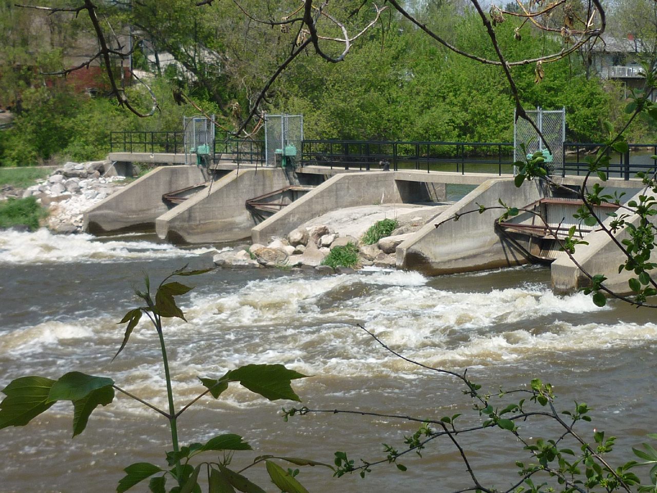
The main dam has two releasable lift-gates. Water sheets horizontally across the cement slab of the dam, then pours off that slab into the pool. Air pockets form behind the flow (creating a lighter root-beer-colored effect) before it meets the pool below. This 'curtain' of water pouring into such a chaotic 'hole' in the pool would make for extreme likelihood of flipping. The entire pool is filled with large rocks which will be just below the surface at virtually all flows, meaning all experience-levels of boaters should never consider playing the outflow from this dam. While the wave/hole might (at some flows) look like it could be surfable/playable, any flips would almost certainly result in bodily impact with rock.
Canoeists and recreational kayakers often put-in below this rocky area to paddle the 'pond' between Waterford and Rochester, and (posiibly) to paddle an 'up-and-back' on the Wind Lake Canal which enters the (Illinois) Fox just upstream of Main Street, about a half-mile upstream of the dam in Case-Eagle Park/Rochester.
Park as far south as possible in the main lot (by the Jean Jacobson Dog Park).
Since conditions are quite unpredictable here (I.E., you can't rely on color coding), we recommend walking down to the dam to have a look before suiting up and carrying down.
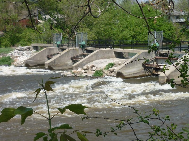
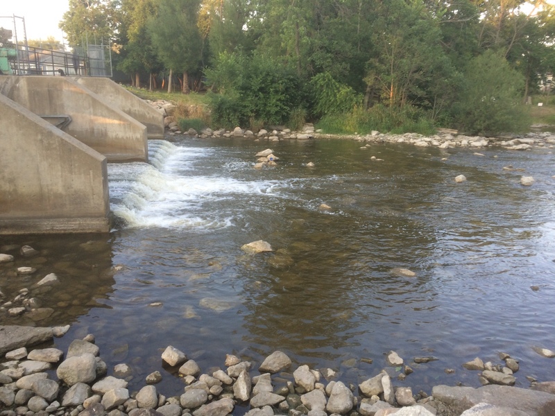
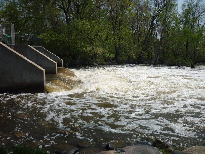
Case Eagle Park in Rochester (about 0.38mi. downstream of CTH.D / Main Street) has a dam with four main release gates at center river (which are controlled by Racine County). The left-most part of the dam is a spillway/overflow area with a series of generally evenly spaced (narrowly enough to barely fit a boat through) metal rods standing vertically from the cement slab. In the past, these supported planks standing edge-wise, to increase the pool height just a bit, though I haven't seen them in place for years now. Between the spillway and the release gates lies slightly higher arching cement slab. Down-slope of this area is filled with large rocks. (Water is virtually never allowed to pass over this area, but even if some freakish flooding would cause this area to have water, passage by any watercraft would be impossible or at least strongly inadvisable, as it would likely cause boat damage and possible bodily harm.)
Water passing under the left pair of gates sheets swiftly across cement before hitting the pool below. At times, sweet looking wave/holes form where the flow hits the pool. However, the riverbed in this swift outflow is littered with large boulders to limit scouring of the riverbed. Any whitewater boater attempting to play the outflow will regularly encounter these rocks with their paddle and likely with their boat. Any flips or swims here would be brutal! Thus, whitewater playboating here is very highly NOT recommended unless you are sufficiently skilled and justifiably confident of staying upright!
Water is seldom released from the right pair of gates, but when they are in use (whether or not the left gates are also open) the outflow generally does not form features nearly as good as when only the left pair of gates are in use.
There are times that wave/hole gets a bit 'frothy', increasing dramatically the likelihood of flipping and suffering a 'close encounter of the worst kind' with the rocks in the outflow. Each paddler must decide their comfort level ... you may wish to wear a full-face helmet, elbow-pads, shoulder pads, hockey gloves, ....
Access for the Calumet Channels from river-left is possible from Bushnell Park. Enter the south part of the park and immediately go left (southeast) to parking area for a ball diamond. Walk due south to cross through a brief wooded area to get to a dead-end stub of the White River Trail (former railroad line), then proceed west to the (gated off) bridge. A steep slope to either side will allow you to look at and access the leftmost channel(s) of the river.
The main parking to access the Calumet Channels is at the Burlington Dog Park. Park as near the river as possible.
You can 'preview' the rightmost channel by walking a narrow footpath (between the electrical substation and the river) until you get to the former railroad bridge. Depending upon your interest, you can walk a bit downstream through shrubbery along this riverbank. Years back it was possible to cross the bridge to scout each of the channels, but the bridge has fallen into such disrepair that it has been gated off (at both ends). (Adroit individuals may still circumvent the fence to cross the river and get a look at the other channels, but that is at your own peril.)
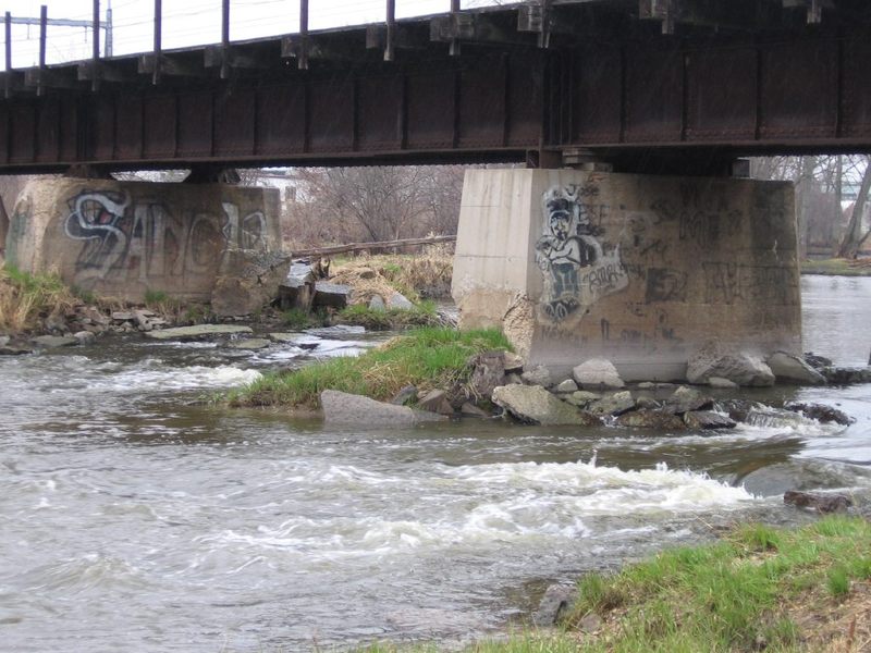
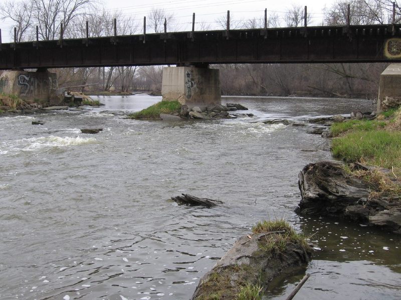
Just beyond downtown Burlington (9.25 miles downstream from the dam in Waterford, 7 miles downstream from the Rochester Case Eagle Park dam), the Fox River spreads wide (approximately 110 yards/330 feet) as it threads between islands and passes under a (defunct) railroad bridge.
As previously detailed, this area is accessible on river-right (west bank) from the end of Calumet Street, where there is parking for a fenced-in dog-walk area. (Hmmm, does that make this a 'bark-and-play' spot?) Alternately, on river-left (east bank) this is accessible from Bushnell County Park.
As of summer, 2016, the defunct railroad bridge crossing the river here has been fenced off at both ends (likely due to a combination of vandalism, time, and neglect, resulting in concerns regarding liabilities). This makes it extremely difficult to scout this area before just boating it. Anyone who bothers to boat this area (I.E., to explore it fully, not just downriver passing through), will likely find it necessary to beach on various islands and shores to carry up and then (at the end or your attempted play) to return to whichever shore you began, to carry back to your vehicle.
The river is split into a number of channels -- three more-or-less 'main' divisions made by islands before the bridge, with each of those channels then split in two or three by bridge piers. A total of 7 bridge piers make 8 channels (though at least one of those is exclusively a high-water/flood channel which will be dry land most of the time).
Each channel contains a different amount of the flow of the river (obviously) and has differing rock/rubble clutter, creating differing potentials for play. Some channels are relatively tame (worthless) at virtually all flows. At low flows (under 500 cfs on New Munster gauge, or under 250-275 cfs on our virtual gauge) there is not likely enough water in any channel to provide any play (or much depth -- you will scrape across the rock and gravel bottom through most of these channels). The whole area washes out at high flows (above 1000 cfs or so on the New Munster gauge ... around and above 550 cfs on our virtual gauge), making virtually no reason for being there. Levels between (roughly) 500 and 1000 cfs may provide some minor play, but don't expect too much out of this area.
The right-most channel (actually, pair or channels, split by a bridge pier) contains the greatest flow (perhaps nearly 30-40% of the flow of the river). The eddy immediately behind the bridge pier has pretty fair depth (for possible vertical moves -- bow stalls, stern squirts). As the river quickly shallows downstream, a couple minor riffles (possibly a surfable wave) may exist before the end of the islands where all channels reconnect.
The left-most channel (again, actually, pair of channels, split by a bridge pier) probably is the second largest (perhaps 25-30% of the flow of the river). Rocky constriction (under the railroad bridge) and shallow bottom combine to create strong current through here. A potentially surfable wave may form at flows in the higher end of our 'recommended flows', but at low-to-moderate levels the shallow rocky shoals not far downstream will virtually preclude any repeat play here.
The remaining 'middle' channels are all much smaller (10-15% or less of river's flow). These are likely to be the better play available (such as it is) at this location, as they (surprisingly) have a bit more of a 'pool' immediately below the bridge (allowing for easy repeat play) and generally lack the shallow rocky shoals found in the larger right and left channels. At the lower range (of cited 'runnable' flows) they may provide some easy surfing opportunities (front-surfs, side-surfs, and flat spins).
It may be noted that (upon a few visits here, years back) there was some evidence of modification ('rock stacking') in some of the channels. These manipulations will be nearly futile here, as any attempts to pool-up or constrict flow in any channel (to modify and create a playable feature) mostly just results in the other channels getting some additional flow. Even more relevantly, any rock capable of being moved by human power will, with virtual certainty, be moved by the river (especially every spring, at 'ice-out', as massive sheets of ice bulldoze their way downriver). As well, any rock-dam creates 'scour' immediately behind itself (especially here, since there is mostly soft, erodable riverbottom). In what is likely to be a very short timeframe, this erosion will cause the rock-dam to collapse into the scour pit. (Your rock-dam will create it's own demise unless you also ‘armor’ the river bottom downstream of it with substantial rocks, which you are unlikely to do!)