Otter Creek (Ohio trib.)
U.S. 60 to Firetower Rd. (6.3 miles)
Nov 23, 2011
Run this creek for the first time today. Unsure of the CFS rating due to the guage not currently working but I would estimate it between 600-800 possibly a little higher.
The surf wave at the put in was awesome. We didn't play much due to a late start and it being our first trip, but will plan on spending some time there next trip.
We encountered probably 5-6 more really nice small surf waves, one that reminded me of 'church wave' on the elkhorn. The run is short but almost non stop wave train at this level.
The only negative is the get out is not very well marked. Not at all basically. We missed it and ended up almost in the ohio. :) Hopefully the park will put up a new sign. If your planning on making your first trip soon I'd suggest a GPS to mark the get out or hike the trail down to the creek and hang something in a tree.
Also note if you park at the blue hole parking lot its a .5 mile hike out.
Feb 10, 2011
Latest news is Otter Creek Park will re-open spring 2011 under supervision of the KY Department of Fish and Wildlife Resources. A new fee system will be applied to help cover costs.
Mar 26, 2009
Please note that public access to Otter Creek via Otter Creek Park is no longer available. The park was closed in January 2009 by its owner, the City of Louisville. The city announced that it will prosecute anyone entering the now-gated park. The city states that it will not reopen the park, but it is trying to find either a private contractor or another government agency to open and run the park. This was a great facility for boating, hiking and mountain biking. Let's hope it does reopen.
Aug 21, 2006
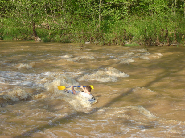
I ran this creek at 2000 CFS and the big surf wave washed out, and the waves were much smaller. Basically it was washed out allot and it’s way more fun at 900 CFS. We had a blast at the park and surf thanks to the two boofs, and we surfed in our rafts behind them for about 7 hours of the day as the creek drained down to 1300 CFS. The boof on the left side of the creek is the most fun and easiest to catch, but has a sharp sword like rock behind it that has sliced open two of my rafts so far. At 1300 CFS the big surf wave wasn’t that big at all. There is now a huge sign on a rope that crosses the creek saying Blue Hole at the takeout, and it points left. Somebody told me that the park ranger advised them not to go at such a high level, and I think it’s because the current is much swifter at this level.
At 900 CFS a park ranger told us: “you better not get swept in to the Ohio River, and make us have to do a swift rescue for you two”. We told him that this creek is simple compared to Elkhorn Creek and we know exactly where to take out; at the huge eddy named blue hole, and he said nothing more. I bet they have had to do rescues with all the inexperienced tubers that go on this creek.
Me and my brother went Hiking and Rafting at Otter Creek, and my brother made a huge fully detailed webpage about the trips, and it has tons of pictures of this park. All the rafting pictures are at a level of 500 CFS:
(update) I fixed this link:
http://www.rotteneggs.com/r3/show/se/184184.html
-Note-
To view the webpage above: Copy the URL(http://www.whatever.com) and paste it in your web browser's Address bar, and press Enter
Jun 8, 2006
5-02-06
I ran this creek at 700 CFS as it drained down to 500 CFS. At 700 CFS there is a great surf wave at the putin, it has the best re-run value of any rapid I have ever seen. You only have to walk 10 feet to put back in and catch the wave again. The surf wave at 500CFS splits in two, but I was able to surf it one time still from one end to the other. The boofs at 500CFS start to show exposed rock, there much better at 700CFS. The rest of the trip was not too exciting, but there are tons of wave's, and it was a much different experience compared to Elkhorn Creek. It was like being in the ocean for most of the trip, but we only saw 4 more rapids and most were small. I did however love the gorge, and I thought it was overall better than Elkhorn's. For the takeout we parked at Cedar Hill, and exited the creek at bluehole and hiked not far at all to Cedar Hill. It is only about a 2 hour trip on the creek this way, but leaves us plenty of time to play around more at the puttin(park and surf).
WARNING: There was a creekwide strainer (huge logs from one end to the other) right after Blue Hole. It is only a strainer when the CFS level is 600 CFS and below, and at 700 CFS water flows over it and it's runnable. The Gauge, Pictures, Video's(at 500CFS), and a detailed map, are all listed below:
-Note-
To view the pages below: Copy the URL(http://www.whatever.com) and paste it in your web browser's Address bar, and press Enter, enjoy:
Me and my brother went Hiking and Rafting at Otter Creek, and my brother made a huge fully detailed, 5 star BLOG with pictures, and video's of us at Otter Creek; playing in the surf wave (at 500CFS), Hiking, and my brother even tips over boofing in one video:
http://www.rotteneggs.com/r3/show/se/184184.html
------------------------------------------
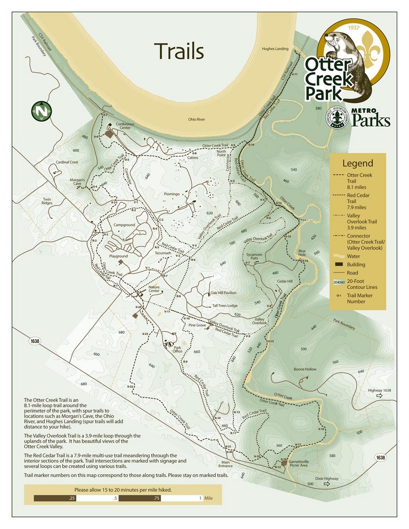
Here is the URL of the Otter Creek Park's Official Trail Map:
------------------------------------------
Mar 6, 2004
From US 60 to KY 1638, Otter Creek runs through the Fort Knox Military Reservation. In January 2004, I wrote to the commanding officer at Fort Knox and asked permission to kayak that section of Otter Creek. On February 24, 2004, I received a letter advising me that my request was denied. The letter cited two concerns: (1) disruption to adjacent military training, and (2) safety issues due to three low-water crossings and two dams.
Mar 22, 2003
Aron Smith - Scouting report for Saturday, 3/22/03.
Section 1: Putin at Otter Creek Park - below the HWY 1638 bridge. No gauge on this section, estimate water level to be approx. 1 foot today. Minimum amount needed to float the 2.6 miles of class II white water. We experienced several portages due to fallen trees.1st approx. 1 mile from putin; another just past the fire tower take out
Jan 1, 1900
You can't acctually drive up close to blue hole, it is a little ways of a hike up that cedar hill to where I normally park. I think if you go all the way to the end; you have to go down the ohio for a minute to get to the boat ramp(where parking is), but you could hike out Otter Creek Trail, but it would be quite a long walk I bet.
This is the boof on the left side of the creek at the put-in/park and surf. At 500 CFS it's a scrape, and 700 CFS is much better. At 1300 - 2000 CFS there is a nice sticky hole behind it that we like to surf in, and I even flipped 3 times that day, and hit my head once. We normally ALWAYS where are PFD's, but we forgot when we went to take these pictures, because we got distracted.
Jan 1, 1900
My brother acctually crashed right through this rapid in his raft, but I'm sure a kayaker can surf it because I have done it in my raft a few times. At 500 CFS the wave splits, and I was even able to surf from one side to the other catching the other half of the wave. At 700 CFS it's great, and me and my brother thought it washed out a bit when it was at 900 CFS. This is the best rapid I have seen on this creek, but I haven't been all the way down it yet.
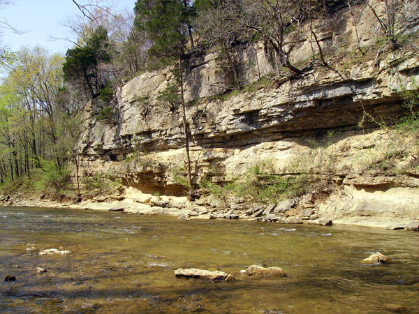
This part is right before blue hole, and right at the end of it there is a ledge that's only on the right side, so don't miss it.
First there is a small drop with a little white water, and then the whole creek washes up on this undercut bank. It is undercut by at least 10 feet and would pose a threat to any tipped kayaker I would think.