Cold
Route 2 hairpin turn to Deerfield River
April 4, 2021
| Reporter | David Hoddinott |
Ran this at 3.5 feet on Deerfield Fife gauge.
Decent run, we took a small raft down, and it was too low for that. The kayaks got through with a bit of scraping.
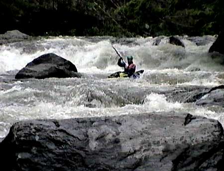
Most of the river is decent Class II - II+, and was fun in the kayak. There was one obvious class 4 that only two of us ran, the left line worked out best (this looks like it will change with higher water). There were a couple swims and one minor pin, be ready for rescues, it's rocky. The class 4 has an easy place to set safety and scout. You might have an audience, there's a pull of from the road right next to this.
In several areas of the river, it looks like the banks have had some sort of concrete poured on them, possibly it ran off from road construction, or possibly to prevent erosion. The concrete eroded below the waterline, so in several areas, river right looks quite undercut, with a very sharp concrete edge.
We took out at the railway bridge, about 1/4 mile downriver from where AW says to take out. There was a small lot. The area that AW has on the map looks like it would be easier to carry boats through, but the roads say no parking near there, although there may be room for 1 or 2 cars near the bridge. Another good place to take out might be right after the class IV, on a place google maps calls 'aire de repos' (Rest area). It's a small pulloff with a big sloping rocky area. You'll miss the last half mile of whitewater, but nothing too crazy happens there.