Trip Reports
Log in to add a reportJE
Jared Espley
Mar 14, 2019
As of February 2019, the whole creek is blocked by construction just above the main rapid. The whole river goes into some impassable culverts that go under a construction bridge. It was fairly easy to spot in advance and a relatively easy portage. The iron pipe above the main falls (mentioned in the description above) seems to be gone as part of the construction.
C
Chris
May 22, 2012
As of May 21, 2012 at 2pm.......There is a river-wide strainer at the steel pipes, which are located just below MD-40. The root base of the fallen tree is still attached to the bank on river left, so it looks like this strainer is here to stay for a while. You may be able to sneak through on river right at low water. Easy portage is on river right directly under the huge arches of the MD-40 bridge. Take out amongst a knee high pile of garbage, then climb an easy staircase of broken discarded concrete, up to the railroad tracks. You can make a steep descent to put in immediately below the pipes, or continue 100yds further down the RR tracks to where you can easily (and safely) get down to the water's edge to scout the falls and the ledges just below. The eddys are easy to find, they are the areas filled with floating, swirling garbage. It's a damn shame this wonderful river is painted with garbage.
C
Chris
May 19, 2012
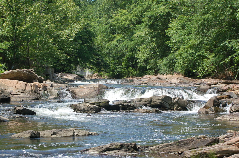
Gwynn Falls ledges just below the falls. Low water, 23 cfs, .98 ft stage.
C
Chris
May 18, 2012
The Falls on Gwynn Falls. Low Water, 23cfs, .98ft stage.
RS
Robert S. Farmer
Aug 22, 2011
We've been having some intense isolated thunderstorms lately, with hard rain down by the harbor, so I thought I'd check out Gwynns. I drove to check the gauge at Washington Blvd, and it was at 7.0! I drove up via Dead Run, and it was raging-----scary-high! I got to the put-in at Dickeyville, and the water was barely above the minimum. Long story short, most of the water was coming in from Dead Run and points downstream----Dead Run almost doubled the volume!! From Dead Run downstream, the level was nice (4.0), above that, it was rocky and abusive. Fun fact! FYI.
RS
Robert S. Farmer
Jul 16, 2010
I caught this 7/12/10 at about 3.9 ft. (at Wash. Blvd) The rainfall pattern on this day is kind of illustrative of a semi-typical summer pattern: The rain started falling pretty hard (2+ inches in @2.5 hours upstream) after a dry spell at around 2:00 p.m.; at about 4:20, it peaked at 9.3/4600 (Villa Nova peaked at 4.5/800), and by the time when I finished the run (7:38 p.m. at Wash. Blvd.) after putting on at 6:30, it had dropped to around 3.8---still good, but getting low. Hence, there was only about a 3.5-hour window of runnability, less if you're not willing to paddle crazy-high water. Also, the log that was on the right side of the first left bend is now about 1/2 mile downstream on the left. You can get by it, but it is hazardous, so watch out! I paddled from Dickeyville to Swann Park, near Hanover St. in 1:58, not rushing. It took only 41 minutes to get from Dickeyville to below the Route 40 ledges, including a portage around the pipelines. A pretty enjoyable afternoon!
RS
Robert S. Farmer
May 25, 2010
The Washington Blvd gauge can be read online at:
http://waterdata.usgs.gov/nwis/uv?01589352.
For those of us who like to paddle down to the harbor sometimes, Swann Park has now been reopened, just off Hanover St., next to I-95; it makes a good takeout, especially for me, since it's an easy walk to my house from there.
?
Untitled
Dec 3, 2009
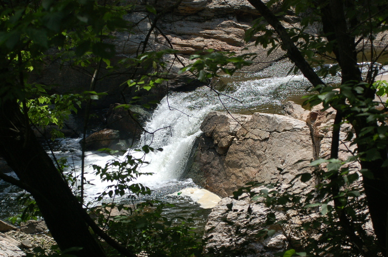
Robert Farmer---It is probably safest to run the last ledge on the left at high water; you have to zig and zag a bit. Beware of the next-to-last ledge at all levels---the middle part is a keeper, and the right side has an extremely narrow line---safest to go left, for sure! Also, watch out for the piton rock on the right side of The Falls, and there is a barely-submerged rock just downstream of the landing zone that also should be considered. Watch out for the ledge hydraulic---it is very grabby at times. Hey, who ran this without me? If anyone wants to run this sometime, call me at 410-624-6421. I'm glad to see that someone else is finally enjoying MY favorite local creek! I missed it that day. . .
?
Untitled
Oct 28, 2009
Ran this section on 10-28-09 with relatively high water conditions (400cfs). I'd recommend advanced boaters to put in just below the dam at Dickeysville as this eliminates all but one portage (the low pipe below Edmondson Ave) and features the heaviest whitewater section. At this level the right slot of upper Gwynn's Falls is a safer drop than the left option, just manuver to the left of the roostertail. The final big riverwide ledge about 1/2 mile further downstream should also be run on the right about 5-8 feet left of the protruding rock just before the drop itself. You can take out on Frederick Avenue on the right if you want to avoid the remaining flatwater and don't mind a more strenuous climb vs. the remaining. takeouts.
?
Untitled
Oct 19, 2009
Robert Farmer---Gwynns was running all weekend 10/17 and 10/18. On 10/18 (Sunday) it was up around 2000 cfs at Washington Blvd and was quite enjoyable. I portaged the double pipeline on the left, which seems to be the best way---not the right side, as mentioned on the main page. I put back in on top of the concrete block that forms the end of the pipeline. Even though I spent about 24 minutes scouting and portaging, the whole trip took only 1:25, so I spent about an hour actually on the water. It was really very good.
?
Untitled
Oct 16, 2009
Robert Farmer---So, the other day, I tried to count and remember the rapids. I counted 25 rapids from Dickeyville to Washington Blvd---the best section---but I could remember only 21 by the time when I went to write them down. No matter---there are only a few of significance. You put in to Rapid #1, below the drowning machine dam at the park at Dickeyville; the best spot is on the left side of Salamander Run. Currently, there is a log on the right side to watch out for. You pass under a small bridge and run a small slide (Rapid #2). A couple of small rapids leads to Rapid #5, the first crux. The creek makes a sharp left turn; start far right at low water and work far left. After Rapid #7, you come to Windsor Mill Rd bridge. Rapid #8 is immediately downstream, and has a bridge pier just left of center, which is submerged at higher levels. Rapid #9 is a potentially DANGEROUS ledge, probably man-made, where you should stay left; the right side has a bad hole. At the bottom, Dead Run enters on the right. Soon, you pass under Franklintown Rd. bridge. Rapid #11 has an island---stay left; the right side is too shallow. After a 90-degree left turn, you come to a 90-degree right turn where logs tend to create hazards---currently, it is open. Now, if I've counted correctly, Rapid #12 is a pipeline immediately downstream of the Route 40/Edmondson Ave bridge that you should be very careful about. I've described it elsewhere, below; currently the left and right slots are open, but not the center. Scout! Rapid #13 is the crux, a 5-6-foot ledge that is serious almost all of the time---Class 4-to-7, depending on the level. The hydraulic is very sticky. Scout carefully. There is a piton rock on the right side, and the launch current kicks leftward, encouraging a stay in the hole, which could easily be fatal at most levels. On my most recent trip, I screwed this up, when I should have known better; I made it through---just not gracefully. Rapid #14 is just downstream---a tombstone-shaped rock sits blocking the middle of the river. I always eddy left, then, at low water, I ferry to the right, while at higher levels, you can go left or right. Downstream a few hundred yards are 2 ledges---Rapids #15 & #16. The first one is safest on the left, although it can also be run TIGHT right; Do NOT Go Down The Middle!!! That hole definitely looks very dangerous!! At the second ledge, I boof the right side at lower levels, and run the far left at scary-high levels. Scout! Soon you come to a rapid underneath the Baltimore St. bridge. Everything from here on down should be self-explanatory. Have fun! I hope to see some other paddling party on this run someday!!
?
Untitled
Oct 16, 2009
Robert Farmer---I caught this yesterday 10/15/09 after a moderate rain of about 8 hours, with possible nighttime drizzle of around 12 hours prior to that. I had mistakenly thought the Washington Blvd gauge read 2.8, with the level rising at Villa Nova, far upstream. I put on at 5:40 p.m. and finished at 6:57 p.m. (Dickeyville to Wash Blvd) for a total low-water time of 1:17---perfect for an afternoon, although everyone else will take a bit longer. (Sunset was at about 6:28, but I made it past the crux rapid just about then.) The hydraulic at the main ledge just downstream of Route 40/Edmondson Ave was sticky---I hit it badly, and it was a bit scary, even at this low level---treat it with respect, always! The level at Washington Blvd when I took out was 2.5, just above the absolute minimum of around 2.3---I had wondered why it seemed awfully rocky for 3.0---it wasn't 3.0! Villa Nova was at around 160. The new gauge system reads much more frequently than before, and is much more useful. A delightful afternoon!
?
Untitled
Mar 30, 2009
Robert Farmer-- I caught this the other day when the Villa Nova gauge (I found out later) indicated around 1.25 ft/ 50 cfs; this turned out to be an abusive minimum. Total time from Dickeyville to Wash. Blvd.: @3 hours. I paddled it once before at @70 cfs at VN; this was slightly less abusive. An acceptable level for many people might be around 100 cfs, but the gauge is far upstream, so this is only a rough indicator rather than a true water level. The stated minimum of 150 would be well-padded, but less frequent. I noticed a new visual gauge at Washington Blvd---the only visual gauge that I know of. The abusive-minimum level here is 2.5. A good minimum would probably be 2.75. 4.2 is very nice. Because the telemetric gauges are read only once a day, and the creek can easily rise and fall in 6 hours, the telemetric gauges are often not helpful, except for later reference, which is why the Wash. Blvd. gauge is very useful. Otherwise, the only good place to check the creek visually is at Windsor Mill Rd bridge, where the rapids can give one a rough idea of the level, although there is no gauge there. The best rapids are 1)downstream of Dickeyville and 2) the ledges section downstream of Route 40. The Washington Blvd gauge can be read online at: http://waterdata.usgs.gov/nwis/uv?01589352.
?
Untitled
Nov 15, 2008
Robert Farmer---Sept 6,2008: Caught it at @3.7/535 cfs at Villa Nova. Until proven otherwise, I declare this to be the lower end of perfect. The rapids were great fun, no portages, and I could scrape over the double pipeline---however, this would change if someone were to remove the enormous amount of trash that causes a backup of the water there. (If you do decide to portage the main drop, scout from river left at Route 40 first, then portage the big ledge on the right; the left side is a cliff.) I hit @ 7-8 rocks, total---hardly any! Also, there is a new USGS gauge just upstream of Washington Blvd: the level there was @4.2 or so. I paddled down to the harbor and had a lovely dinner at Nick's Fish House, where I took out. It was a very nice day. Total time to takeout: @2 hours and 15 minutes. Also, the best put-in is off of Forest Park Dr.---Take Pickwick Rd. down to the park at Dickeyville on river right; put in below the drowning machine dam. This put-in results in at least one less portage. Takeout at Washington Blvd, unless you want to paddle down to the harbor and probably see more birds. P.S. I noticed that it comes up with about an inch of rain in 12 hours or so.
?
Untitled
Sep 9, 2008
Caught Dead Run Sat, 9/02/06, at somewhere between 80-200 cfs and dropping sharply, according to the USGS site (http://waterdata.usgs.gov/md/nwis/uv?cb\_00060=on&cb\_00065=on&format=gif&period=7&site\_no=01589330).
It was slightly scrapy, but not too bad. Would have been better with 50 cfs more. The 2 scrapiest sections are within sight of the road. I put in behind the former seafood restaurant, below the dam, for maximum convenience; the owners were cool--they waved at me, although I hadn't asked permission. I took out on Gwynns Falls, below the parkway bridge. There is a sliding ledge hole below the last bridge above the confluence that was fun, but was also the hardest rapid on the run. I'll call the run Class 2-3, possibly easier with more water. There were numerous birds that I couldn't identify--my ornithological knowledge is severely limited--including a large raptor, possibly a sea-eagle or osprey. It was an enjoyable trip, but it often drops very quickly, so you've got to get there quickly, usually.---Robert Farmer
Who the hell is philippe damiano? And why is his name appearing on this posting?
RS
Robert S. Farmer
Jun 5, 2006
At higher water levels, the ledge below Route 40 becomes Class 5-6 (at 5.0+ and 1000+ or so cfs). It was awkward hauling my boat up a jagged concrete pouring on the right to the railroad tracks. The day before, the body of a boy who fell in the creek was snagged/recycled here and recovered after a big rescue effort (it was on tv). Be careful of this drop.
Also, I paddled down to the harbor, and I didn't think it was as bad as described above. I enjoyed it, but there was a lot of trash--some of it usable! As far as takeout parking, the Carroll Park Golf Course may have less crime than the Wilkins Ave location. Even safer would be to paddle down to the harbor (eg Harbor Hospital).
While riding my bike here in 2007, I noticed that the pipeline immediately downstream of Route 40 is actually two pipes side-by-side horizontally; at 1000 cfs, I never saw them (well, they seemed like an old dam), but I would say definitely take out on river left above the rapids at the Route 40 bridge to scout or portage--these pipes could be extremely dangerous. The right slot has a good bit of debris hanging from it; the far left may be open (at least at below-minimum level); the center slot has the body of what appears to be a construction crane (amazing!) in it. There is a concrete support in midstream that kind of makes it look like a dam. Also, the trash on the banks has gotten much worse than before.