Piney Run (Patapsco trib.)
Brangels Rd./Arrington Rd. to Marriottsville Rd.
Mar 24, 2019
Be aware that this gauge is over 8 miles north at Beaver Run, above Liberty Reservoir. So consider the gauge only to be a rough indicator of local conditions. During heavy rainfall and subsequent runoff at the put-in on Arrington Road, the creek can rise much faster than what the gauge reflects. Probably doesn't need to be said, but always scout this run first.
Feb 14, 2017
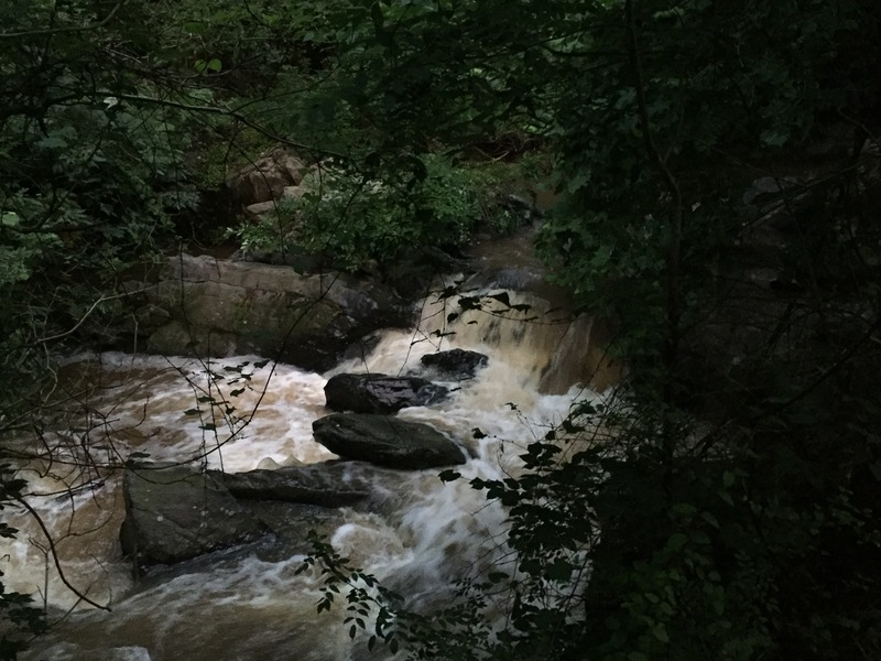
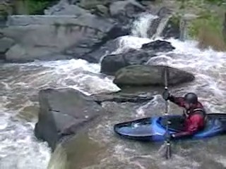
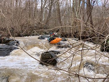
I finally got Piney Run at a descent level the week after the January 2016 Blizzard that dropped 28'. Piney Run was reading about 100 CFS with 6' of snow on the ground and all day of rain. Certainly could have had more water but it was still fun. Put in just below the Arrington bridge on Marriottsville Rd. 2. Slid into the creek down a snow bank. Several small eddies and boof rocks are available until you come to the first drop. The first drop is a 2' pourover best run in the center just right of the rock with a left boof stroke placed. Its easiest to head left right after the drop but it can also but cut hard right. The next 1/4 mile is class II/III boogie water with some cool features. The best part of the run is only .3 miles long MAX but can be extended to 0.8 miles if desired. Easy to park and run by walking back up Marriottsville Rd 2. Currently strainer free.
Aug 2, 2016
The main drop of Piney run is a 2' drop that requires a left boof stroke. You won't piton if you don't make your stroke but you land better if you do. Right after the drop you can stay far left or cut hard right between two more rocks and continue down. Lots of rocks to avoid broaching on. This is a fun micro creek best run after a big rain with the gauge reading at least 90 cfs and rising. Below 90 cfs is serious boat abuse. Over 200 cfs becomes more padded and pushy. Only micro eddies available. Parking is available at Arrington road and Marriottsville Rd. 2 or roadside on river left just below the main drop. You can easily park and run this several times. https://www.youtube.com/watch?v=PKDtQHg6hiM
Jun 28, 2006
Well, I managed to catch this in the early morning of 6/26, after it dropped sharply from what must have been righteous water in the middle of the night. The gauge was @2.0 and 80-90 cfs, although I might be reading it optimistically. The second drop below Arrington Rd is the hardest, with an unrunnable main line--I snuck it easily on the left. The level was a bit too low, but minimally adequate---bounce, bounce, crash, scrape. I pushed with my hands 2 or 3 times. I had one log portage. I wrestled under one more log that would have been in the way with good water. Below where I would have taken out, with more water, just above Marriotsville Road, there were three more log jams that I went over, through, and under, respectively, if I recall correctly. Taking out above these would have been no great sacrifice, but I continued because I could. I had fun. It's a nice little run.
Because the directions above are kind of nonexistent (for nonlocals), here: From I-695, take I-70 west to just past Route 29. Take Marriotsville Rd exit. Go North.
After 5 miles or so (my odometer is broken), you'll cross the Patapsco. Subsequently, the second left is Marriotsville Road #2. The creek runs along this. Arrington Road is at the obvious bridge on your left.
May 12, 2006
Rained 1.05 inches the night before
Rained 1.05 inches the night before fun little run